All Activity
- Past hour
-
 Melissa has arrived, and the scoring table has been revised again. It now has three potential alternative scores for these possible outcomes: After the scoring on current 13 4 3 ... second column is for Melissa becoming a hurricane. Third column is for a 14th named storm occurring after Melissa, in the event Melissa fails to achieve hurricane status, and also the 14th storm does not reach H. Fourth column is for a 14th named storm and either Melissa became a hurricane or the 14th storm does so. There are notes to explain how to derive other estimates not shown in the table, such as two more hurricanes out of those two storms, and/or one hurricane becoming major. Contest situation is interesting in that about a dozen forecasts stand some chance of winning at this point. If we get a November like 1887, even more would be in the running (I think there were three or four named storms and two were hurricanes in that distant season). The highest I could imagine this count going now is probably 16 6 4, the most likely outcome is 14 5 3.
 -
Well slightly better news tonight: Its 71 degrees BUT that dewpoint is steadily falling, I am watching it fall right thru the 40s!!! It's 42 now. This is a very DRY airmass, it is gonnabe nice and crisp later tonight when I venture out for some delivering. Time for the light coat! If only we had some rain and wind to go with it! I can barely feel it but we have a delightful NE wind at 5 mph!!!
- Today
-
I saw one flash to my SE does that count as a Thunderstorm for me
-

2025-2026 ENSO
PhiEaglesfan712 replied to 40/70 Benchmark's topic in Weather Forecasting and Discussion
1955, 1998, and 1999 would have been great analogs if we had a 175-185 ACE season and a strong la nina. We obviously do not have that this year, but for fun, I will do this run: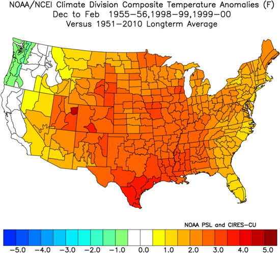
-

2025-2026 ENSO
40/70 Benchmark replied to 40/70 Benchmark's topic in Weather Forecasting and Discussion
I actually agree with you that this La Niña may end up a hair stronger than last year, after starting my deep dive. -

Mid to long range discussion- 2025
WinstonSalemArlington replied to wncsnow's topic in Southeastern States
-

E PA/NJ/DE Autumn 2025 Obs/Discussion
Birds~69 replied to PhiEaglesfan712's topic in Philadelphia Region
Moderate rain... -
Yeah I'm sure the NAM 3km is way overdone with the .75 to 1 inch for our area, but HRRR is probably underdone with the less than a quarter inch. Your prediction looks good -- probably close to a third of an inch. Obviously not enough to help with the drought, but I'll be happy to see the vegetable garden get a watering.
-
It was so nice today. Where did these clouds come from?
-
E PA/NJ/DE Autumn 2025 Obs/Discussion
Birds~69 replied to PhiEaglesfan712's topic in Philadelphia Region
Heavier stuff just to the West with yellow and some oranges,..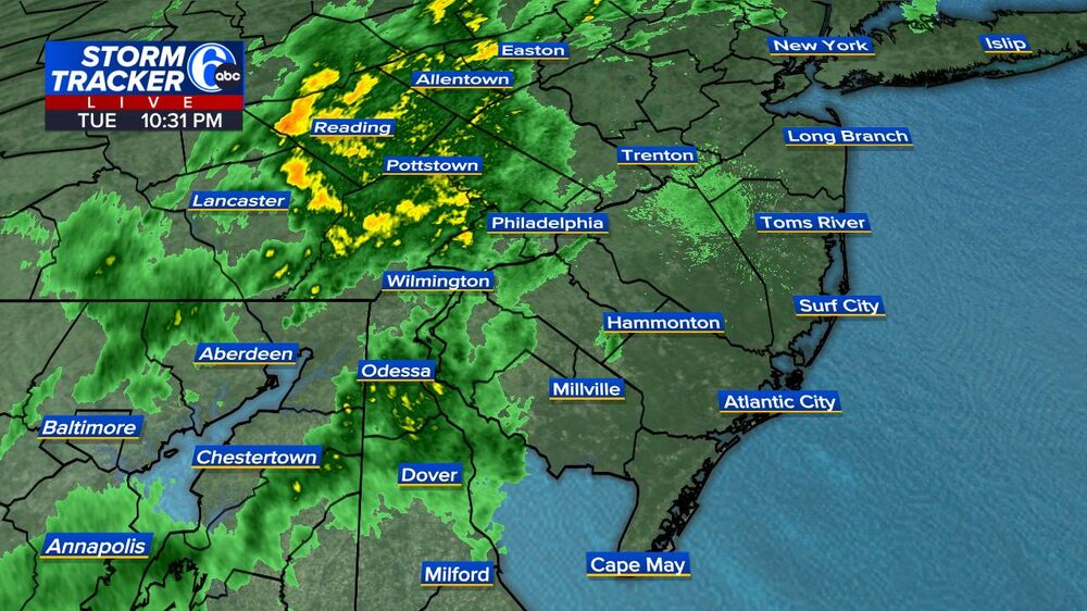
-
Yellow on. radar scope is moderate rain for sure. .01 in this part of Wantage so far.
-
That was a huge boomer at 8:45 that sounded like a big crash .
-
The extended products continue to depict a significantly +PNA and slightly -AO/NAO for the second week in Nov, with below normal temps for the east. Love me some chilly Fall weather.
-

E PA/NJ/DE Autumn 2025 Obs/Discussion
LVblizzard replied to PhiEaglesfan712's topic in Philadelphia Region
I was hanging out on my porch and was very surprised to see a lightning flash. Could be the last one we see all year as a fall/winter pattern looks like it will set in after this cold front passes. -
Last year we had to wait until the 3rd week of November to get below 40 and a week later to get below freezing.
-

Central PA Fall Discussions and Obs
canderson replied to ChescoWx's topic in Upstate New York/Pennsylvania
Nailed it. This is the few week of the year I never look at a forecast ha -

E PA/NJ/DE Autumn 2025 Obs/Discussion
Albedoman replied to PhiEaglesfan712's topic in Philadelphia Region
Just had a thundershower- light ---here in lower macungie -
Models have trended wetter for tonight and radar looks good. .25 to .5"
-

Central PA Fall Discussions and Obs
Itstrainingtime replied to ChescoWx's topic in Upstate New York/Pennsylvania
I wasn't following NWS today but MU was calling for showers between 5pm and 1am. -
Central PA Fall Discussions and Obs
Itstrainingtime replied to ChescoWx's topic in Upstate New York/Pennsylvania
Nice shower moving through here. About a tenth of an inch. -
Central PA Fall Discussions and Obs
canderson replied to ChescoWx's topic in Upstate New York/Pennsylvania
I was unaware there was a chance of rain tonight. -
Mid to long range discussion- 2025
WinstonSalemArlington replied to wncsnow's topic in Southeastern States
No more Warmth -

Spooky Season (October Disco Thread)
kdxken replied to Prismshine Productions's topic in New England
Good. Give it to New Hampshire. -
Mid to long range discussion- 2025
WinstonSalemArlington replied to wncsnow's topic in Southeastern States
-
+PNA and a sweet HL look. SE ridge crushed to oblivion. Non existent. It can happen! Lets hope it does when it really matters.


