All Activity
- Past hour
-
There sure is. Especially this week coming up.
-

E PA/NJ/DE Spring 2026 Obs/Discussion
RedSky replied to PhiEaglesfan712's topic in Philadelphia Region
35F low 7F colder then the night before -
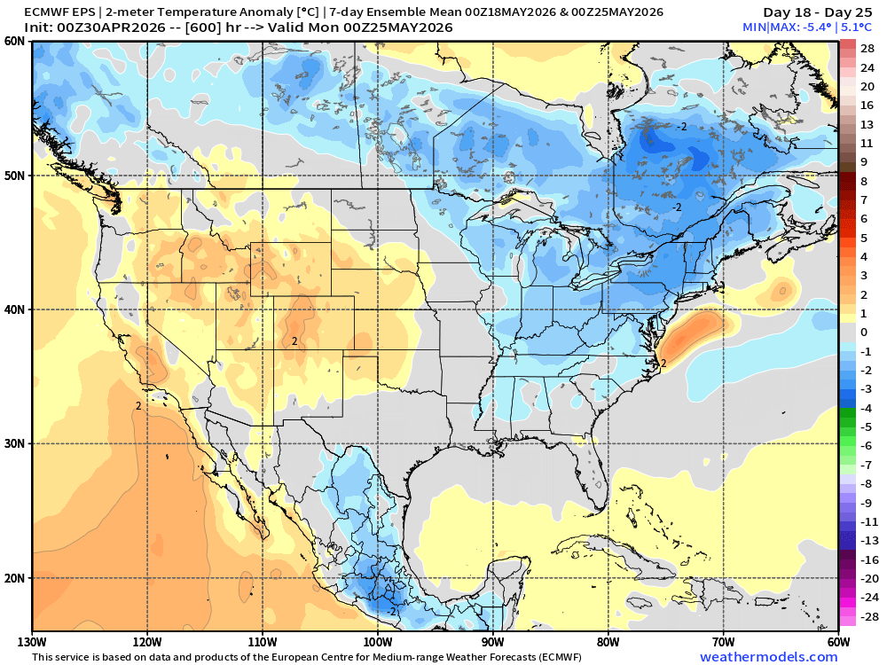
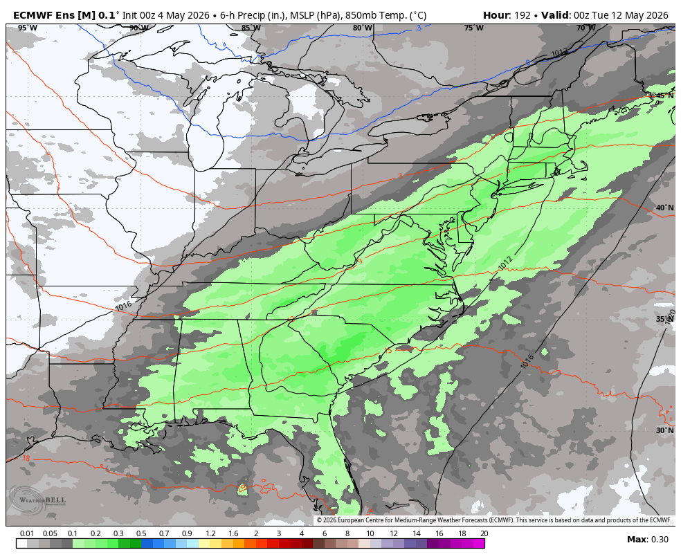
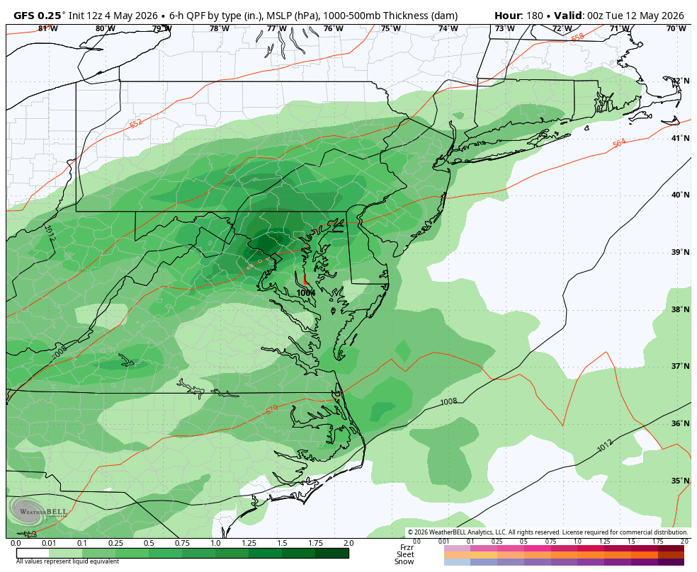
Next chance is early next week. WB 0Z EPS and 12Z GFS.


-
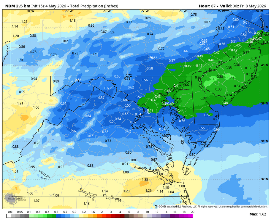
WB 15Z NBM for midweek.
-
12z gfs looking great still. Sent from my SM-G998U using Tapatalk
.thumb.jpg.05bb360a740e8f928f716b0b327cee3b.jpg)
-
Expansion of slight risk today into portions of the sub. Suppose the possibility of mildly spicy storms makes up for the blowing dust we have to contend with today.
-
Oh I wasn’t saying put your plants in the ground. But you cannot say that currently you’d expect 5/26 to be the mean last freeze in whatever climate we’ve got going. Sure, could pop a 30F on June 1st… but you know what I was getting at. Go look at those summer minimum temps from 1955-1975 and tell me that’s not different from what we see on average lately. It’d be entertaining to see mid-30s in CT valleys in July, always a chance.
-
Winds have started ripping here.
-
When I was in school, usually the janitor/maintenance guy had access to them. Thank you. I'm here all week.
-
Lol the famous never say never. You should know better
-
2023 we froze 5/18 believe me these low valleys can freeze right up to Memorial day let's not forget all it takes is one frost which is not recorded. No way do I plant before the end of May.
-

Central PA Spring 2026 Discussion/Obs Thread
WmsptWx replied to Voyager's topic in Upstate New York/Pennsylvania
I think what pisses me off is that right now it's sunny and 75°F and I'm sitting inside working. By the time Saturday rolls around, it'll be cold and wet again. Because at least here, that's how the weekends go in May. This past weekend I got home from my kid's T-Ball game, which was a nightmare because by the time all the pomp and circumcision was finished, it was cold, windy, and wet, and then snowflakes started mixing in with the rain. Two days later, it's a gorgeous spring day. And the point and click shows more cool and wet on the weekend to where I took time off work tomorrow to mow the grass because it already needs to be done again. Last year felt worse than this so far, but it seems like the first half of summer is going to be lousy. I can understand in Lancaster, where it's supposed to be warmer, it was. Here it's been a mixed bag. -
34F in July of 1956 and 34F in August of 1956. 9 of the first 12 years of that Coventry station back in the the 1950s and 1960s saw July min temps in the 30s. Good luck with that today. Looking at that reminds me of when Dendrite posts the old CON data and it just looks so far fetched to what we see these summers at night.
-
Holy wind
-
The data looks fine for the time frame... but given how we've seen last frost/freezes move over the past three decades, that could be like two weeks earlier now. It looks like the coldest was when the station started in the late 1950s, 1960s and early 1970s if you toggle to the late freeze dates. Skews almost to June 1 back then and then has been moving up until the last May/June data in 1990. https://wrcc.dri.edu/cgi-bin/cliMAIN.pl?ct1689
-
That area of town there is in a low valley too. Coventry as a whole is fairly hilly
-
Oh the Coventry, CT data ended in 1990... ok that makes sense of 5/26 back then. No way that still holds true 30+ years later.
-

Central PA Spring 2026 Discussion/Obs Thread
Jns2183 replied to Voyager's topic in Upstate New York/Pennsylvania
I think we forgot the essence of spring The idea that a "normal" April day in the Susquehanna Valley is a comfortable 65/45 split is more of a mathematical ghost than a daily reality. A 30-year rolling window analysis of Harrisburg-Middletown records from 1995 to 2024 reveals that April is less of a steady seasonal climb and more of a chaotic tug-of-war between competing air masses. While 65°F is indeed the mid-month mean, the standard deviation is a staggering 10.5°F—nearly double the volatility seen in the summer months—meaning the "average" is rarely the actual experience. The statistical distribution for April proves this "battle of extremes." In a stable month like July, about 61% of days fall within 5 degrees of the daily normal. In April, that frequency drops to just 35%. Instead of temperatures clustering around the mean in a standard bell curve, the data shows a flattened, high-dispersion pattern. We are far more likely to be swung into a late-winter cold snap or an early-summer heat spike than to sit at the theoretical average. By the time May arrives, the atmosphere begins to settle, with the standard deviation tightening and about 41% of days staying near the mean. April, however, remains the ultimate transitional wildcard. The "normal" day exists on paper, but the month is defined by its swings rather than its stats. If you're planning for a 65-degree afternoon, you're betting on the narrow middle ground of a month that statistically prefers to live in the extremes. [mention=317]Voyager[/mention] your wish on consistency in April is basically a fig dream. That's just not the reality that exists in Pennsylvania. Consistency is for June, July, August Sent from my SM-S731U using Tapatalk -
It was 38 here this morning on a forecast low of 45.
-
What's the climo period for that one? No way the past 30 years last 32F average is 5/26 there?
-
Yes while you on the hills mean last freeze is 4/30 Coventry down the road from you mean last freeze is 5/26
-
I would have done it yesterday but was so irritated by the chilly winds and clouds decided to do Saturday this coming weekend
- Today
-
Egads.... don't turn the wind onshore this summer.
-
Yes you live on a high hill
-
Damn Scott hope you are right. Need consistency with 70s 80s none of this 30s bullshit in the mornings either. EPS LR looks like the past month. A couple days here and there like today and tomorrow but crap overall if expecting long periods of summer. Looks much better by June
.png.7defe535c1eaaadfe37ef6b68a31c99a.png)
.png.6b27f0aa317b3b5126665448ccd8b5cd.png)


.jpg.9044e02deb335385823436be91ce48c1.jpg)


