All Activity
- Past hour
-
Can they give you an estimate on what you will gain or is it a gamble?
-
Sell all . Euro sucks in convection . Trust us
-
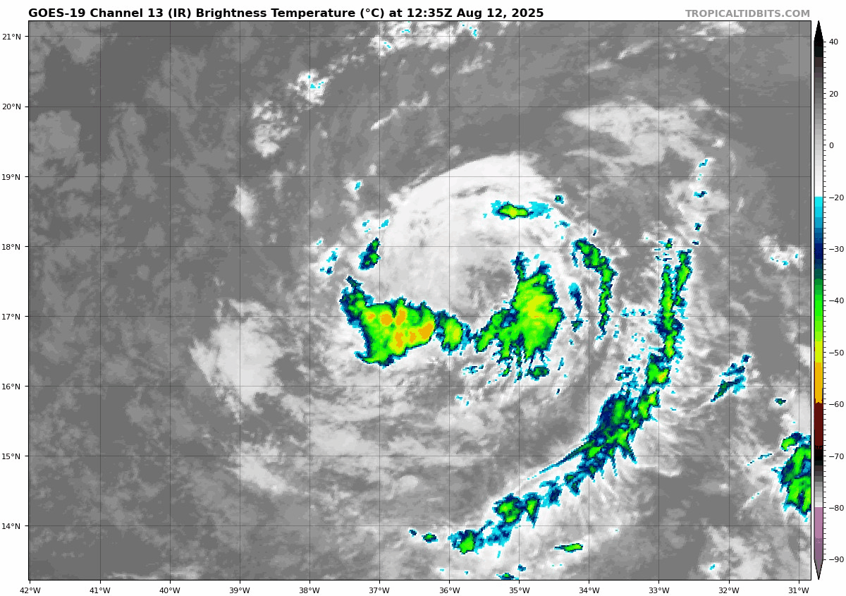
is this even a tropical storm right now

-
hispaniola shred?
-
Great Post!!! This is exactly what I was talking about earlier this morning. Erin is going to be ingesting in significant dry air looking at the push NE to SW from Sarhan Africa especially with that well defined broad circulation. I do predict moderate level of keeping in check and its likely to weaken as it moves west bound and possibly redirected west-southwest for a time due to the nature of the flow. That is an absolute brick wall of dry air. Erin's forward speed towards that brick wall is going to play a significant role as to what's going to happen from this very point clear on into the next 3-5 days because it is moving in tandem with this dry air layer from Africa moving west and southwest from Sarhan Africa.
-
Continuing to move south of forecast
-
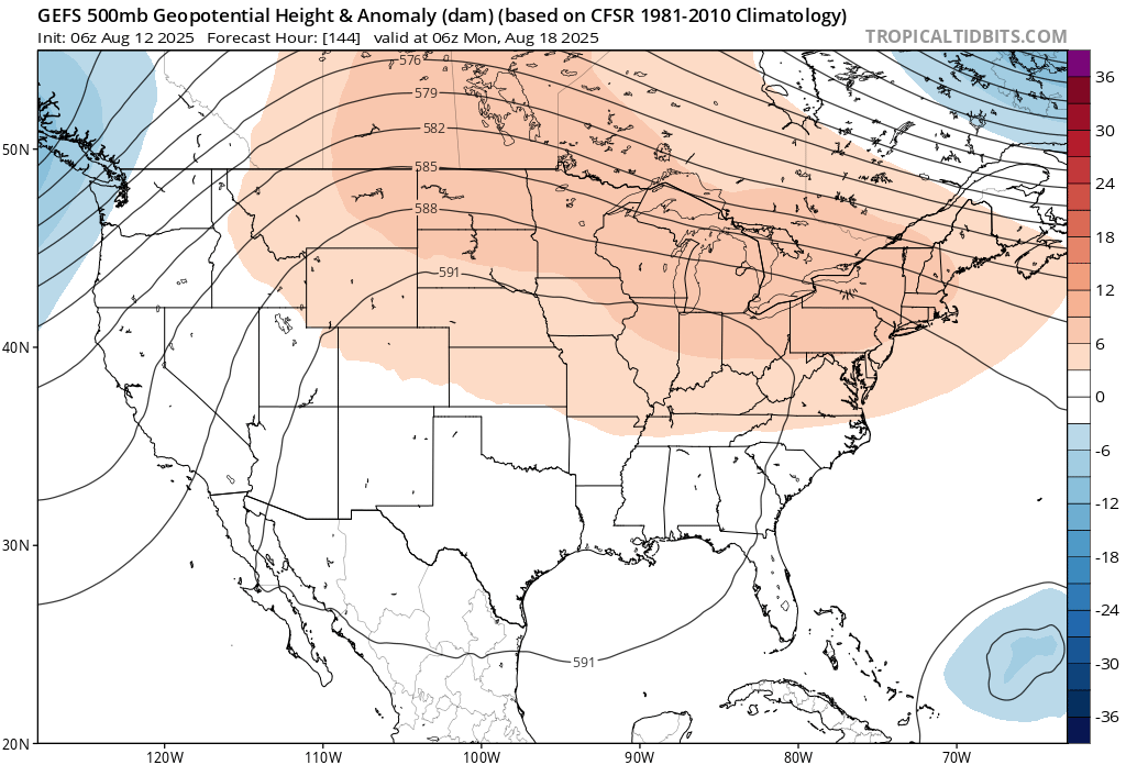
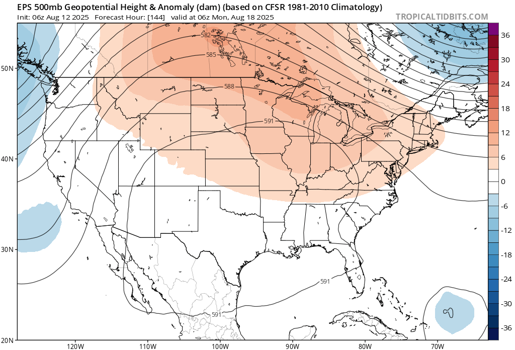
 Yeah, some of the AIFS members are closer to the Southeast than the EPS. This would be a big modeling coup for AI if it comes to pass. Could affect the whole pattern going forward. A slower development would allow a more southerly track.
 -
 it needs to develop into something first
-
If there were a record for the number of cloudy days during the summer with no rain we would break it easily this year...
-
 Not from that latitude way out east. This recurving near or just west of Bermuda
 -
 Onshore barrage / heavy rain there. We had more like a California first week here dry / onshore.
 -
Still a few around here. But far less Lots of acorns dropping though. Weird
-
 Very upside down month, based on the average highs for the first 11 days of August. Charlotte is nearly 7F colder than Burlington, Vermont, and 6F colder than Buffalo.
 -
For our friends in the Antilles, this is increasingly becoming a little close for comfort. Could be some indirect impacts there that become more direct if the south shift continues. To @40/70 Benchmark’s point earlier, that can muck things up if the ridge also ends up trending stronger or the big ULL in Canada is weaker in the long range. Still a lot to sort out here.
-
Tropical Storm Erin Discussion Number 5 NWS National Hurricane Center Miami FL AL052025 1100 AM AST Tue Aug 12 2025 Erin still has a well-defined low-level circulation, but the convective pattern has degraded since overnight, with only a band of moderate convection located within the southern part of the circulation. A 1226 UTC ASCAT-C pass showed a maximum wind barb of 36 kt north of the center, and the intensity is held at a possibly generous 40 kt. Most likely, this is a result of Erin's fast motion, which has been south of due west (265 deg) at about 20 kt. The guidance suite indicates that Erin may continue to lose some latitude during the next 24 to 36 hours due to strong low- to mid-level ridging over the eastern and central Atlantic, but overall the general motion should be westward through early Thursday. After that time, indications are that the ridge may weaken over the western and central Atlantic, causing Erin to turn west-northwestward, but there are model discrepancies on when that might happen and where the break in the ridge actually forms. The trend has been for a weaker Erin in the short term and possibly a stronger ridge, and a number of track models, including HAFS-A and -B, HWRF, the European, HCCA, and the Google Deep Mind, have shifted south and west for much of the 5-day forecast. The NHC forecast has shifted in that direction accordingly, and it should be noted that a significant number of deterministic models and ensemble members still lie even farther south. The environment of marginal water temperatures (26-27 deg Celsius) and low atmospheric instability and moisture appear to remain nearly constant for the next 24 hours or so. Therefore, little to no intensification is expected through early Wednesday. The environment and water temperatures become much more suitable for strengthening by 48 hours, and since the cyclone already has a well-defined structure, it could become a hurricane by late Thursday. Continued strengthening is forecast after that time, and the NHC forecast continues to show Erin becoming a major hurricane by day 5 (early Sunday). There is quite a lot of spread in the intensity models, and the NHC prediction is in the upper regime of the envelope, close to the SHIPS model, Florida State Superensemble, and ICON intensity consensus. KEY MESSAGES: 1. Although it is still too early to know exactly what impacts Erin might bring to the northern Leeward Islands, the Virgin Islands, and Puerto Rico, the risk has increased for Erin to move closer to these islands over the weekend. Interests there should monitor the progress of this storm. 2. There is even greater uncertainty in what impacts, if any, might occur in portions of the Greater Antilles, the Bahamas, the east coast of the United States, and Bermuda next week. As we approach the climatological peak of the hurricane season, this is an opportune time to ensure your preparedness plans are in place. FORECAST POSITIONS AND MAX WINDS INIT 12/1500Z 17.2N 36.3W 40 KT 45 MPH 12H 13/0000Z 16.8N 39.1W 40 KT 45 MPH 24H 13/1200Z 16.5N 42.3W 40 KT 45 MPH 36H 14/0000Z 16.6N 45.2W 45 KT 50 MPH 48H 14/1200Z 17.1N 48.3W 55 KT 65 MPH 60H 15/0000Z 17.8N 51.3W 65 KT 75 MPH 72H 15/1200Z 18.5N 54.4W 75 KT 85 MPH 96H 16/1200Z 19.8N 60.3W 90 KT 105 MPH 120H 17/1200Z 21.4N 65.0W 100 KT 115 MPH $$ Forecaster Berg
-
Truth! As I'm sure many feel similar/same, once we get to labor day, doesn't really matter how warm/muggy it is, as the signs/feels of fall are looming ever closer. Me thinks It's more of a mental victory in surviving summer.
-
Yeah, the record SST warmth near the Maritime Continent has been leading to significantly more -IODs over time than we used to get.
-
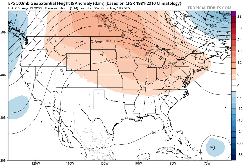
If you have the 6z EPS lat/long (TC position) @ hr 144, but 6z GEFS ULL intensity over eastern canada @ hr 144, that is a very interesting final solution...
-
Yep, and on August 12th it's more tolerable (to me at least) than a month earlier when it doesn't seem like there's an end in sight...
-
Half inch plus for you 6z models
.png.4371df5c98ea2cb369f1386549669af2.png)
-
Getting my well fracked on the 20th. Put a new pump in and expansion tank but recovery just isn't enough.
-
if erin doesn't recurve it changes the whole pattern. i could see it slipping south into the gulf
-
Morgantown did later go through its own heat island period for a time in the next decade, where it flipped the script and became a powerhouse of 90 degree days. In 1893, at the height of its ascent, it surpassed Pittsburgh by a whopping 35 days in that metric!
-
It's already fun to track the structure of Erin visually: looking to really shape up over the next day or two. https://weather.cod.edu/satrad/?parms=meso-meso1-02-96-1-100-1&checked=map&colorbar=undefined