All Activity
- Past hour
-

2025-2026 Fall/Winter Mountain Thread
Buckethead replied to Buckethead's topic in Southeastern States
Spruce Pine is still under a sheet of ice today. Sent from my Pixel 10 Pro using Tapatalk -
well yes but let me dream
-

The “I bring the mojo” Jan 30-Feb 1 potential winter storm
ObiWanKarlNobi replied to lilj4425's topic in Southeastern States

-

Possible coastal storm centered on Feb 1 2026.
tomcatct replied to Typhoon Tip's topic in New England
Ant used to pull all of these models out back in the nyc metro days -
After what seems like a train of downslope events, i'm sure most in our area would sign up for a 2-4" snow, especially if we don't have to use that term.......
-
So you're saying it wasn't even close?
-
Maybe the low will track in a favorable direction for East Tennessee.
-
96 and 2016 both trended north as we moved closer in. In 2016 Euro was way too low with totals in the I81 and I78 corridors. This is unusually low predictability, so that may cancel out modeling improvements since 2016.
-

Possible coastal storm centered on Feb 1 2026.
78Blizzard replied to Typhoon Tip's topic in New England
NIce timing for the 48 year anniversary. -
From that Weather Next run, ratio'd since temps are in the single digits and low teens and the entire column looks like a North Dakota snow sounding, I'd say 1 to 1.5 inches around Cookeville, 1.5-3 inches along the Plateau west to East, 1.5-4 along the central valley of East Tn, 3-6 for NE Tennessee/mountains.
-
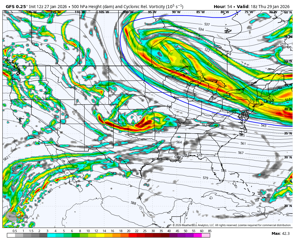
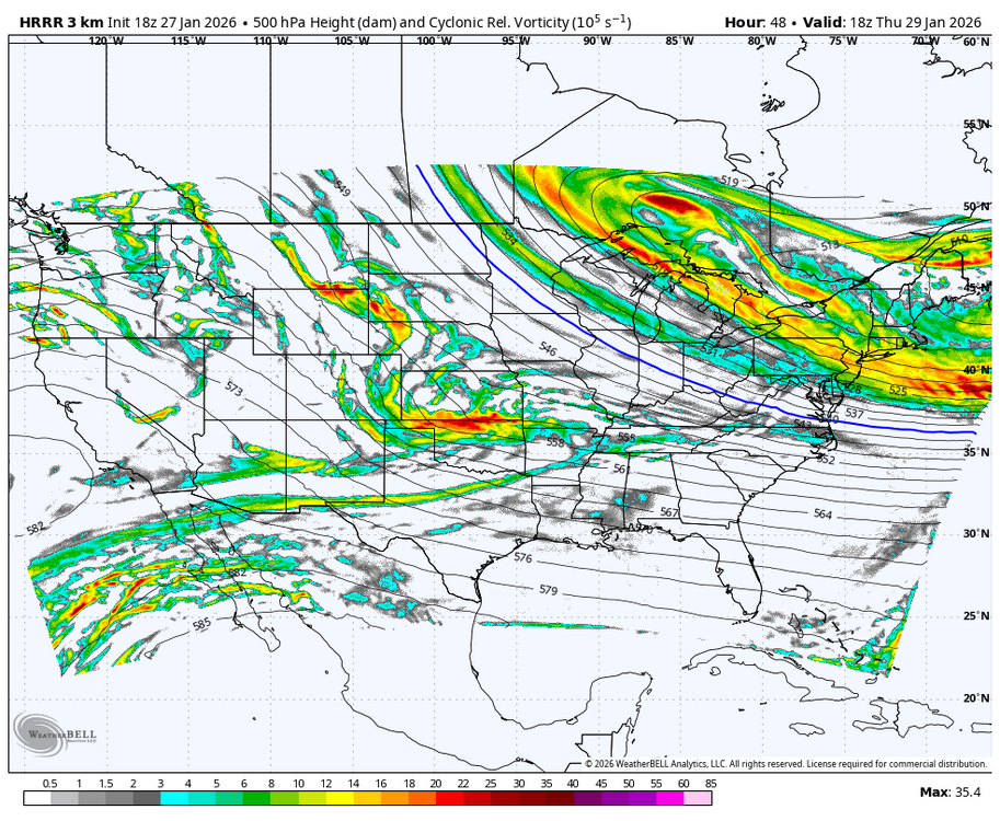
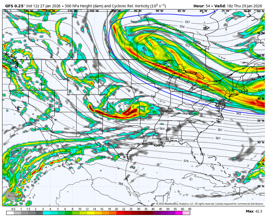
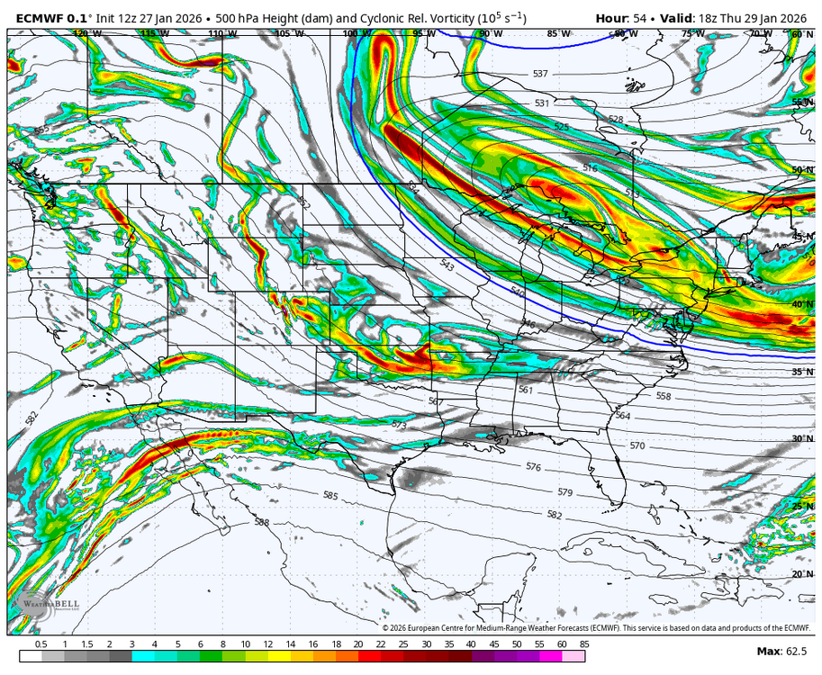
WB 18Z HRRR at range compared to 12Z GFS and EURO
-
Would give it til tomorrow, but writings on wall
-
So assuming our coming strat split happens, how long will it take to couple at the surface. I know @Stormchaserchuck1 might have stats on that.
-

January 25-26th, 2026 Final Storm Totals
The 4 Seasons replied to The 4 Seasons's topic in New England
you're tellin' me -

Pittsburgh/Western PA WINTER ‘25/‘26
Burghblizz replied to Burghblizz's topic in Upstate New York/Pennsylvania
Weenie model - but you have had the hot hand since last week. -
January 25-26th, 2026 Final Storm Totals
The 4 Seasons replied to The 4 Seasons's topic in New England
"Rockport gets destroyed in yet another Blizzard of the Century" Even stronger -

The “I bring the mojo” Jan 30-Feb 1 potential winter storm
RaleighNC replied to lilj4425's topic in Southeastern States
If we have enough models all doing something different, eventually ONE of them has to be right. -
We were literally 4 degrees away from a 25+ bomb

-
Posted that 2 hours ago. He's a copy cat! Lol
-

January 2026 Short/Medium Range Thread
fountainguy97 replied to John1122's topic in Tennessee Valley
Will be interesting to see what the High-res models do with the ULL moisture as they get into range. Even without the bomb Eastern areas may actually have a shot at the biggest snow of the year. -

Central PA Winter 25/26 Discussion and Obs
pasnownut replied to MAG5035's topic in Upstate New York/Pennsylvania
Thanks for sharing. as shown, if you adjust clusters you'd notice that GFS/Euro ensembles are very similar in placement. So to that end, we have good agreement, even though it still needs to continue westward ticks. THIS is the kind of consensus that we whould be looking for at this range. -
And the NAM much lower would be my guess? Sent from my Pixel 10 Pro XL using Tapatalk
-
I melted the snow and sleet in my large Tru-Check rain gauge. 2.10 inches Saturday/Sunday. The Canadian was the winner at 2.01 inches. The GFS said 1.90" and the EURO said 1.60".
-
It's crazy to see snow dumping over the gulf stream off the South Carolina coast. But here we are where it snows heavily over warm ocean areas but avoids it at all costs for East Tennessee.
-

The “I bring the mojo” Jan 30-Feb 1 potential winter storm
BooneWX replied to lilj4425's topic in Southeastern States
It’s been a long time since we’ve had lee side enhancement. I couldn’t even recall the last time we’ve had that setup. Long overdue.