All Activity
- Past hour
-
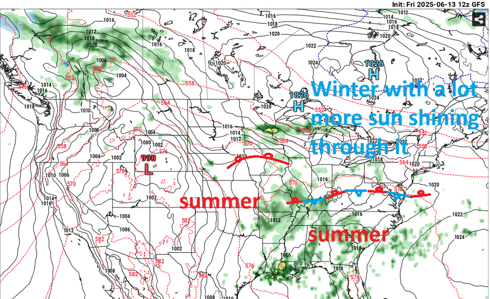
doesn't a ring of fire mean extreme heat here? those thunderstorms go to our north normally.
-
it hit 80 here at noon before the temperature dropped
-
I wouldn't say that, this could be one of the cooler rainier summers. I only turn on the a/c for a few hours late in the afternoon.
-
Yesterday is a prime example of JFK being hotter than ISP too, they average more 90 degree days than ISP does. It hit 80 here around noon before the clouds came back. We need more days like yesterday.
-
PXL_20250613_160850663.TS.mp4 The cicada bugs are out of control on the Cape... Give a listen!
-
One more week until fannies begin to take a bit longer to heat up when straddling car seats.
-
These cold rain shots drop the water temp for days. Let's get a real streak of summer.
-
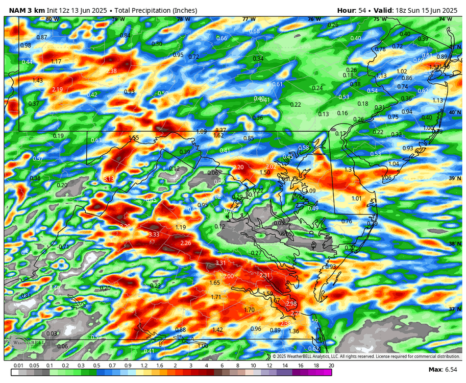
LOL. feast or famine, .17 go 15 miles and you are at over an inch, but of course this is the typical summer rainfall distribution outside of a solid line of storms. I am sure things will change.
-
WB 12Z 3K NAM through the weekend.
-
unfortunately ...making america great means losing a lot of tracking in that regard. guess it's not an all gain none lose deal, huh -
- Today
-
2025 ...FLOOD WATCH REMAINS IN EFFECT FROM 6 PM EDT THIS EVENING THROUGH LATE TONIGHT... * WHAT...Flash flooding caused by excessive rainfall continues to be possible. * WHERE...Portions of DC, including the following , District of Columbia, Maryland, including the following areas, Central and Southeast Montgomery, Charles, Prince Georges and St. Marys, and Virginia, including the following areas, Albemarle, Arlington/Falls Church/Alexandria, Central and Southeast Prince William/Manassas/Manassas Park, Culpeper, Fairfax, Greene, King George, Madison, Orange, Southern Fauquier, Spotsylvania and Stafford. * WHEN...From 6 PM EDT this evening through late tonight. * IMPACTS...Excessive runoff may result in flooding of rivers, creeks, streams, and other low-lying and flood-prone locations. * ADDITIONAL DETAILS... - Showers and thunderstorms will increase in coverage late this afternoon through this evening. Some thunderstorms will contain heavy rainfall, with rainfall amounts around 1 to 3 inches possible within an hour or two. Storms may also train over the same areas, causing the possibility for locally higher amounts around 4 to 5 inches of rain within a few hours. Heavy rainfall in a short period of time combining with already saturated soils means that creeks and streams may rapidly rise out of their banks along with the potential for flash flooding in urban areas. - Please visit www.weather.gov/safety/flood for flood safety and preparedness information
-
Let’s get tropical season going so we have something interesting to track
-
I often say Jesus after reading some of Canderson's posts.
-
Mid to upper 70s and fairly nice in downtown Worcester.
-
Sunny and 70’s today . Few showers tomorrow morning then cloudy
-
Sunny here so we take I guess.
-
Had one of our units fixed last week. $100 per lb of the coolant stuff $$$$
-
Eating lunch out on the deck. Temp wise not bad, 82 as I am still in shade on the backside facing West. Humidity though is thick 69 percent. Going to water my deck plants so when the sun does come over they are not shocked.
-
58° and OVC at noon. I was expecting it semi warm today.
-
Today is no prize either. cloudy and a cool 60 degrees. Not how we drew it up
-
Sad. I have a cluster of old neglected backyards and trees on my block so we get a bunch of them.
-
Dogshit Saturday enroute.
-
76 / 49