All Activity
- Past hour
-
Top ten afternoon. So glad to have a day without eye stinging campfire, monsoon or 95+.
-
 You should hear our chairlift chats, ha. Guy is a ton of fun to be around on the mountain, but we do get into it on some of that stuff. A lot of it is just not wanting to “the good ol’ days” to be done… but we get that vibe on here sometimes. That by admitting it’s warming doesn’t mean you think it’ll never get cold or snowy again.
 -
Brutal gradient in Orange and Durham counties. Verbatim would be great for MBY. We shall see.
-
Kinda like last year but we got rain this year so far. Which is lucky.
-
12Z UKMET is slightly stronger than 0Z with it showing 35 knots/barely TS this time before it dissipates by hour 60 moving W into LA, a similar track to 0Z/6Z runs. It then comes out S of LA but in a weakened state below TD status as it heads into the Galveston vicinity: TROPICAL DEPRESSION 02L ANALYSED POSITION : 28.4N 85.5W ATCF IDENTIFIER : AL022026 LEAD CENTRAL MAXIMUM WIND VERIFYING TIME TIME POSITION PRESSURE (MB) SPEED (KNOTS) -------------- ---- -------- ------------- ------------- 1200UTC 20.07.2026 0 28.4N 85.5W 1008 23 0000UTC 21.07.2026 12 28.8N 85.9W 1006 25 1200UTC 21.07.2026 24 28.7N 86.3W 1005 35 0000UTC 22.07.2026 36 29.4N 86.9W 1004 33 1200UTC 22.07.2026 48 30.1N 87.6W 1006 29 0000UTC 23.07.2026 60 CEASED TRACKING
-
Good to see recon out there for an extended period. The center is kind of meandering out there. You have to wonder if we see additional center reformations near the deeper convection with that northeasterly shear proving to be so strong.
-
 Another decent looking setup when you look at dynamics, however, doesn't look like there is going to be any room for cloud breaks tomorrow. Quite the soupy airmass, warm front nearby, and no capping. Going to be lots of clouds and pop up showers. Timing of the front/forcing not idea either...but...there may be a shot for some strong storms on Wednesday, especially east of the River.
 -
(002).thumb.png.6e3d9d46bca5fe41aab7a74871dd8af8.png) All three stations cooled at statistically the same rate as the surrounding stations. Additionally, in looking closer at potential TOB adjustments one may wonder why the West Chester 2NW and Coatesville 1SW records which predominantly relied on morning (AM) observations...so one would think the Raw TOB Distortion of an AM reading captures a naturally lower minimum, meaning the raw data was technically already too cool correct? The NCEI Adjustment you would think logically would be to correct for morning bias at Coatesville and West Chester by warming the historical record. However, NCEI's automated, grid-wide homogenization algorithms actually did the opposite by applying additional sweeping chilling adjustments to both of these stations data from 1895 through 1982.
All three stations cooled at statistically the same rate as the surrounding stations. Additionally, in looking closer at potential TOB adjustments one may wonder why the West Chester 2NW and Coatesville 1SW records which predominantly relied on morning (AM) observations...so one would think the Raw TOB Distortion of an AM reading captures a naturally lower minimum, meaning the raw data was technically already too cool correct? The NCEI Adjustment you would think logically would be to correct for morning bias at Coatesville and West Chester by warming the historical record. However, NCEI's automated, grid-wide homogenization algorithms actually did the opposite by applying additional sweeping chilling adjustments to both of these stations data from 1895 through 1982. -

2026-2027 Super El Nino
snowman19 replied to Stormchaserchuck1's topic in Weather Forecasting and Discussion
I agree Ray. I’m not understanding some of what I’m seeing on twitter calling for big west-based -NAO blocking this winter. Descending solar coming off a big max, high geomag, +QBO, super El Niño….sorry but that doesn’t scream -NAO blocking to me. But then again when you look at the account peddling that, it makes sense….. -

E PA/NJ/DE Summer 2026 Obs/Discussion
MGorse replied to PhiEaglesfan712's topic in Philadelphia Region
Got down to 56F early this morning. Currently 79F with a dew point of 53F. Nice! -
 Meanwhile, could be some fun in western zones tomorrow. Gotta get that warm front and its clouds through.
 -
 I always liked TK, but he’s def ACATT and definitely leans on the denying side.
 -
2026-2027 Super El Nino
snowman19 replied to Stormchaserchuck1's topic in Weather Forecasting and Discussion
I think it peaks strong come November -

2026-2027 Super El Nino
csnavywx replied to Stormchaserchuck1's topic in Weather Forecasting and Discussion
Record warm water volume this time: -

2026-2027 Super El Nino
GaWx replied to Stormchaserchuck1's topic in Weather Forecasting and Discussion
Do you have a guess for the +IOD peak? -

Central PA Summer 2026 Discussion/Obs Thread
canderson replied to Voyager's topic in Upstate New York/Pennsylvania
My Red Sox have won 13 straight. @Itstrainingtime’s O’s have won 7 straight. They meet tonight - let’s hope the O’s streak ends! -
2026-2027 Super El Nino
snowman19 replied to Stormchaserchuck1's topic in Weather Forecasting and Discussion
Here comes the +IOD….there are no road blocks ahead to stop this thing from strengthening and strengthening And with the projected TC forecasts, the WWBs and DWKWs are just going to keep coming -
The GFS, which has been playing catch up, has TD2 intensify a bit more than it did last run as it runs NW and then slides WSW below the LA coastline. AI GFS still weak.
- Today
-
I feel your pain. We’ve had some weird shield over us this week. I can’t even count how many times I’ve watched a storm miss me to the north through Dudley Shoals, and then 30 min later, Maiden.
-
 1 mg prednisone cost: TheraCore Pharmacy - TheraCore
 -
.thumb.gif.f92b16c631a1d15d405ed77b33f0710d.gif) Yeah only ~30 years on-air
Yeah only ~30 years on-air -

2026-2027 Super El Nino
40/70 Benchmark replied to Stormchaserchuck1's topic in Weather Forecasting and Discussion
Notice 1997-1998 didn't have a big +NAO? It occurred during ascending solar, not too far removed from solar min....not to mention -QBO. -
2026-2027 Super El Nino
40/70 Benchmark replied to Stormchaserchuck1's topic in Weather Forecasting and Discussion
@Stormchaserchuck1, I think I know why the connection between intense El Niño and +NAO seems overstated....the causation for the +NAO during intense El Niño is likely more due to higher-end El Niño being favored during descending solar/peak geomagnetic energy, rather then the intense El Nino itself. Descending solar/high geomagnetic is the actual "smoking-gun" behind the +NAO causation, however, intense El Niño with all of that warmth leaking east does inhibit -NAO, I'm sure. The combo together is lethal if you're hoping for big blocking. https://www.issibern.ch/teams/interplanetarydisturb/wp-content/uploads/sites/14/2015/01/Asikainen_03_2014.pdf -
2026-2027 Super El Nino
csnavywx replied to Stormchaserchuck1's topic in Weather Forecasting and Discussion
Yes. The keystone paper you're looking for is here: Influence of the state of the Indian Ocean Dipole on the following year’s El Niño | Nature Geoscience Made a note of it last year, but at that point it looked initially like a moderate event was most likely. wxchris on X: "The recent record/near record -IOD is collapsing. Warm water is sloshing east towards the WPac, putting the fully mature Nina on borrowed time. Expect whiplash. https://t.co/rZb3PjimBU" / X -
2026-2027 Super El Nino
GaWx replied to Stormchaserchuck1's topic in Weather Forecasting and Discussion
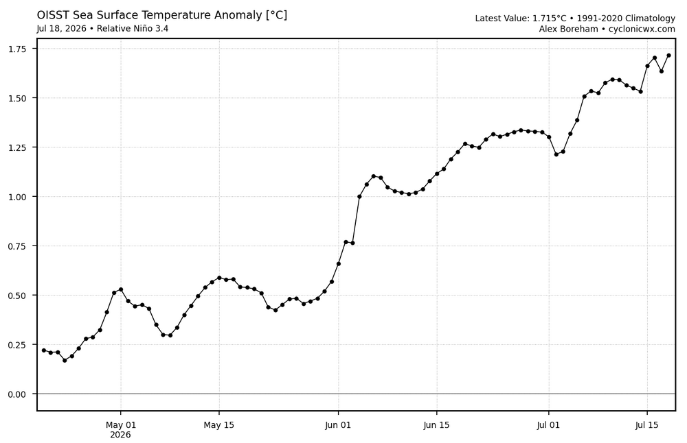
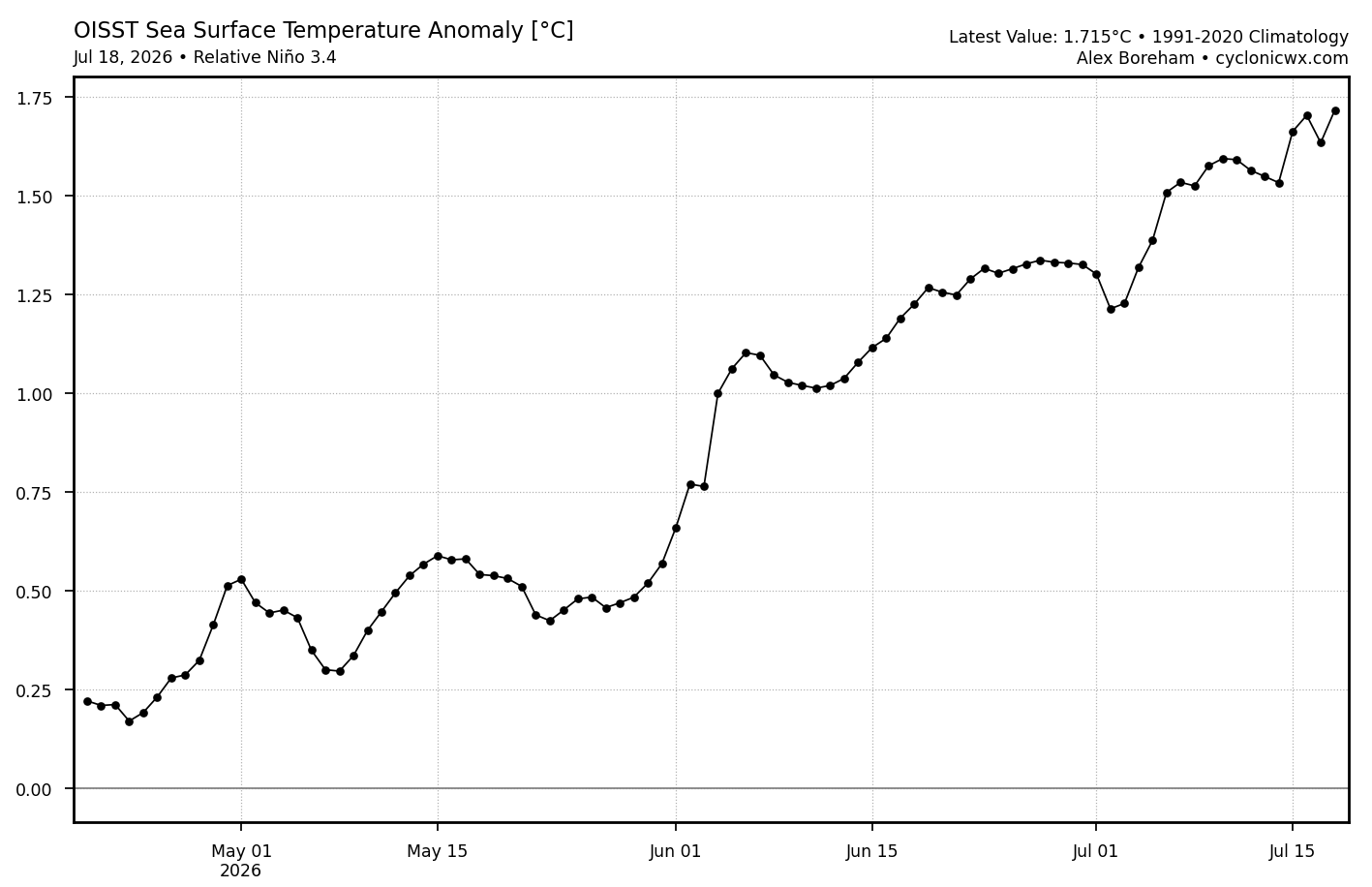
The weeklies keep coming in lower than my guesses as Nino 3.4 came in at only +1.4 for last week vs my +1.5 guess. This is surprisingly low when considering that it is OISST based. It is for the prior week averaged out, but still +1.4 looks low when comparing to this relative OISST graph. The avg of last week, the last 7 dots on the image below, is actually ~+1.6!