All Activity
- Past hour
-
Departures waning though each day since 8/1. Should be near to AN by Saturday. Then furnace as far as the eye can see. -1.5 for the new 30yr normal is like N to above in the 1980s lol. Smoke hasn't helped either. So basically you need onshore flow and dense smoke to stay BN.
-
Cockd, 73/58°F.
-
 By me in NJ there is a quarry, which has blasts from time to time. So if it is during the day time I have to ask, "quarry blast, or earthquake?"
 -

2025 Lawns & Gardens Thread. Making Lawns Great Again
dryslot replied to Damage In Tolland's topic in New England
Cucumbers coming fast and furious.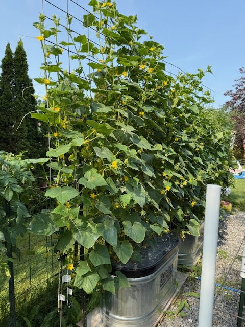
-
I’ve been up in the Hill towns every day, bringing my kid to theater camp and the trees are stressed. Droopy, leather leaves, and already getting color fade.
-
so are summer canadian airmasses just ruined forever now
-

2025-2026 ENSO
40/70 Benchmark replied to 40/70 Benchmark's topic in Weather Forecasting and Discussion
What is your NAO formula at currently? -
NW MA is real dry. We only got an appetizer from last week’s big rains and now the long range is Sahara.
-
Nothing but Stein thru day 10. Literally nothing
-
The latest Euro Weeklies (yesterday’s run) remain quite active vs active 20 year climo base ACE (>200%) through ~8/24. Then they cool down to close to active avg 8/25-31 (100%). The first stab at 9/1-7 is slightly below the active climo (80%). I wonder if this is MJO related. Regarding absolute ACE, the very active Aug 18-24 is the most active week through Sept 7. As per what I’ve recently posted, the EW progs did fairly well in general last year overall looking out several weeks when they were consistent for, say, 7 days in a row. They’ve been consistent regarding well above 20 year climo levels of activity for 8/11-8/24 for at least that long. Regarding 8/25-31, they’ve been near that 20 year climo for 3 runs. So, I still want to see how the rest of this week’s runs look before giving too much weight to its 8/25-31. Of course, 9/1-7 is a total crap-shoot right now with that slightly below 20 year climo being just its first prog.
-
 Another day of smoke filled skies. I wonder what it will take for people to realize we have a climate problem. If smoke filled skies doesn’t do it, I am not sure what will.
 -
If not for that stupid low offshore we probably could have gotten into some EML action this weekend and perhaps some MCS activity. that offshore kind of screws up the flow so hard to tell if we would have gotten something in here
-
Thanks!
-
Had a 51mph gust on a decaying line of showers that moved through around 6am.
-
Why is it when cpc says we’ll be wet it’s wrong but when it says we’ll be dry it’s right?
-
Okay, yeah I didn't look at the EPS last week to be honest. I just recall several cycles of operational runs showing higher heights aloft, with sfc 2-m's above 85 from those sources. Bravo to the EPS I guess... OH wait. Know what ... I may have f-up the time ranges. There was small interlude of +PNA that rippled through the continent and the operational warmth might have been more aft of that - possible. But, I do believe though that there's some idiosyncratic aspects that were not well handled, that have played into the cooler profile, too. Smoke being one of them. The last 3 days were more than just inconveniently pal looking skies. Plus, the high pressure moving through Quebec when working on top of smoke ...there's a bit of synergistic feedback there -
-
4 major climo sites all-5 every day this month BN that should continue until Sat then the great reversal for a week then slightly AN rest of the month. First 10 days BN AWT Sticking with Aug +1.5 due to big mid month heat wave.
-
Dews will not be in the 50’s. That was supposed to happen with the last two heat waves and it was in the 70’s
-
 30 days or so of snowcover out of 19.25" total is a small victory imo
 -
Turned out gorgeous
-
I could see 50s inland perhaps if its W to WNW flow. You'll notice anywhere near the coast (especially south coast) dewpoints are much higher with SW flow off the water.
-
A lot of our big heat days have had dews in the 50s. love those.
- Today
-
Dews that low though? I thought when it’s near 100F we are just roasting with dew points in the upper 60s instead of the dreadful mid 70s lol
-
Our highest temps typically have lower dewpoints. Lots of humidity in the air make it harder to get very hot temps.
-
Assuming it’s wrong , but on Tuesday the EURO shows temps in the mid to upper 90s but with dewpoints barely in the 50s. Don’t see that around here much..

.thumb.png.4150b06c63a21f61052e47a612bf1818.png)


