All Activity
- Past hour
-
 egg laid brain joined the community
 -

July 2025 Obs/Disco ... possible historic month for heat
CoastalWx replied to Typhoon Tip's topic in New England
I know I've said this before, but that was just cutting down the snow banks. I know it looks angry.....but do you honestly think there was any anger there in that situation? LOL. -
 Bright blue skies up here in Mahwah, 81 degrees.
 -
The usual Allegheny County flash flood warning in effect. Flash Flood Warning PAC003-125-011745- /O.NEW.KPBZ.FF.W.0095.250701T1451Z-250701T1745Z/ /00000.0.ER.000000T0000Z.000000T0000Z.000000T0000Z.OO/ BULLETIN - EAS ACTIVATION REQUESTED Flash Flood Warning National Weather Service Pittsburgh PA 1051 AM EDT Tue Jul 1 2025 The National Weather Service in Pittsburgh has issued a * Flash Flood Warning for... Central Allegheny County in southwestern Pennsylvania... Central Washington County in southwestern Pennsylvania... * Until 145 PM EDT. * At 1051 AM EDT, Doppler radar indicated thunderstorms producing heavy rain over Wilkinsburg, or near Penn Hills, moving east at 20 mph. Between 0.5 and 1 inch of rain has fallen. Additional rainfall amounts up to 1 inch are possible in the warned area. Flash flooding is ongoing or expected to begin shortly. HAZARD...Flash flooding caused by thunderstorms. SOURCE...Radar indicated. IMPACT...Flash flooding of small creeks and streams, urban areas, highways, streets and underpasses as well as other poor drainage and low-lying areas. * Some locations that will experience flash flooding include... Pittsburgh, Penn Hills, Mount Lebanon, Bethel Park, Ross Township, McCandless Township, Monroeville, McMurray, McKeesport, Canonsburg, Gastonville, Shaler Township, Plum, West Mifflin, North Side Pittsburgh, Baldwin, Upper St. Clair, Hampton Township, Scott Township and Wilkinsburg. PRECAUTIONARY/PREPAREDNESS ACTIONS... Turn around, don`t drown when encountering flooded roads. Most flood deaths occur in vehicles. && LAT...LON 4023 8027 4039 8026 4057 8000 4058 7977 4055 7977 4055 7974 4053 7971 4039 7975 4039 7976 4037 7977 4030 7979 4029 7978 4028 7980 4026 7979 4024 7981 4023 7980 FLASH FLOOD...RADAR INDICATED $$ MLB
-

July 2025 Obs/Disco ... possible historic month for heat
HoarfrostHubb replied to Typhoon Tip's topic in New England
It’s one of my favorite snow related pictures ever. From one of the best winters ever. -
July 2025 Obs/Disco ... possible historic month for heat
CoastalWx replied to Typhoon Tip's topic in New England
Those were the days. I think back to that year a lot. Three winter seasons of complete angst and hopelessness has finally got me. I'm broken and as someone who used to love winter...it's not the same feeling anymore. -
July 2025 Obs/Disco ... possible historic month for heat
CoastalWx replied to Typhoon Tip's topic in New England
LOL how do you still have that? -
welcome to the swamps of dagobah!
-
Well this sounds exciting. The combination of appreciable instability and highly anomalous PWAT values will make storms today capable of producing very high instantaneous rainfall rates.
-
 It’s is incredibly muggy out there. Dew is 75
 -
July 2025 Obs/Disco ... possible historic month for heat
HoarfrostHubb replied to Typhoon Tip's topic in New England
You angered Ullr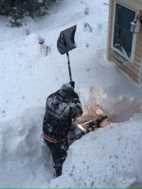
-

July 2025 Obs/Disco ... possible historic month for heat
40/70 Benchmark replied to Typhoon Tip's topic in New England
I love their young core...but ownership and management needs to stop getting in their owm way, and need to start adding as opposed to just switching out pieces. Cora needs to go. -
July 2025 Obs/Disco ... possible historic month for heat
CoastalWx replied to Typhoon Tip's topic in New England
He is the one diamond amid the steaming pile of shit that team has become. I'm so disgusted. -
Yeah, this aint going to be pretty if we go over 1" totals.
-
This morning's 12z balloon had 2.07" PWAT which is right about climatological max for this time of year. We got the smashed spider hodograph though, so expecting some wet down-bursts later.
-
July 2025 Obs/Disco ... possible historic month for heat
40/70 Benchmark replied to Typhoon Tip's topic in New England
Not worried in the least about him. His skills so far are among the best rookies in the game. -

July 2025 Obs/Disco ... possible historic month for heat
Torch Tiger replied to Typhoon Tip's topic in New England
P sunny and muggy in Salem, feels nice. -

July 2025 Obs/Disco ... possible historic month for heat
powderfreak replied to Typhoon Tip's topic in New England
Nice to see a few multi-hit games in a row. He hits the ball hard when he does. -
Got a nice soaking around 4 am. The lawns will be happy
-
July 2025 Obs/Disco ... possible historic month for heat
40/70 Benchmark replied to Typhoon Tip's topic in New England
I do watch the Sox mainly for Anthony, though. -
July 2025 Obs/Disco ... possible historic month for heat
40/70 Benchmark replied to Typhoon Tip's topic in New England
Other games....I have the Extra Innings package. -

E PA/NJ/DE Summer 2025 Obs/Discussion
Newman replied to Hurricane Agnes's topic in Philadelphia Region
My brother in Lititz last night got smoked with nearly 6" of rain. More on the way today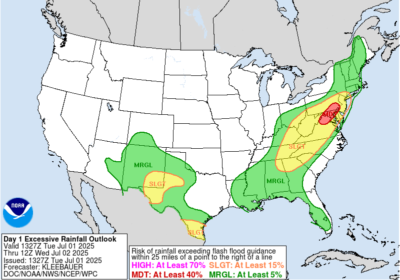
-
2.46" yesterday 5.93" June
-
The activity in western PA/WV/MD looks to have a good forward motion to it. #lookingforbrightspots
-
2.83" of total rainfall for me, with 0.03" falling since midnight.
-
Precip departures For June: GSO -.25 RAH -.42 FAY -.15 Charlotte +1.39 Greenville +1.88 Asheville +2.16 Wilmington +.67