All Activity
- Past hour
-

November 2025 general discussions and probable topic derailings ...
dryslot replied to Typhoon Tip's topic in New England
OVC, 34/32F, Going to be a chilly week. -
Should be a fun on folks. 12z Nam 3km has my location getting 3” or so inches of snow and the higher parts of the neighborhood getting 5”-6” per the WeatherFront App. I have never been able to zoom in so close on a snowfall map so we will see how accurate that is. Anyways looking forward to our first chance of the year!
-

November 2025 general discussions and probable topic derailings ...
qg_omega replied to Typhoon Tip's topic in New England
3 to 5 feet locally per NWS -

11/8-11/10 First Snow and Lake Effect Event
sbnwx85 replied to Geoboy645's topic in Lakes/Ohio Valley
I’m liking the trends on the HRRR locally. It keeps the main band overhead for several hours this late afternoon and evening before the mesolow swings through. Tomorrow afternoon and evening will have to be closely watched out here for round 2. -

November 2025 general discussions and probable topic derailings ...
CoastalWx replied to Typhoon Tip's topic in New England
60 right now. Amazing out. Let’s get the GFS run and have stein blocking. -
November 2025 general discussions and probable topic derailings ...
CoastalWx replied to Typhoon Tip's topic in New England
Gonna need to be on the water I think. I always think ORD as Chicago because that’s where I used to forecast for. They always underwhelm. Still want to be SE of the city, but they’ll get snow. Looks like they get the comms head briefly and may pound then, but after that as Dendy said, they’ll be a narrow band and a few miles means moonshine or pound town. -
Reel it in fellas. Hope to see some magical photos tomorrow.
-

Occasional Thoughts on Climate Change
Typhoon Tip replied to donsutherland1's topic in Climate Change
`Well there you go... if what you are saying is true ( bold ^ ...I'll leave that up to you) than it shows - this just a little logic application and critical analysis, they are dubious (and immoral by the way) without even knowing their history. -

Central PA Fall Discussions and Obs
Itstrainingtime replied to ChescoWx's topic in Upstate New York/Pennsylvania
Thoughts on Grunkemeyer? I'm pleased with his progress over 3 starts, especially given who he's faced. -

November 2025 general discussions and probable topic derailings ...
mreaves replied to Typhoon Tip's topic in New England
The drop off from Chicago to Joliet would me maddening. -

November 2025 general discussions and probable topic derailings ...
WinterWolf replied to Typhoon Tip's topic in New England
It’s felt quite autumn like for a good month now..so yes. -

November 2025 general discussions and probable topic derailings ...
dendrite replied to Typhoon Tip's topic in New England
The last month has averaged a hair AN, but we haven’t had anything absurd since the first week of October. Of course everyone know’s my opinion about the new normals, but we don’t need to go there after Friday. -
November 2025 general discussions and probable topic derailings ...
WinterWolf replied to Typhoon Tip's topic in New England
What are you trying to do? You obviously feel the need to keep stirring the pot. Why? This is a weather forum. Obviously we all have different ideas on things. I suggest you stop the instigating, and stick to weather discussions. If you want to talk politics or what not, we have a thread for those things. So you can Take it there. -
November 2025 general discussions and probable topic derailings ...
WinterWolf replied to Typhoon Tip's topic in New England
I don’t understand some of these people. Yesterday was gorgeous…but other than that, it’s been very autumnal for weeks. 56 here now..feels nice. But then it’s showers and very cool coming up. -
November 2025 general discussions and probable topic derailings ...
dendrite replied to Typhoon Tip's topic in New England
There’s an inverted trough that swings through there N to S. The mesos initially push a convective band (horizontal to the flow) southwestward through the city and then behind that it aligns into a typical LES streamer where it slowly shifts east from the city to IN. But I agree with Scoot. I think the heaviest is more east toward the IN/IL border. But it should be pretty cold on the west side of the LES with NW sfc flow. -

November 2025 general discussions and probable topic derailings ...
powderfreak replied to Typhoon Tip's topic in New England
I was thinking that… that’s a huge area of 12”+ for a mesoscale style event. -
 Actually... They are calling for 10"-16" in Chicago proper tonight and another 2"-4" tomorrow.
 -
This is one of the more impressive lake effect events on Lake Michigan this time of year as a lobe of the TPV tracks behind the synoptic low just east of the Great Lakes.

-
November 2025 general discussions and probable topic derailings ...
CoastalWx replied to Typhoon Tip's topic in New England
Think I would want to be near IL/IN border -
November 2025 general discussions and probable topic derailings ...
CoastalWx replied to Typhoon Tip's topic in New England
It didn’t look impressive on hrrr or nam for the city. Maybe further SE? -
November 2025 general discussions and probable topic derailings ...
powderfreak replied to Typhoon Tip's topic in New England
Silver dollar aggregates.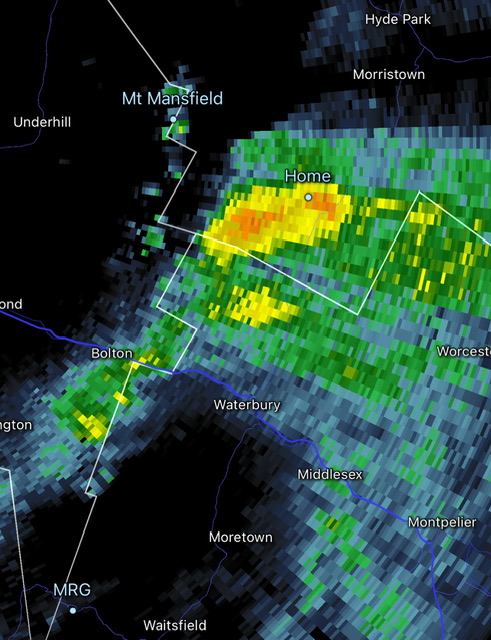
-
It was still too brief a phase 8 last January to significantly weaken the Pacific Jet. So the kicker shortwaves coming into Western North America prevented the record Gulf Coast snowstorm from coming up the coast. Our last impressive MJO 8 was back in January 2022 allowing the Pacific Jet to relax and the great snowstorms to affect ACY-ISP-BOS.
-
 62f, Sunny.....torch-like?
 -
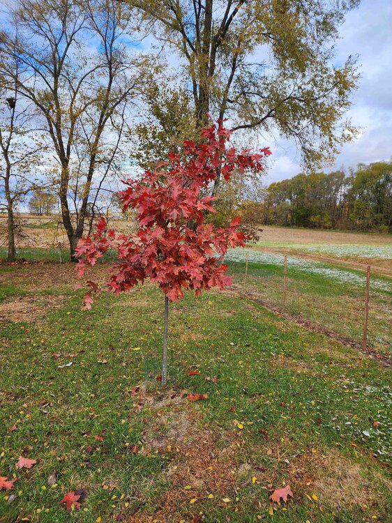
Northern red is at full peak. Oaks running a little behind this year in color, but most are nearing peak now.
-
Great Notre Dame football game last night in the snow showers!