All Activity
- Past hour
-
Short-lived.
-

October Comes Early: Late September Multi-Hazard Hybrid Storm
HIPPYVALLEY replied to WxWatcher007's topic in New England
If it was winter, it would’ve cut 300mi west or have gone out to sea. -
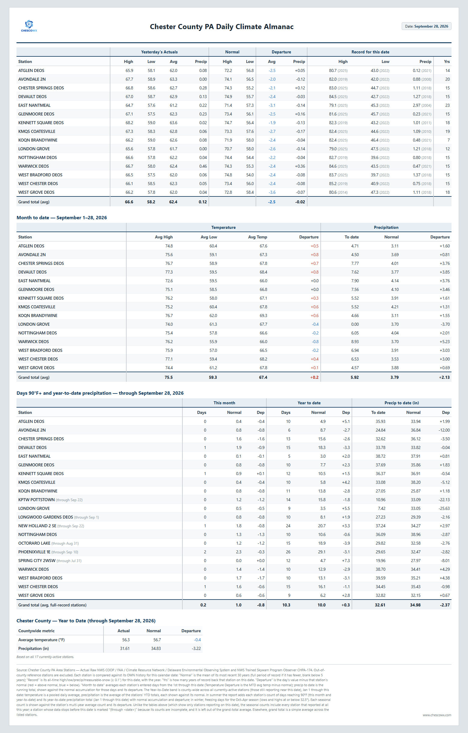
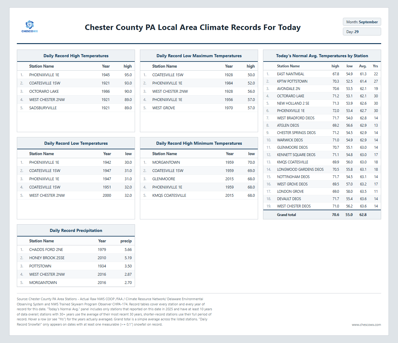
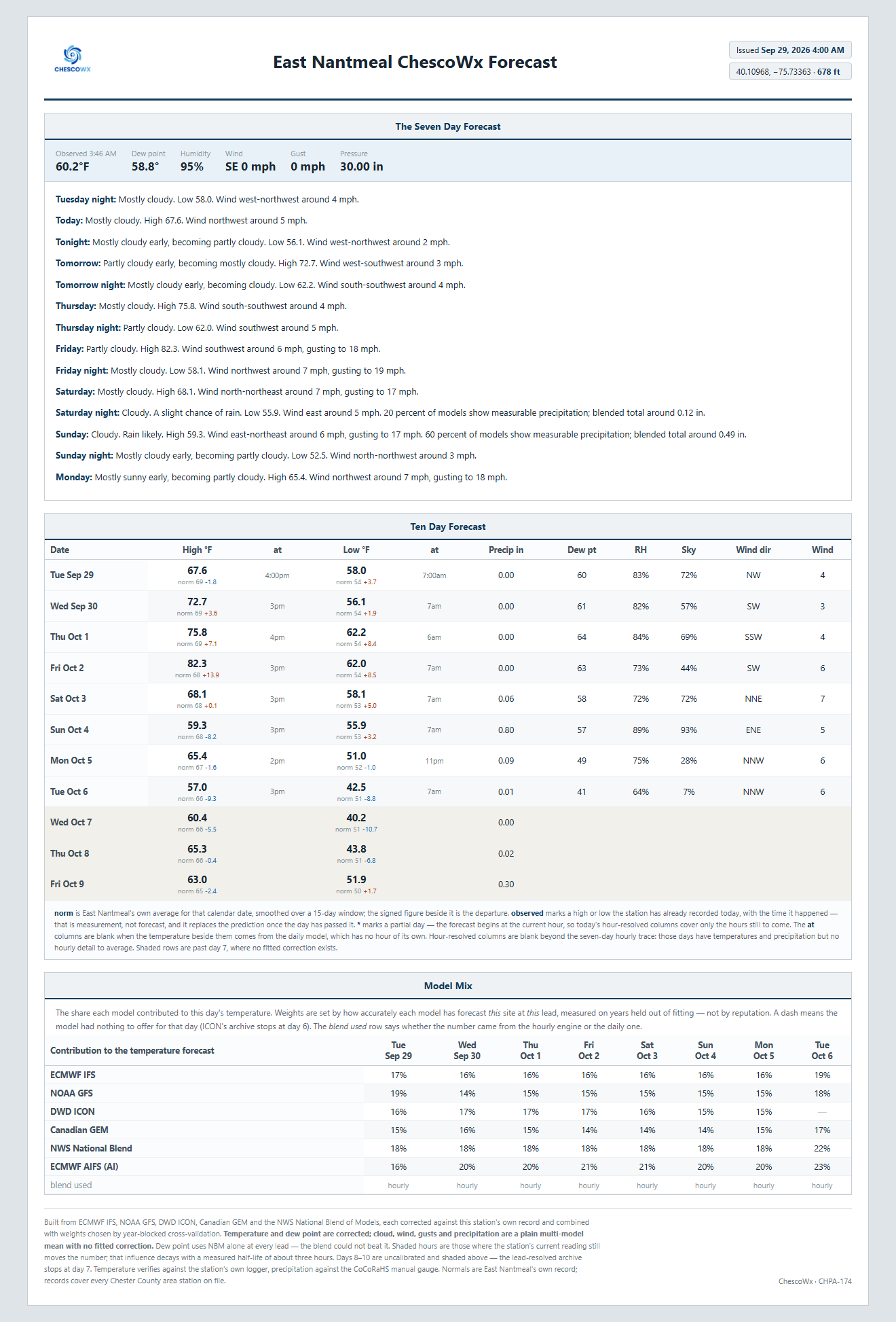
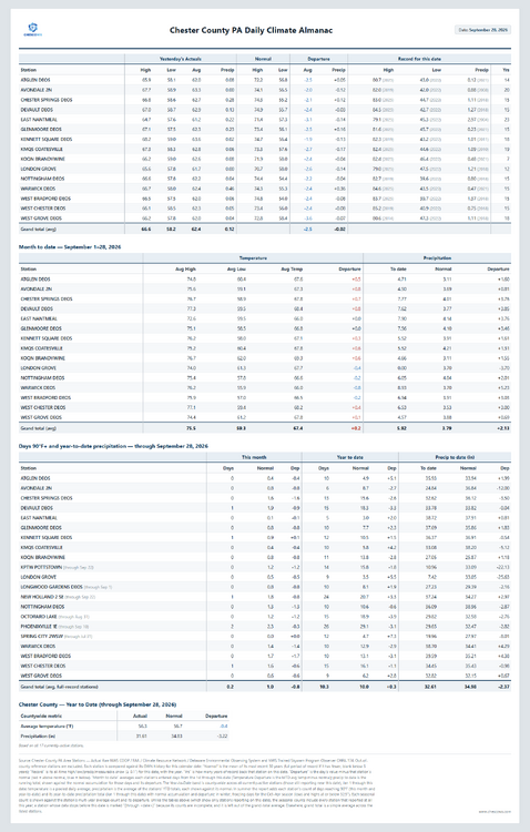
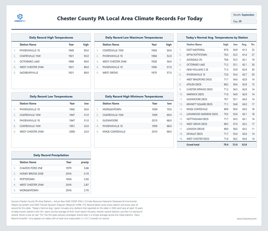
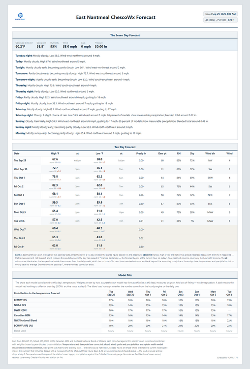
Happy Red October (a little early) for those that celebrate - GO PHILLIES! A nice stretch of warmer weather and sun through the remainder of the work week with temperatures possibly touching 80 degrees by Friday! We turn cooler again and wetter by the weekend.
-
(002).thumb.png.6e3d9d46bca5fe41aab7a74871dd8af8.png)
E PA/NJ/DE Autumn 2026 Obs/Discussion
ChescoWx replied to PhiEaglesfan712's topic in Philadelphia Region
Happy Red October (a little early) for those that celebrate - GO PHILLIES! A nice stretch of warmer weather and sun through the remainder of the work week with temperatures possibly touching 80 degrees by Friday! We turn cooler again and wetter by the weekend.
-

2026 Atlantic Hurricane Season
bigtenfan replied to Stormchaserchuck1's topic in Tropical Headquarters
As a S Florida resident I will take 8 storms like this every hurricane season. . -

Record Number of Extreme 10”+ Rainfall Months Since 2003
bluewave replied to bluewave's topic in New York City Metro
September 2026 was the 3rd consecutive month with parts of the area going over 10” of rain. Monthly Data for September 2026 for Upton NY NWS CWA Click column heading to sort ascending, click again to sort descending. CT NORTHFORD 0.8 SW CoCoRaHS 12.33 NY CENTEREACH 1.3 NE CoCoRaHS 10.70 NY SELDEN 1.6 ESE CoCoRaHS 10.67 CT DARIEN 2.4 NW CoCoRaHS 10.35 NY PORT JEFFERSON STATION 0.3 SSW CoCoRaHS 10.27 NY RIDGE 1.8 SE CoCoRaHS 10.18 -

2026 Atlantic Hurricane Season
vortex95 replied to Stormchaserchuck1's topic in Tropical Headquarters
The 1961-1990 avg is 10.5 NS per year. The current 30 yr avg 1991-2020 is 14.5. In last 10, is it 18. Lots of factors. 1) 1970-1994 was an unfavorable phase of the AMO for Atlantic TCs. Since 1995, it has been favorable. 2) Many more short-lived TS that used to be not declared or missed now get a name and as late as 1994, an off-season HU was not counted/included. 3) Prior to about 2000, NHC rarely declared/included ST storms. Since that time, they declare them routinely. Also, from 1989 to 1994, there was only one operational GOES satellite for the U.S. and it was positioned at 98W So this meant no real coverage for the eastern Atlantic. Meteosat and polar imagery were available for this part of the Atlantic, but it was not received in real-time for hurricane ops. Another thing that changed is when the next generation GOES became available by 1995, not only did we have two GOES satellite again for better coverage, but also image resolution and frequency from these new satellites increased. And when we got to the next "next" generation of GOES satellites, launched in 2017, the resolution of imagery increased again and the amount of data per hour went up by more than an order of magnitude. For instance, we get a full disk every 10 min now. Prior, it was only every 3 hr. A CONUS every 5 min, It was only every 30 min prior. And we went from 5 satellite channels to 16. This all greatly enhanced our capabilities to track and diagnose TCs in real-time. Purely from a standards/practices and technological POV, you can't compare on a level playing field prior decades to the last 3 or so when it comes to NS counts. And this applies for the entire globe. A true long-term avg, accounting for AMO cycles, needs to be 50-70 years of high quality data. -
Same here. We have seen so many modeled hits fizzle out.
-

September 2026 Medium/Long Range
Stormchaserchuck1 replied to JenkinsJinkies's topic in Mid Atlantic
I was 15, keeping a weather journal. Only year I ever did one. Picked one hell of a year for that huh! I was looking back and there was snow 4x in October, but it could have been flurries, or even just flakes -

Septorcher 2026 Discussion - Endless Summer
Great Snow 1717 replied to Damage In Tolland's topic in New England
Is the September torch happening today or tomorrow?? -
 discount ed pills and cheap ed pills best online ed medication https://www.google.pt/url?sa=t&url=https://apexmenmeds.com ed med online or https://act2day.eu/profile/kxoipgypsu/ online erectile dysfunction medication [url=https://www.google.gg/url?sa=t&url=https://apexmenmeds.com]buy erectile dysfunction medication[/url] cheapest ed medication or [url=http://asresin.cn/home.php?mod=space&uid=1246443]best ed medication online[/url] buy ed meds
 -
...Is it too early for me to come out of hibernation? How much snow will I see this year?
-
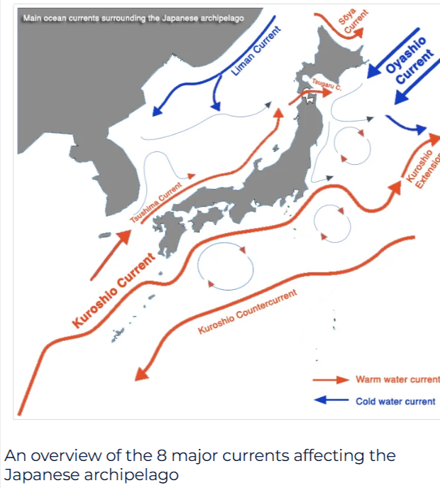
Starting to believe why we see it so warm in the West Pac is being caused by the Kuroshio Current. The Kuroshio is a feeding area for typhoons in which they can strengten SIG. as they track towards East Asia But the Kuroshio forms eddies and in which helps transport warm surface SSTS along it.Seen a couple papers i read in relationship to the ENSO when its a Central based NINO.The Kuroshio isnt as strong but also said more studies needed I believe its around the Kuroshio extension has the strongest currents in the world
-
I didn't think I was going crazy. BWI reported no snow in 10/02...not even a trace. For BWI, snow in November is a good (but not guaranteed since nothing in weather ever is) sign, but not October.
-

2026-2027 Record-breaking El Nino
40/70 Benchmark replied to Stormchaserchuck1's topic in Weather Forecasting and Discussion
I agree....they way I interpret that is some second half volatility. I don't see the season averaging -NAO. I think wave reflection is the path this year....like 1983. I don't think a reversal is in the cards. Guidance may try to flag one, and then back off. -
 8.27” final. Nice drink. Let’s see if we can get some sun out the rest of the week to green up that lawn.
 -

October Comes Early: Late September Multi-Hazard Hybrid Storm
CoastalWx replied to WxWatcher007's topic in New England
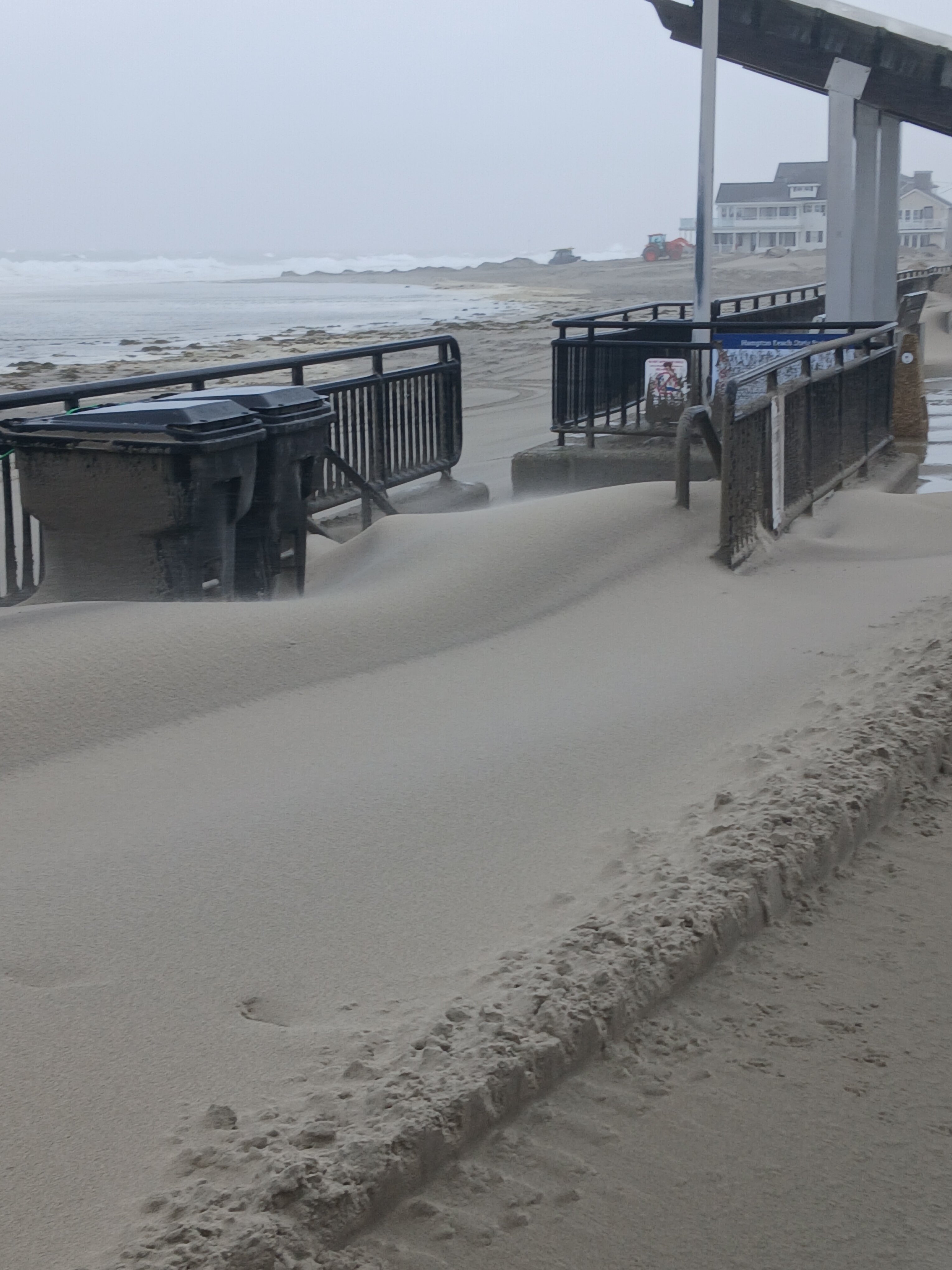
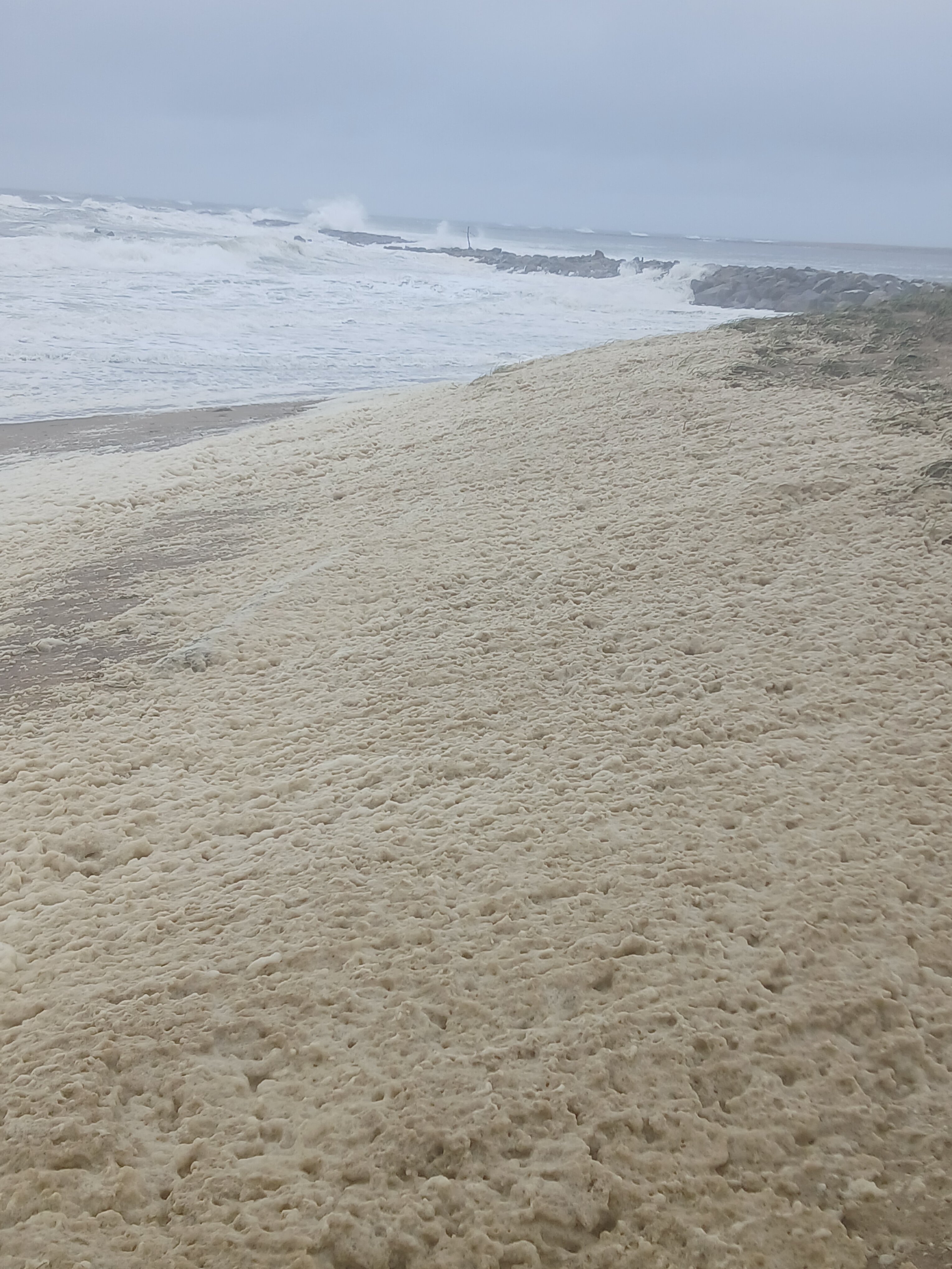
Ha that’s pretty cool. Haven’t seen sand drifts like that. -

October Comes Early: Late September Multi-Hazard Hybrid Storm
ineedsnow replied to WxWatcher007's topic in New England
We drift!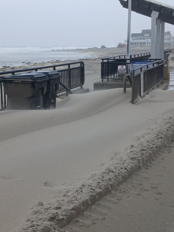
- Today
-
October Comes Early: Late September Multi-Hazard Hybrid Storm
ineedsnow replied to WxWatcher007's topic in New England
didn't stand in it but I did see a lady pick some up.. there was a ton of it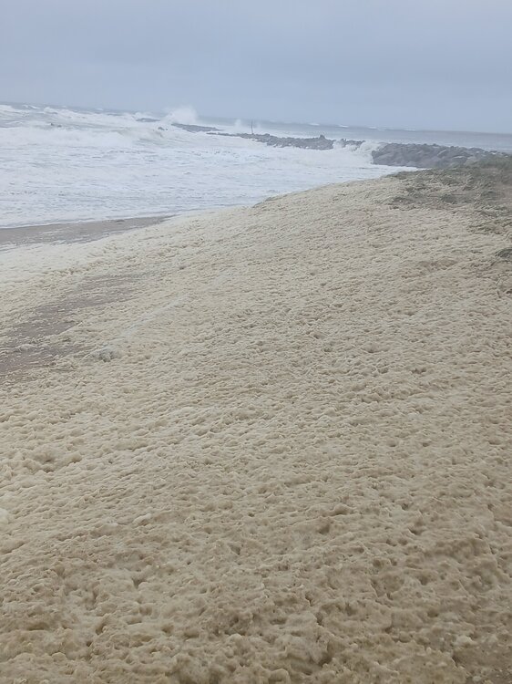
-

2026-2027 Record-breaking El Nino
LibertyBell replied to Stormchaserchuck1's topic in Weather Forecasting and Discussion
The summer of 1983 behaved like a la Nina though from June through September with the endless historic heat. I see the same thing for next summer. Same reason as 2015-16 with the Kara block added in? Did we have such a block in February 1983 too? -
Above normal is the not-so-new normal.
-
Looks slightly negative overall.. with seasonal models. I just don't know that I think we are in a -NAO time right now
-
Generic Cialis without a doctor prescription: TadaStream - Buy Tadalafil 20mg
-
2026-2027 Record-breaking El Nino
40/70 Benchmark replied to Stormchaserchuck1's topic in Weather Forecasting and Discussion
Both are elite polar analogs. -
2026-2027 Record-breaking El Nino
LibertyBell replied to Stormchaserchuck1's topic in Weather Forecasting and Discussion
Did you mean December 1992 Chris? That storm was far more historic than this one. Like 1983 it won't stop a historic hot summer for next year. Yes but 1983 had an exceptional endless hot summer from June through September so the el nino did not make the summer cooler. 1982-83 and 2015-16 had some similarities. If anything it would be less snow than 1997-98 as that late March event was a complete fluke and the airports got less snow. 2001-02 had even less snow. At the coast latitude doesn't really matter unless you're north of 42N you have the potential to be completely shut out of snow. Both 1982-83 and 2015-16 were far better for snow than 1997-98 was with much more late season blocking. In April 1983 JFK had their latest snowfall on record.