All Activity
- Past hour
-

Feb 22nd/23rd "There's no way..." Storm Thread
winter_warlock replied to Maestrobjwa's topic in Mid Atlantic
I seriously think this guy hates snow he's always a downer . Every model could be showing a blizzard and he's gonna say" well because the butterfly's in China are flying upside down it's probably gonna rain but that's ok everyone's water tables will be good " -
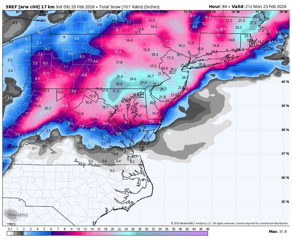
I feel like the GFS slowed backed the moisture up to the West as we got closer to the event, Euro did the best at showing the dry slot over Raleigh first and the heavier snow that fell through the upstate it picked up on that first. The Nam was all over the place and the GFS AI and Euro AI did the best at identifying the heaviest totals near CLT-Salisbury area. With in 18hrs the RAP and HRRR pretty much held course with the future radar, but a blend of GEFS and EPS is the way to go in my opinion and cut everything back a little bit with daytime snow in late Feb. It will be interesting to see how it plays out!
-

Pittsburgh/Western PA WINTER ‘25/‘26
Rd9108 replied to Burghblizz's topic in Upstate New York/Pennsylvania
Yeah I dont think we jackpot but with the SREF this snowy it bodes well for us to get a minor-moderate event. I said it before Ill take a 3-6 type right now. This was never gonna be the big one for us so not upset we are missing it. -
You mind quoting it? I can't find that post.
-

Feb 22nd/23rd "There's no way..." Storm Thread
GreyHat replied to Maestrobjwa's topic in Mid Atlantic
Thanks, but I didn't start with the negative comments on anyone. -

“Cory’s in NYC! Let’s HECS!” Feb. 22-24 Disco
bristolri_wx replied to TheSnowman's topic in New England
I don’t think so. They realized the one they were going to put into production was bad. The MPAS versions are already scoring better verifications…. -
also did you notice that extreme amount in the dark grey on the GFS seems to be moving north each run now its in southern half of NJ it was down in tthe Del Marva a day or 2 ago ???
-

Feb 22nd/23rd "There's no way..." Storm Thread
Interstate replied to Maestrobjwa's topic in Mid Atlantic
I think someone needs a timeout
-
The last time I saw a big shift like this with the SREF was in Jan 2016 with Jonas. Sref was the 1st model to trend northward with the storm two days out
-

“Cory’s in NYC! Let’s HECS!” Feb. 22-24 Disco
CoastalWx replied to TheSnowman's topic in New England
Tides don’t seem very high but they’re not low either. 10’ tide in BOS harbor. -
Feb 22nd/23rd "There's no way..." Storm Thread
GreyHat replied to Maestrobjwa's topic in Mid Atlantic
You don't know me and I don't care to know you. -

Feb 22nd/23rd "There's no way..." Storm Thread
DDweatherman replied to Maestrobjwa's topic in Mid Atlantic
I stuck up for you getting a hard time from people a few weeks ago, but this morning you’re bringing the heat upon yourself… -
lundberg def did not seem happy about snow, saying no one really wants it but what ca n you do....hard for people here to digest that most others feel that way.
-
“Cory’s in NYC! Let’s HECS!” Feb. 22-24 Disco
CoastalWx replied to TheSnowman's topic in New England
I’m sure they’ll shoe horn in the RRFS without it being ready. -
Feb 22nd/23rd "There's no way..." Storm Thread
Interstate replied to Maestrobjwa's topic in Mid Atlantic
Give me one good thing you have brought to the forum... other than the increased whining... have you bought any good analysis? -
Feb 22nd/23rd "There's no way..." Storm Thread
GreyHat replied to Maestrobjwa's topic in Mid Atlantic
I guess reality is hard for you. -

Feb 22nd/23rd "There's no way..." Storm Thread
snowfan replied to Maestrobjwa's topic in Mid Atlantic
Appreciate your honesty. -

Pittsburgh/Western PA WINTER ‘25/‘26
Burghblizz replied to Burghblizz's topic in Upstate New York/Pennsylvania
GFS isn’t entirely on its own. I think this is a stat padder, not an event. But this keeps me vested.
-

“Cory’s in NYC! Let’s HECS!” Feb. 22-24 Disco
ScituateMA replied to TheSnowman's topic in New England
Anyone know what the storm surge potential is looking like on the south shore of MA? -
They can’t get rid of the NAM because everything they come up with to replace it is worse.
-

Feb 22nd/23rd "There's no way..." Storm Thread
T. August replied to Maestrobjwa's topic in Mid Atlantic
I feel like before every storm people forget that even in the middle of the day, snow can accumulate at 33/34. -
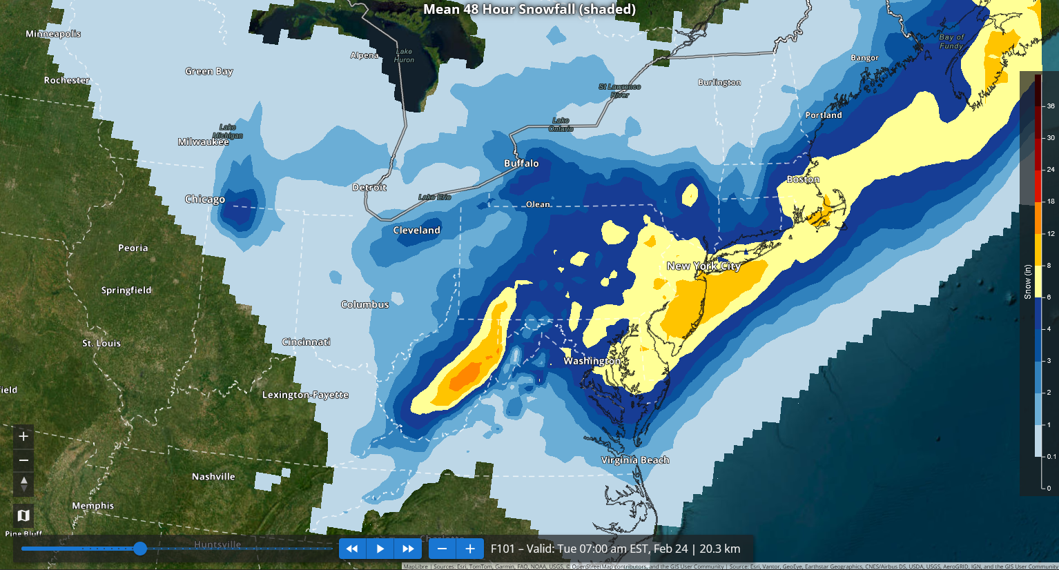
That's incorrect. NWS forecast for NB through NYC is 4-6" through 7 am Monday, which would be 5-7" through the end of the storm at 1 pm Monday, assuming use of the NBM (which they said they followed closely). See my other post with the maps and such.
-
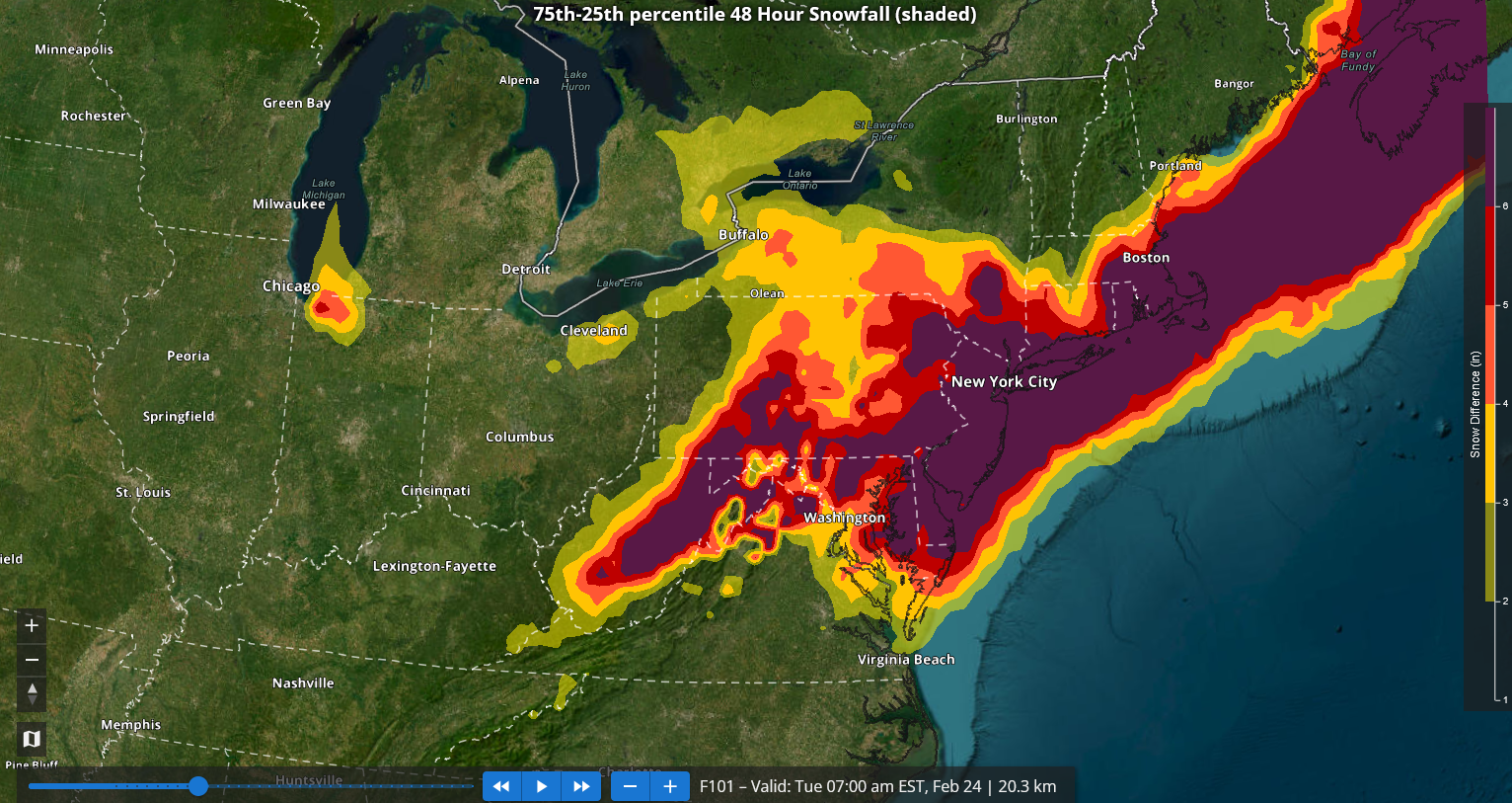
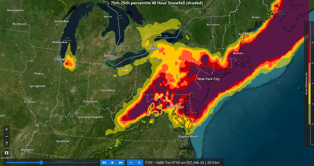
For reference, here are the 7z NBM numbers, including the spread between the 25th and 75th percentiles: Snowfall: Spread: A large area, including the New York City region has a 6" or above spread. In short, big changes are still possible.

-

Feb 22nd/23rd "There's no way..." Storm Thread
aldie 22 replied to Maestrobjwa's topic in Mid Atlantic
You're up late isn't it past your bedtime? -
Feb 22nd/23rd "There's no way..." Storm Thread
GreyHat replied to Maestrobjwa's topic in Mid Atlantic
Oh