All Activity
- Past hour
-
I see a couple ORH 56’ and Monson 11’ upcoming
-
Hopefully we get one crazy severe day in there. Jaw-dropper
-
We think it can and will
-
Well we’ll endure this weekend and hopefully move into high summer by mid next week. Near the solstice. Imagine that!
-
18z goes bonkers D9 - 6/20/95 anniversary btw. wish that could happen again

-

June 2025 discussion-obs: Summerlike
LongBeachSurfFreak replied to wdrag's topic in New York City Metro
I Left that one out because it doesn’t have a 100% mortality rate like borrer and beech leaf. But yeah it is also a problem. If we lost oaks, that would be an ecosystem destroyer. They feed tons of wild life and we do not have chestnuts as a backup. -
91 here today
- Today
-
Don't forget Oak wilt. That's becoming more of an issue.
-
“Happy” hour. I’ll be in the drought thread if you need me
-
Don't they start coming out in July though?
-
Also with these new dewey, hot summers in the NE, it'd be smart to invest in bidet biz/tech/installs.
-
you know it's gonna be a "real one" hot summer when folks begin the wiping vs bidet references
-
Lanternfly numbers are actually down this year so far anyway.
-
What in the Sam hell is going on in here?
-
I need a left shoulder replacement and Im a lefty wiper, they suggested I get a bidet.
-
At DCA today the high temperature failed to reach 90 degrees, which has been true of every day this year. Since 2003, when DCA recorded its first 90 degree or greater reading of the year on June 24th, the first 90+ reading has occurred in a range from April 6th to June 11th. Thus, this year's first 90+ reading (which may occur tomorrow) will be the latest in (at least) 22 years. FYI, the latest day of the year in official DC weather history for the first 90+ reading is July 12th, which occurred in 1979. That year, like 2003, there were a total of twenty 90+ days. The (two) years with the fewest number of 90+ days in DC history occurred much further back -- in 1886 and 1905, with seven each. In 1886, the first 90+ day was July 7th and the last was September 28th; in 1905, the first 90+ day was June 6th and the last was August 13th. At the other end of the spectrum, the (two) years with the greatest number of 90+ days in DC history occurred in 1980 and 2010, with sixty-seven each. In 1980, the first 90+ day was May 13th and the last was September 23rd; in 2010, the first 90+ day was April 6th and the last was September 25th.
-
Yep. TP is disgusting. I hate hotel travel because most don’t have bidets. So I got an RV. I literally drag my toilet behind me.
-
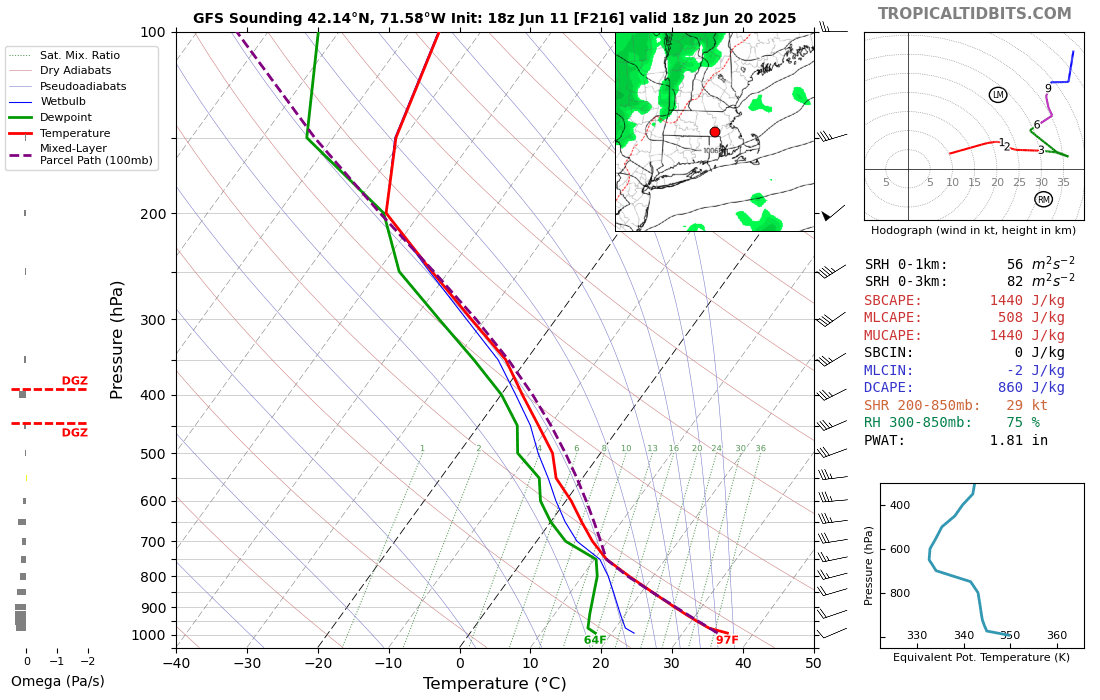
We don't typically get washouts in mid June. The pattern supports frontal action, which tends to be scattered in nature. As advertised there is some decent instability and PWAT moving northward on the western side of the Atlantic HP, so there is the potential for some locally heavy rains at times. The haves and have nots to be determined.
-
June 2025 discussion-obs: Summerlike
LongBeachSurfFreak replied to wdrag's topic in New York City Metro
Yeah the lantern fly craze had allot to do with PR from the wine industry as they definitely damage grapes. But overall are just a nuisance. Just raked out my veggie garden which is exploding with the warm sunny weather today. -
I am hugging the Euro thru June 24. I love the Europeans!
-
Zebra mussels doing their thing
-
I should hit 90 tomorrow I don’t think DCA has. Wonder how late that is compared to last 25 years?
-
Turned into a gorgeous day. The haze has really thinned out this afternoon. Summer is the goat.
-
We had this big complex of rain hit us last night. We waited 6 hours for it. When it finally got to us in Austin it stalled about 40 miles off to our west and swirled. We got about a third of an inch then the damn thing just kind of dissolved, as in it turned to clear skies, then part of what remained slammed into Dallas for the 3rd night in a row, then East Texas got waterboarded all morning into this afternoon. Talk about Cursed! Flood watch is in effect 3 miles to my north. Damn. Lucy resides in Hays County TX and she loves to pull that rainy football right out from beneath me, EVERY TIME! I'd pay exorbitant taxes for more rain.
-
Tomorrow will be the warmest day of the week with the mercury rising into the upper 80s across much of the region. The warmest spots will likely reach or exceed 90°. Friday will see temperatures top out near 80°, but it will turn cooler for the weekend. Shower and periods of rain are also likely during the weekend, especially Saturday afternoon and Sunday. Sunday will likely be particularly cool with the high temperature struggling to reach 70° in New York City and many areas around the City staying in the upper 60s. Rainfall amounts will generally be light with most of the region seeing 0.25"-0.50" of rain. No exceptional heat appears likely through the first three weeks of June. The ENSO Region 1+2 anomaly was +0.4°C and the Region 3.4 anomaly was 0.0°C for the week centered around June 4. For the past six weeks, the ENSO Region 1+2 anomaly has averaged +0.23°C and the ENSO Region 3.4 anomaly has averaged -0.07°C. Neutral ENSO conditions will likely continue through at least mid summer. The SOI was -7.59 yesterday. The preliminary Arctic Oscillation (AO) was +0.658 today. Based on sensitivity analysis applied to the latest guidance, there is an implied 59% probability that New York City will have a warmer than normal June (1991-2020 normal). June will likely finish with a mean temperature near 73.0° (1.0° above normal).