All Activity
- Past hour
-
My point about the username has more to do with a lack of seriousness and the performative nature of the poster coupled with the chav speak (you are most welcome) - I doubt anybody found the whole thing particularly funny or entertaining. Social media is there so you can put on a performance if you so please, I doubt that is what anybody is signing up for in a meteorological forum. .
-

Pittsburgh PA Fall 2025 Thread
jwilson replied to TheClimateChanger's topic in Upstate New York/Pennsylvania
I'm curious why we seem to hit our peak heat in June and then have "cold" shots in August. Shouldn't that be reversed? Is that just recency bias? Kind of an interesting dynamic. This is looking forward to winter, but that dominant -PDO is something to note from this summer, how it may affect our winter. -
The warmth will eventually

-
this is exactly the type of bullshit system the nam would be stupid with
-
35.8 this morning.
-
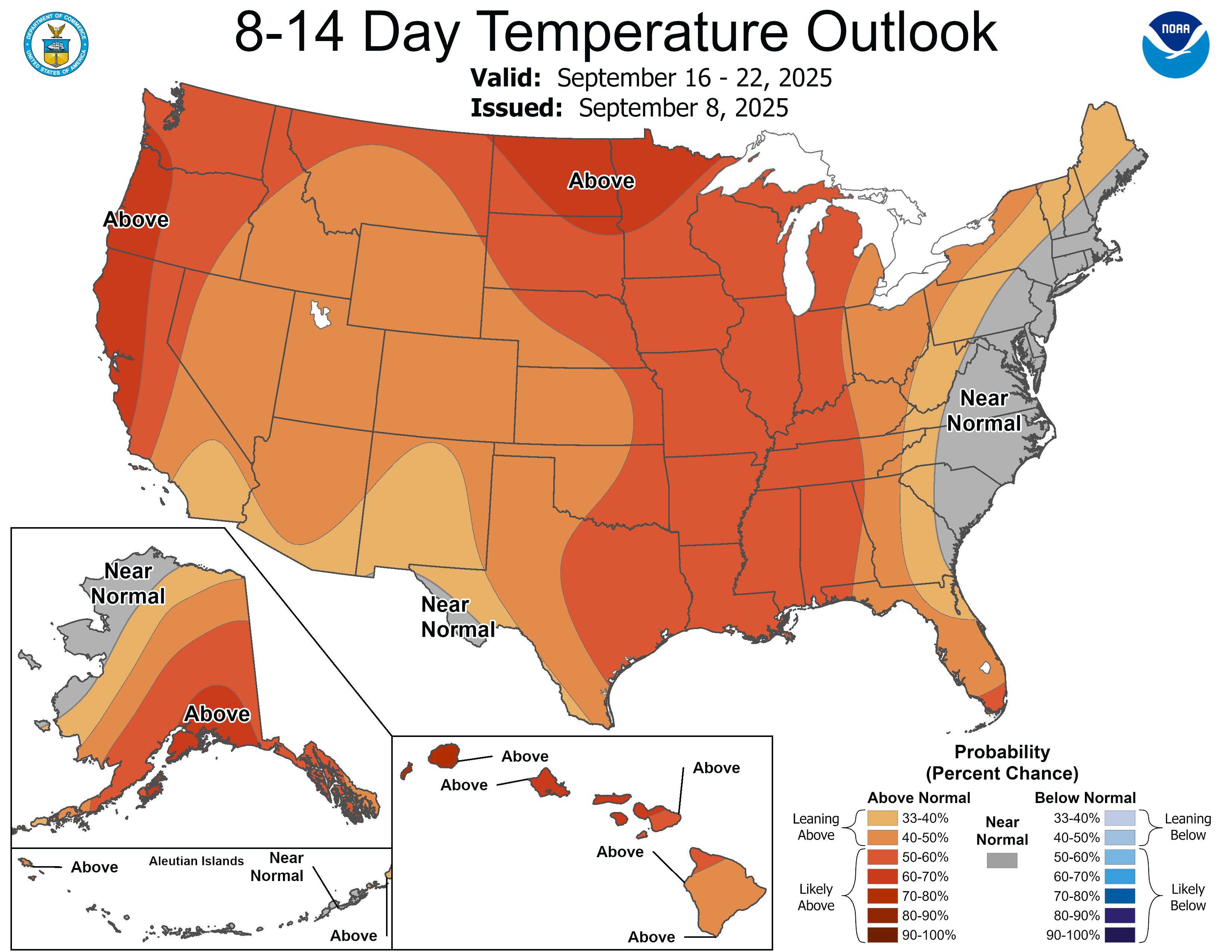
Sure enough, it looks like modeling is trending towards much AN temps during the next 3-4 weeks. We have seen the aforementioned head fake towards cool too many times to count. The one thing in our favor is that E TN is not in a drought. That could help the entire region regardless of drought status as the drought is no forum wide. We will see. Looks like there is another cold front maybe around Sept 20th before modeling really drops the heat hammer. Let's hope that is wrong!
-
-

2025 Atlantic Hurricane Season
Silver Meteor replied to BarryStantonGBP's topic in Tropical Headquarters
I looked up his user name long ago simply out of curiosity. Odd for sure but so what? This website has more "Karens" than Carter has pills. If one finds it so horribly offensive then use the block feature then go and hide in one's "safe space." Heaven forbid one spends time on X and gets introduced to the truly terrifying real world. Long ago it became apparent there are two themes to this website. First, global warming is a religion not to be questioned unless one wants to be ridiculed, and second, anyone to the right of Trotsky is bashed as a racist, bigot, antisemite or nazi which is why the off-topic section was such a disaster (and the antithesis of free speech.) Now, all that said ... I do agree his "Chav speak" (learned a new term today, thank you) is ridiculous and needs to go. This website "American Weather" is not a place for learning lower class British slang. -
Latest seasonals CANSIPS/Euro are showing a nasty trend towards a juiced SER. I think west of the Apps, we still have our chances. It is almost like modeling is overdoing the Nina. Plenty of time for things to change. The daily CFS seasonal is decent until December.
-
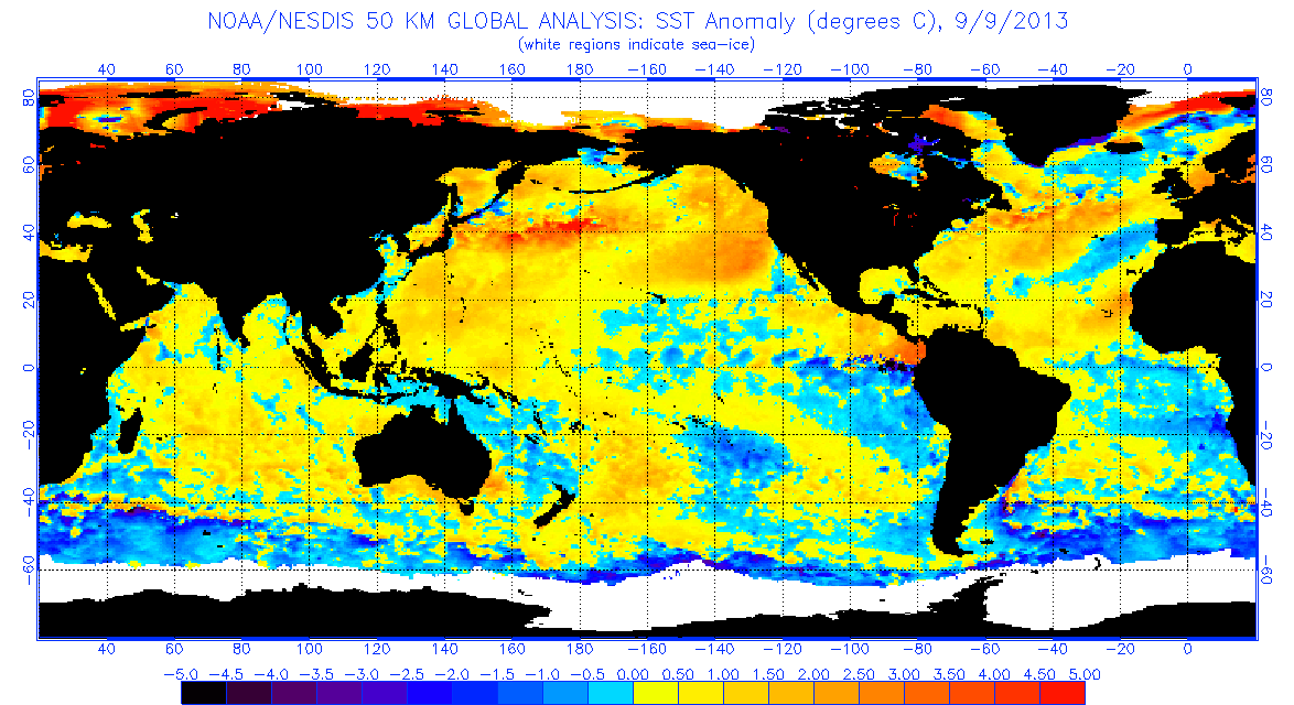
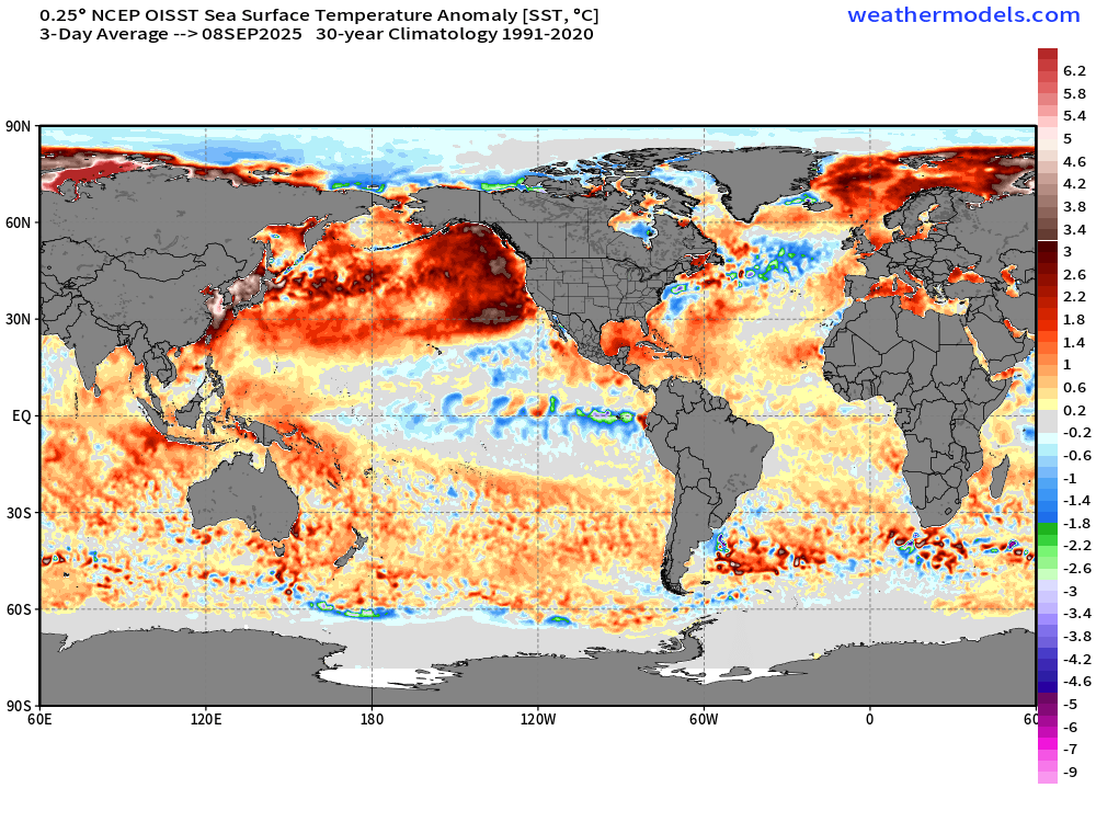
Modeled sst forecasts aside. It's at least slightly interesting to compare the north Pacific layout currently emerging this year, in early September, to the same time period from 2013.
-

2025-2026 Fall/Winter Mountain Thread
BlueRidgeFolklore replied to Buckethead's topic in Southeastern States
I've been here a long time and we've regularly dealt with tropical storm systems. Helene is and hopefully will always be the outlier. I can think back to Bill, Frances, Ivan, Arlene, Dennis, Fred, etc, and never do I remember waking up to such flooding and devastation before the system makes landfall in the Gulf. That's the one image that will always stand out to me with Helene, is the sheer amount of flooding we were already dealing with. Just an unfathomable set of circumstances. -
I can see -EPO. -PNA? Not really
-
5 tornadoes from a single event is pretty damn impressive, even if perhaps a few were the result of lifting up then touching back down several miles later.
-

Central PA Summer 2025
TheClimateChanger replied to Voyager's topic in Upstate New York/Pennsylvania
Officially came in as 3rd driest August on record for the Commonwealth. Ohio, Kentucky and Vermont all had their driest Augusts of record. -
The active MCS pattern we had in mid summer feels like ages ago. We needed a break, but it has been way too long.
-
Occasional Thoughts on Climate Change
TheClimateChanger replied to donsutherland1's topic in Climate Change
The State of New Hampshire had its driest summer on record, although precipitation for the CONUS as a whole came in a bit above normal. -
Occasional Thoughts on Climate Change
TheClimateChanger replied to donsutherland1's topic in Climate Change
Extremely dry conditions noted in many areas. Ohio obliterated the record for driest August. Kentucky & Vermont also had their driest Augusts on record. -

September 2025 OBS-Discussion centered NYC subforum
steve392 replied to wdrag's topic in New York City Metro
It's all about comfort. -
September 2025 General Discussion
TheClimateChanger replied to Geoboy645's topic in Lakes/Ohio Valley
Vermont and Kentucky also had their driest Augusts on record, with Missouri and Pennsylvania coming in 3rd place, and West Virginia in 2nd place. -
September 2025 General Discussion
TheClimateChanger replied to Geoboy645's topic in Lakes/Ohio Valley
Incredible. Easily the driest August on record for Ohio, with a statewide average of 1.01" of rainfall. The previous record was 1.31" in August 1951. - Today
-

2025-2026 ENSO
40/70 Benchmark replied to 40/70 Benchmark's topic in Weather Forecasting and Discussion
Not sure winter averages +PNA per se, but it should be volatile. -
This is the most excited I have been about an upcoming winter since probably 21-22. East based La Niña AND that warm pool off the WC and in the GOA??? I like the look of that.
-
I think that will be dependent on the stratosphere.....seeing potential for a mid winter event, which would trigger a reload.
-
I am starting to think this has the potential to be a big winter in the east, especially New England. I like what I am seeing with the warm pool that has developed just off the pacific NW, that is something that was present in our big +PNA/-EPO winters. There are also signs that the La Niña is going to be east based, which is another point in our favor.
-
44.1 degree low! That is chilly!