All Activity
- Past hour
-

December 2025 Short/Medium Range Forecast Thread
Carvers Gap replied to John1122's topic in Tennessee Valley
And, eh, not terrible...ridging in the Eastern Pac. I thought it might go to crap after this, but the NAO took a shot of the juice and the EPO fired. -
That surface high at 288hrs looks too far east vs 6z.
-

NNE Cold Season Thread 2025-2026
backedgeapproaching replied to Boston Bulldog's topic in New England
Even down here I have had 17 measurable snow events since Mid NOV. I'm sure that number is even higher up there(NVT). It works out to pretty much every other day if you were to average it out, which certainly makes it seems even more snowy as Froude mentioned. Edit: I see Jspin posted above and has 18 events documented, so similar. -
December 2025 Short/Medium Range Forecast Thread
Carvers Gap replied to John1122's topic in Tennessee Valley
I just wanted to introduce my new friend... -

December 2025 regional war/obs/disco thread
The 4 Seasons replied to Torch Tiger's topic in New England
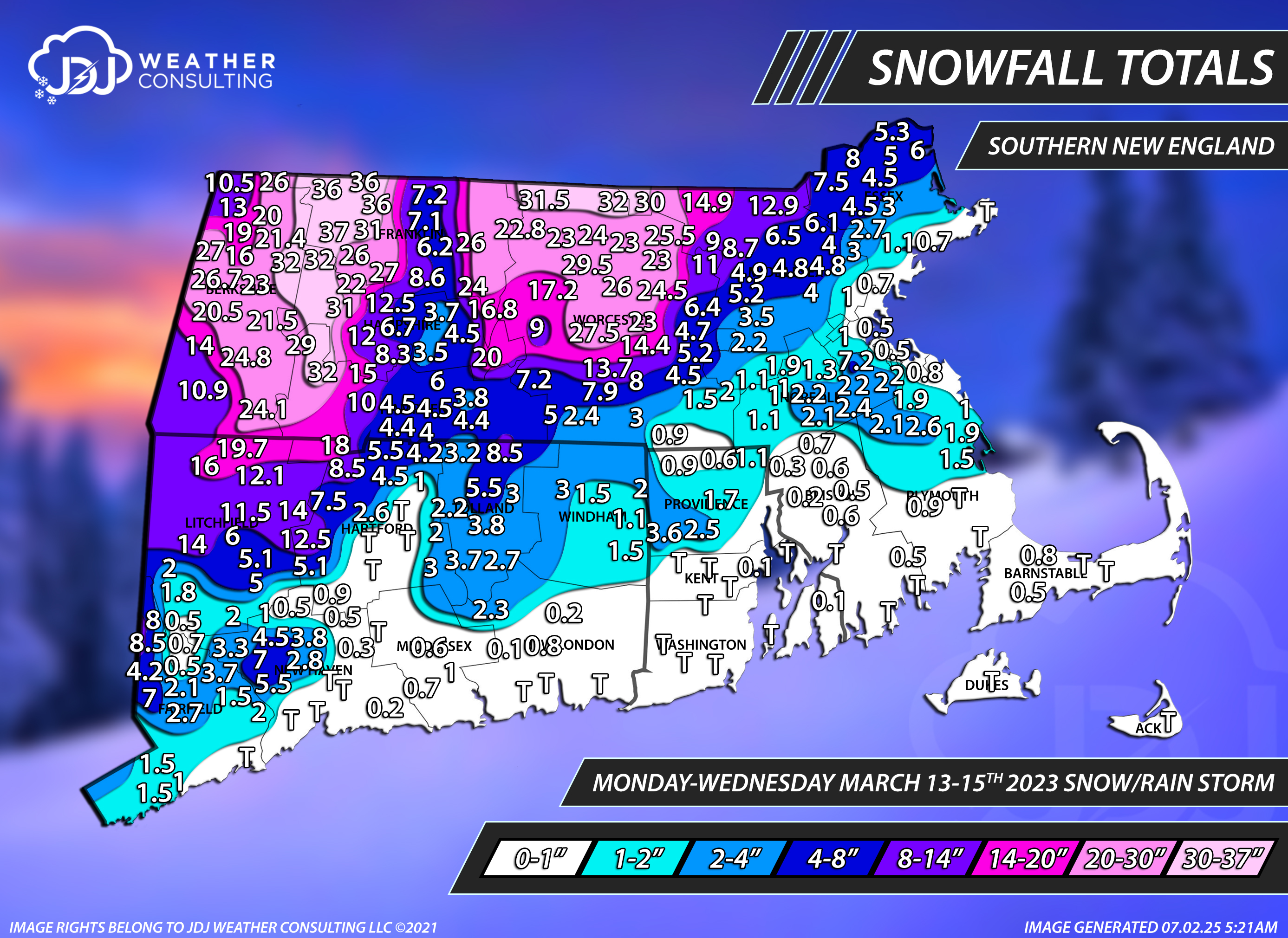
Yep, Northbridge COOP it seems. I noticed that too I'll keep that in mind, i want to redo all these next year and make them more accurate. Some of the COOP sites drive me crazy they are either suspiciously low all the time or suspiciously high and many of them ALWAYS report in whole numbers which also drives me crazy. Like Thomaston Dam, West Thompson Lake, Mount Carmel in CT are always reporting low and round down...to the nearest integer. Back in the day, especially prior to 2007ish and definitely in the 90s all there was was COOP. Another one is Lawrence, MA COOP it's always been insanely low and whole numbers only, while the Gardner COOP has been on the other end of the spectrum. Care to elaborate? Blue Hill, to me, appears like the snow magnet capital of E MA. They seem to jackpot a lot and do extremely well in marginal situations but it's not like their elevation is 1k+ or something, it's only 635 which im sure helps but not to the extent i see some of these storms and totals they have. Like March 4-6th, 2001, Feb 1-3, 2021 or March 13-15th, 2023 are good examples off the top of my head.
-
Might be close. Hingham coop had 5.5” more in 14-15.
-

December 2025 regional war/obs/disco thread
weatherwiz replied to Torch Tiger's topic in New England
The best part IMO is getting data faster -
thats only changed about 40 times already, i suspect the models arent detecting the block this model run as much as they were during the 0z/06z suites. something to keep our eyes on for sure.
-
I’d like that Tuesday deal not to rip well into Canada. It’s going to go north, but would like to avoid this ending in 35F drizzle.
-
If only…. .
-
They had the big announcement yesterday. https://www.noaa.gov/news-release/noaa-deploys-new-generation-of-ai-driven-global-weather-models
-
I think it was just a caveat, but it didn’t seem like it was a big concern.
-
I don't like the wall of summer just to our sw lol
-
-
-Actually, Dec of 1996, indeed, was still another -ENSO strong -PNA that transitioned to a +PNA in Jan after a 1.8+ rise. -Dec of 1999 had a neutral PNA. So, that isn’t in this group. *Corrected for typo…Dec of 1999
-

December 2025 regional war/obs/disco thread
brooklynwx99 replied to Torch Tiger's topic in New England
I've noticed that a lot of the AI stuff does pretty poorly with anomalous Atlantic blocks. they often struggle to get them to develop and wash them out too quickly when they occur. might make sense with the fact that they struggle with anomalous outcomes and they "smooth" things out a bit -
Big cutter on the GFS with temps in the 50's the day after xmas
-

December 2025 regional war/obs/disco thread
weathafella replied to Torch Tiger's topic in New England
Exactly! As events occur, deep learning should ultimately improve the results. -

December 2025 regional war/obs/disco thread
40/70 Benchmark replied to Torch Tiger's topic in New England
The point is to get it operational and garner experience....like a rookie QB. -
Yeah starting to get some model convergence on it. 06z Euro was a little juicier than the 12z GFS but both have it.
-
December 2025 regional war/obs/disco thread
brooklynwx99 replied to Torch Tiger's topic in New England
lol what the hell is the point of that then -
December 2025 regional war/obs/disco thread
weathafella replied to Torch Tiger's topic in New England
The thing about 2014-15 is that 100+ happened in a 6 week period. Absolutely unprecedented for coastal sne. -
00 and 97 I think also went pretty strong +PNA I think but can’t recall if they were negative in December or not. I want to say they were not
-
I like the flurries it shows on the 23rd lol
-
in midtown at this time it's currently 44 degrees partly sunny! Any snow chances for Christmas ?