All Activity
- Past hour
-

Central PA Fall Discussions and Obs
Blizzard of 93 replied to ChescoWx's topic in Upstate New York/Pennsylvania
I hope that you had a great day at Elizabeth Farms! We took our 2 daughters there for around the last 8 years. They have a nice set up there to see Santa & get a good photo that often became our Christmas card. We would then take a ride on their horse drawn wagons that take you out to the tree cutting area. We just enjoyed the ride, even though we’ve always had an artificial tree, lol. Then we’d get some cocoa in their gift shop while we warmed up. Our kids always picked out a new ornament for our tree each year. Enjoy it my friend, because time flies! My daughters are now 12 & 14 and this is the first year that we did not go to Elizabeth Farms because they both now have out grown going to see Santa! -
God bless you and your family[emoji120] .
-
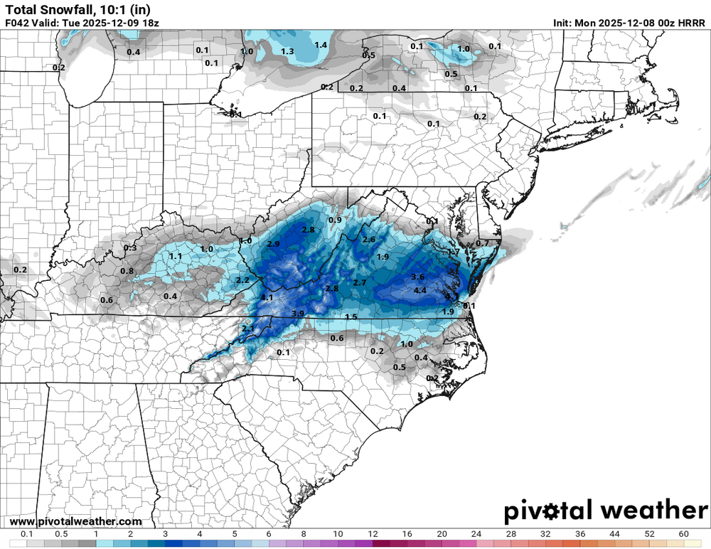
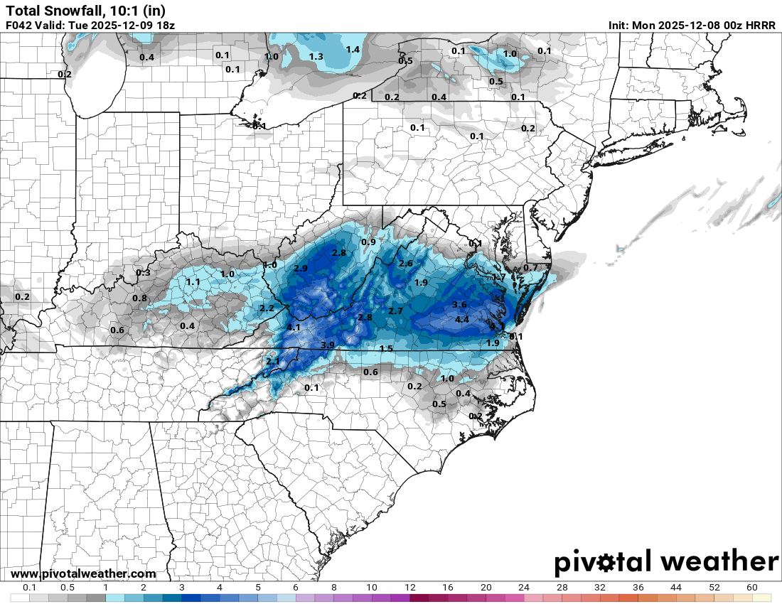
0z HRRR - a bit of an increase overall from 18z but like the NAM and 3k especially in the south side of the RIC metro
-

E PA/NJ/DE Winter 2025-26 Obs/Discussion
Birds~69 replied to LVblizzard's topic in Philadelphia Region
Barely rings a bell? Probably because my parents never watched channel 3... -

Richmond Metro/Hampton Roads Area Discussion
migratingwx replied to RIC Airport's topic in Mid Atlantic
AKQ just upgraded RIC metro to a warning. URGENT - WINTER WEATHER MESSAGE National Weather Service Wakefield VA 917 PM EST Sun Dec 7 2025 VAZ061-068-069-081-082-513>516-081030- /O.UPG.KAKQ.WW.Y.0011.251208T1100Z-251209T0300Z/ /O.NEW.KAKQ.WS.W.0006.251208T1100Z-251208T2300Z/ Cumberland-Amelia-Powhatan-Prince George (including Hopewell and Petersburg)-Charles City-Western Chesterfield-Eastern Chesterfield (Including Col. Heights)-Western Henrico (Including the City of Richmond)-Eastern Henrico- 917 PM EST Sun Dec 7 2025 ...WINTER STORM WARNING IN EFFECT FROM 6 AM TO 6 PM EST MONDAY... * WHAT...Snow expected. Total snow accumulations between 2 and 4 inches with localized amounts in excess of 4 inches possible. * WHERE...Portions of central, east central, and south central Virginia. * WHEN...From 6 AM to 6 PM EST Monday. * IMPACTS...Plan on slippery road conditions. The hazardous conditions could impact the Monday morning and evening commutes. PRECAUTIONARY/PREPAREDNESS ACTIONS... If you must travel, keep an extra flashlight, food, and water in your vehicle in case of an emergency. Call 511 for road information. && $$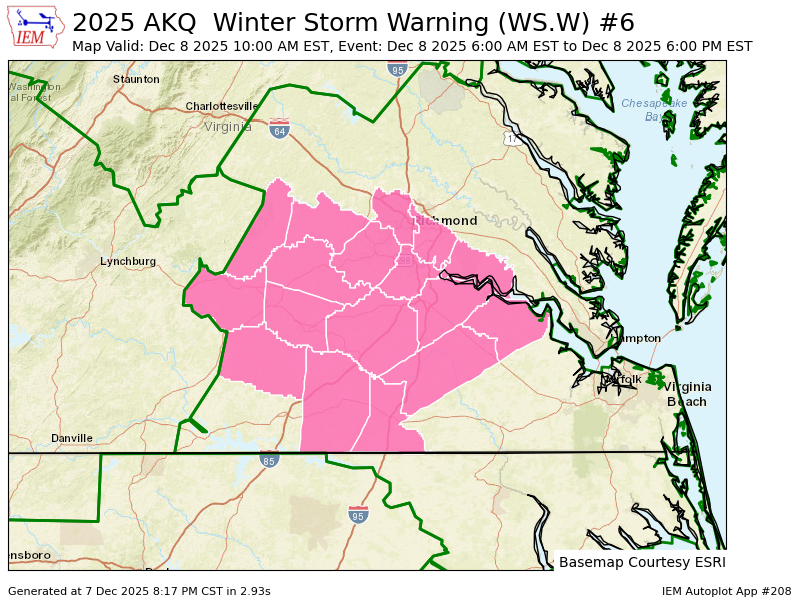
-
Winter Storm Warning was a surprise… I think first one i’ve had in awhile due to school.
-

Richmond Metro/Hampton Roads Area Discussion
mikeeng92 replied to RIC Airport's topic in Mid Atlantic
Upgraded to winter storm warning ! -

E PA/NJ/DE Winter 2025-26 Obs/Discussion
Ralph Wiggum replied to LVblizzard's topic in Philadelphia Region
Bill Kuster mid 70s Lamaine was late 80s early 90s. https://youtube.com/watch?v=LBiU_C2hwag&si=PdWhr-JTXffW4rqW -

Dec 6-7th (It's not a clipper) Clipper
michsnowfreak replied to Chicago Storm's topic in Lakes/Ohio Valley
There have been some front end winters (hello 2000-01) but certainly after Christmas is often when a lot of the fun is. -
much more excited for tomorrow than i was for friday
-
3k NAM is lighter with precip but still a step up from 18z.

-
Also, we have to give the ICON a lot of credit on this one. There were a few runs a couple days ago where it was the ONLY model showing accumulating snow.
-
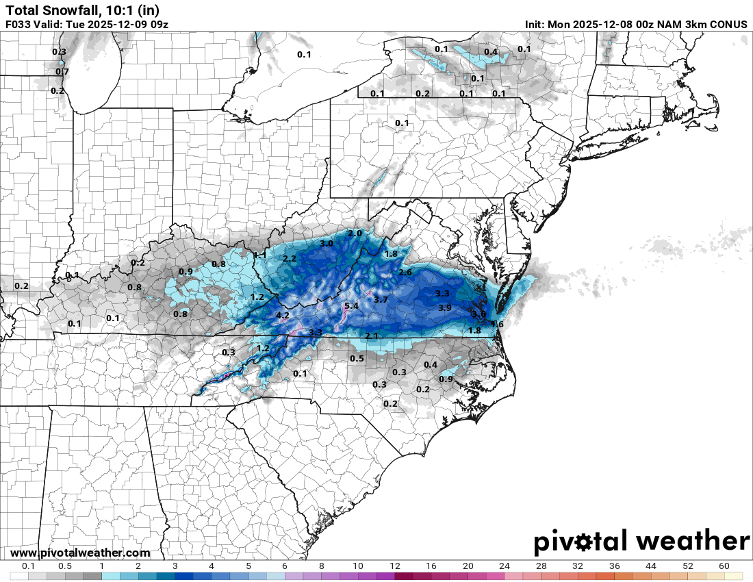
Hi Res Nam. Should be at least some coatings in northern NC. If a band sets up maybe an inch or 2.
.thumb.png.48b5eca9aebf10c05abbd2b2eae8b74e.png)
-
Central VA generally doesn't do well with anything other than an already developed low moving into cold air. For example, the second Feb 2010 storm was either a total whiff or a light event here. That's why I'd, based on pure semi-educated guess, lean towards a lower total. The precip has to develop mostly over us due to the coastal/ULL. I'd love to be proven wrong though lol
-
Yes it is
-

The Monday wintry event potential (12/8/25)
PackGrad05 replied to GaWx's topic in Southeastern States
Both the NAM and HRRR want to redevelop moisture across central NC around 7-10PM -
Better go back to Farmville I bet they get 4-6
-
00z NAM is going to absolutely pummel RIC especially south side of RIC metro. It also keeps precip around for longer
-
Lynchburg to Roanoke will do well. Might be a couple 6-7" spots
-
This means a lot thank you
-
I have thought all along we couple be looking at the end if DEC or early JAN.
-
Do the best you can during these difficult times. Don’t lose hope. Both of you are in my thoughts and prayers.
-
There will be a warmup I think but hopefully short-lived.
-

December 2025 regional war/obs/disco thread
40/70 Benchmark replied to Torch Tiger's topic in New England
What? I don't think I'm one to jump prematurely...all I said was significant snow likely around mid month....to me, "significant " is like greater than 3".


.png.16b432b0a3bdcaf830923ced5cb65820.png)


