All Activity
- Past hour
-
Wouldn't be surprised to see some small hailers tomorrow
-
What’s the over/under for qpf? This seems like a less than ideal setup. It doesn’t even feel humid out rn.
-
ALWAYS
-

E PA/NJ/DE Spring 2026 Obs/Discussion
JTA66 replied to PhiEaglesfan712's topic in Philadelphia Region
So our wet Wednesday has morphed into a decaying line of showers zipping through overnight. Just make you appreciate we got anything frozen at all this past winter. 66F -
So, we are doing that skipped spring thing then, that sucks.
-
Yesterday was one of the few sunny/light wind days we’ve had. I want more of those.
-
(002).thumb.png.6e3d9d46bca5fe41aab7a74871dd8af8.png) I have compiled the climate averages based on the NOAA calculation of Climate Normals for the philly burbs of Chester County PA for a full year with 30 year averages updated every 10 years. The first base period was from 1901-1930 with our most recent being the current climate base of 1991-2020. You can see our warmest base climate normal occurred back in the 1921-1950 and 1931-1960 periods.
I have compiled the climate averages based on the NOAA calculation of Climate Normals for the philly burbs of Chester County PA for a full year with 30 year averages updated every 10 years. The first base period was from 1901-1930 with our most recent being the current climate base of 1991-2020. You can see our warmest base climate normal occurred back in the 1921-1950 and 1931-1960 periods.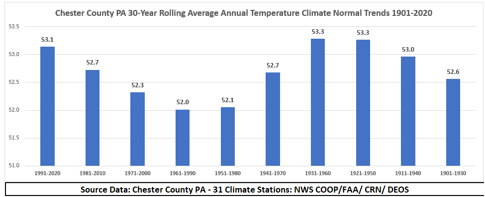
-
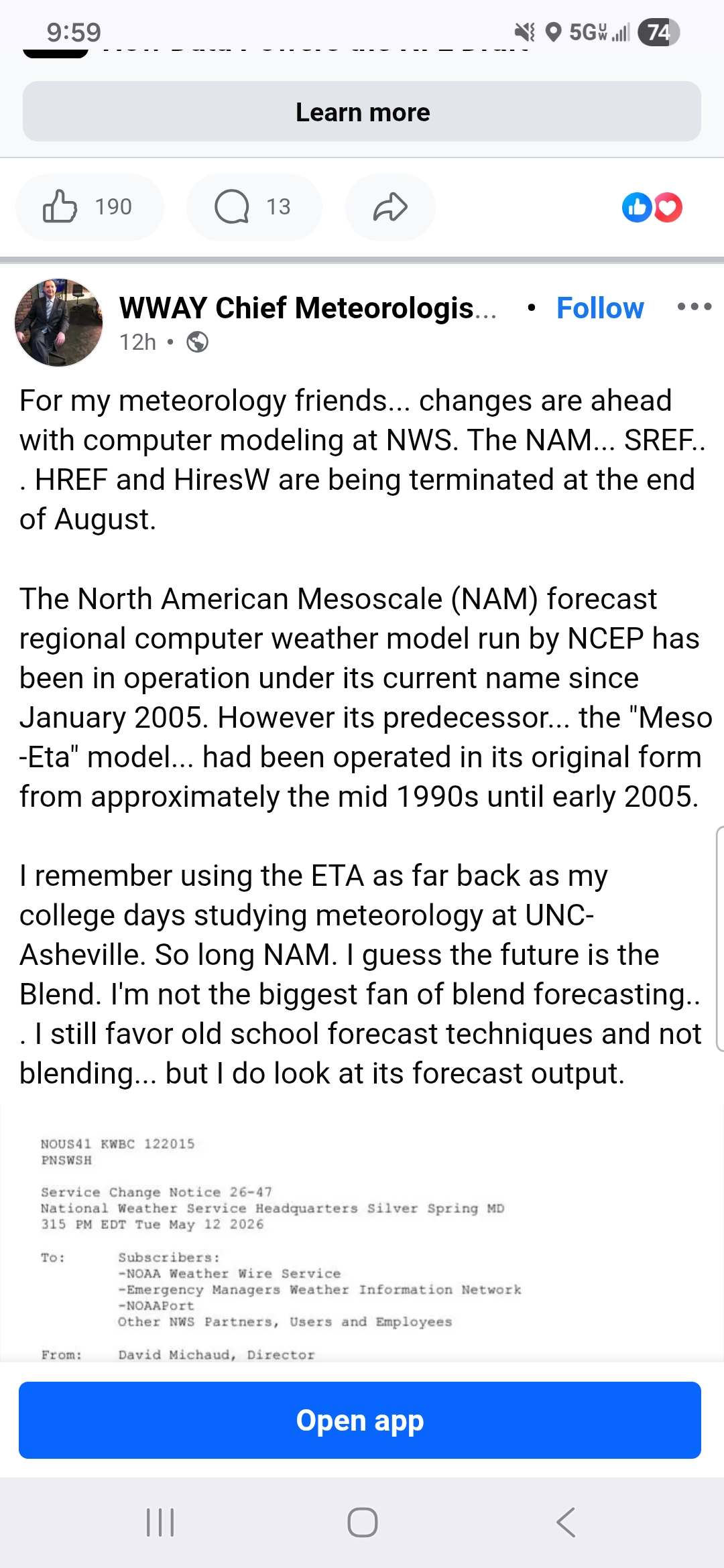
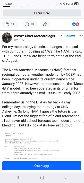
Losing the 3k is unfortunate. In the few times looking at the RRFFFSSSS, the 3k was much more "correct". Losing the acuracy of mixing with be a real forcasting crunch.
-
Central PA Spring 2026 Discussion/Obs Thread
ChescoWx replied to Voyager's topic in Upstate New York/Pennsylvania
I have compiled the climate averages based on the NOAA calculation of Climate Normals for the philly burbs of Chester County PA for a full year with 30 year averages updated every 10 years. The first base period was from 1901-1930 with our most recent being the current climate base of 1991-2020. You can see our warmest base climate normal occurred back in the 1921-1950 and 1931-1960 periods.
-
E PA/NJ/DE Spring 2026 Obs/Discussion
ChescoWx replied to PhiEaglesfan712's topic in Philadelphia Region
I have compiled the climate averages based on the NOAA calculation of Climate Normals for the philly burbs of Chester County PA for a full year with 30 year averages updated every 10 years. The first base period was from 1901-1930 with our most recent being the current climate base of 1991-2020. You can see our warmest base climate normal occurred back in the 1921-1950 and 1931-1960 periods.
-
It better come with the wet or my yard is going to be Arizona by July.
-
And besides losing the joy of a happy hour NAMing, the NAM is/was the best for mixing lines as we saw last winter. We’re gonna get surprised by pingers.
-
Another big source for error too comes from rounding. We only touched upon this briefly but it's an interesting concept to think about - but thinking out loud here, I guess you can consider something like rounding human error. At first glance, something like rounding may not seem like a huge deal but when you're dealing with the computation of tens of thousands (maybe even in the hundredths of thousands or millions?) of equations, errors due to rounding are going to add up quickly and this could very well be a large source for error when you start getting out to say 3 days. You could also argue that modeling is rather accurate out to 15-16 days because when you're getting that far out in time what are your two options really? Modelling and climatology. I never knew this until this was discussed briefly as well in my class, but the reason the GFS is ran to 384 hours is because that is about the cut-off of when modeling has an advantage over climatology. After that time climatology tends to outweigh modelling. Interesting stuff
-
You could almost predict that the separate layer of interpretive modeling wouldn't even be necessary. A lot of the cause behind their creation was/is to cure both error that's known, but anticipation and suspicion, upon each model run. But therein is the source of the human error...right? In a future whence QC modeling cores are like ...terrifyingly accurate out to 17 some odd days, the interpretations become just a veneer technology layer at the output end of each cycle - more for readability. Yeah ..that would soup to nuts be a bad day for weather forecasters as a profession, wouldn't it?
-

2026-2027 Strong/Super El Nino
GaWx replied to Stormchaserchuck1's topic in Weather Forecasting and Discussion
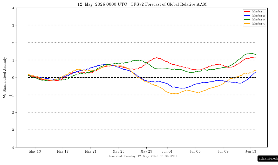
Latest CDAS suggests resumption of warming started: this is an approximation of ONI but with a slight cold bias (this implies RONI of ~+0.5)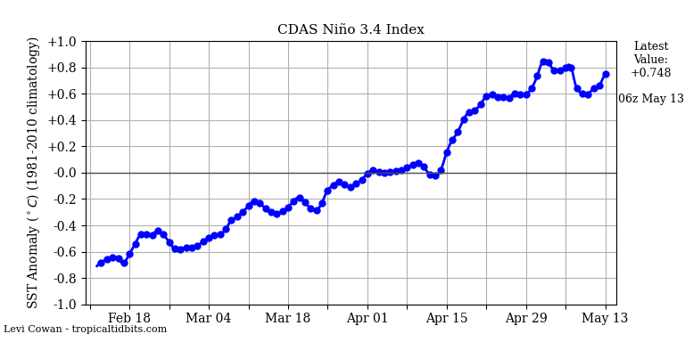
-
I know you have stated this over the years and it's something I believe in as well, but introduce quantum computing and improve model initialization schemes and we will see forecast accuracy improve drastically - and not just accuracy but we probably see less wavering. But who knows...maybe this is a nice theory lol
-
I take everything with a grain of salt, but I think I heard someone mention it in here in the past as well....im gonna miss being NAM'd.... in both good ways and bad lol
-
2026-2027 Strong/Super El Nino
GaWx replied to Stormchaserchuck1's topic in Weather Forecasting and Discussion
Latest CFSv2 ens AAM prog: nothing notable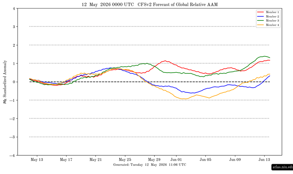
-
Yeah, but those are interpretive tools, after that fact. Ha! Interpretative tools like that compendium you gave there, they are created by humans. You know what that means ... it means we're likely to introduce a whole new layer of potential error. LOL Drool humor aside ... one might suspect general error improves, in step, with/if the raw data source improvement; because obviously interpretive algorithms are tapping into less error to begin with...etc.
-
So now what do we say when the RRFS crushes us with wind?
-
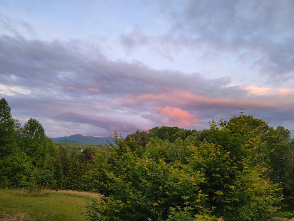
A beautiful sunset the other evening. Sent from my SM-G998U using Tapatalk
-
This week has been beautiful. Highs in the 60s and lows in the 40s.
-
Part of the degrading in forecasting too is all of these stupid products that exist. Model snowfall maps, Freezing Rain Accumulation maps, Supercell Composite Parameter, Significant Tornado Parameter, the stupid hazard type at the bottom right of the SHARPpy forecast soundings, maybe throw updraft helicity swaths in here too
-
Looks like tomorrow's rain event is fizzling again. Maybe .25"
-
The dry period has been nice after weeks of rain, but after 2+ weeks of nothing we need rain again. Fortunately, we should get it this weekend into early next week.