All Activity
- Past hour
-
you mean the 12z ICON from FRIDAY (this is an old run of the ICON)
-
essentially this. just take a look at ens guidance currently, and the range that still exists at this time. some ens have a non-event south of the wi/il border, some favor cycloneville for, others favor the mchenry area crew, and there are numerous that favor the metro.
-
It's not over, at least potentially... if the NA look materializes and we can time a wave.
-
Everything’s working back to that ICON solution from Friday. Which Chicago Storm has been quietly riding.
-
make sure you change it back to winter after this event
-
Forecast for the shore my way bombing. Just FL/--SN. Banding off the lake staying out on the Lake down into WI.
-

Central PA Spring 2026 Discussion/Obs Thread
canderson replied to Voyager's topic in Upstate New York/Pennsylvania
To today - strong east winds are so rare -
Central PA Spring 2026 Discussion/Obs Thread
canderson replied to Voyager's topic in Upstate New York/Pennsylvania
I’ll have to go read that new thread I guess. C MD down into the Carolinas - especially S of MD is in the big time tornado crosshairs. -
seems more believable
-

Central PA Spring 2026 Discussion/Obs Thread
Itstrainingtime replied to Voyager's topic in Upstate New York/Pennsylvania
A severe weather expert met in the MA sub (high risk) still has a few reservations about the extent and level of severe tomorrow. I hope his concerns play out. -
This potential severe outbreak has inspired a profile pic change from Winter to Spring mode. I think I took that one back in 2015 from the end of my driveway. I will be driving from work northeastward towards home late afternoon tomorrow. I may adjust the timing based on actual conditions.
-
Because of what it showed. Euro is also showing blocking. We will see 1 more snow event.
-
Even if it does, it will be an all-rain event. Temps are going to be in the 50s.
-
I think people are underestimating the ability for any open warm sector storms to blow up and start spinning. 700mb forcing for ascent on this event is absolutely absurd and there are some other subtle features (confluence band?) that could help OWS convection as well.
-
-

3/16/26 Severe Weather Event Thread (Day 2 MOD Risk)
NorthArlington101 replied to Kmlwx's topic in Mid Atlantic
With the new rating system you can more easily have a wind-driven high risk. High risk is less likely to equal a massive tornado day… same with moderate. I still don’t think we need a high risk upgrade, but you could probably justify it tomorrow if we uptrend even slightly. -
12z GEFS seems overdone
-

3/16/26 Severe Weather Event Thread (Day 2 MOD Risk)
Warm Nose replied to Kmlwx's topic in Mid Atlantic
Ground is wet. Winds are gonna be strong. Not a great recipe. I have 80-100-foot trees on three sides. -
High risk
-

3/16/26 Severe Weather Event Thread (Day 2 MOD Risk)
SomeguyfromTakomaPark replied to Kmlwx's topic in Mid Atlantic
What’s the h word? -
Central PA Spring 2026 Discussion/Obs Thread
canderson replied to Voyager's topic in Upstate New York/Pennsylvania
Caveat seems to always applies up here though - cape isn’t that high. If we don’t clear out and get a few rounds of early afternoon showers and even t-storms it realy ramps down the ability for a qlcs to sustain itself here. -
In my mind right now - the "floor" is probably something like a semi-solid squall line of widespread 50-60mph winds with the synoptic winds behind it. Still could yield a lot of damage reports which could verify a high percentage (even if not high CIG) I suppose. I guess I could see a scenario where they pull the trigger on a high - but I agree with others that it would not be before 1630z tomorrow - and if they did it we'd potentially see one of those mesoscale discussions a couple hours before the actual outlook update to say "CATEGORICAL UPGRADE" I still think this is a moderate risk through and through - but can't deny some of the dynamics at play. If people "want" a high risk just for the wow factor - the messaging has already been intense enough all weekend to get the word out.
-
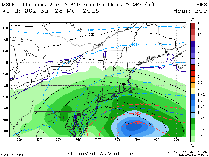
BOX going big or go home with widespread 2-3” rainfall amounts in SNE
-
I’d rather not widespread severe and risk having trees fall on our house.
-
Yeah, Wausau seems to be the cutoff for true winters in WI. I go up there a few times each winter for snowmobiling and relaxation. The gateway to the northwoods, a beautiful area especially when you get into the forests north of town.


