All Activity
- Past hour
-

September 2025 OBS-Discussion centered NYC subforum
nycwinter replied to wdrag's topic in New York City Metro
so above normal for the month in the west and northeast that i find hard to believe.. -
we take! I wont try to wishcast this one though
- Today
-

September 2025 OBS-Discussion centered NYC subforum
Volcanic Winter replied to wdrag's topic in New York City Metro
I honestly can’t believe how the end of summer has played out, and seemingly the beginning of fall. For me, it doesn’t get better this time of year. It’s been absolutely beautiful. I haven’t been around much but I’m coming back, I just have to catch up in a few threads for a while. I’m growing excited to see where the rest of this year takes us, into next year. -
 A lot of disparity in the forecasts this month. Even the CPC's outlook released today looks crazy based on how the 1st half of the month will likely turn out (especially in the NW).
 -
 I sort of expect a mid-month reversal from west/warm east/cool to the opposite, but perhaps the west will hold on to warmth anyway, going to go with 1.0 _ 1.0 _ 1.0 _ 1.5 _ 1.5 _ 1.5 _ 2.0 _ 2.0 _ 2.0
 -
Complete fantasy land but it’s not often you see a model run with a left hook into NE
-
DCA: -2.6 NYC: -2.0 BOS: -1.6 ORD: -3.5 ATL: -0.8 IAH: -0.1 DEN: +0.5 PHX: +0.4 SEA: +3.0
-
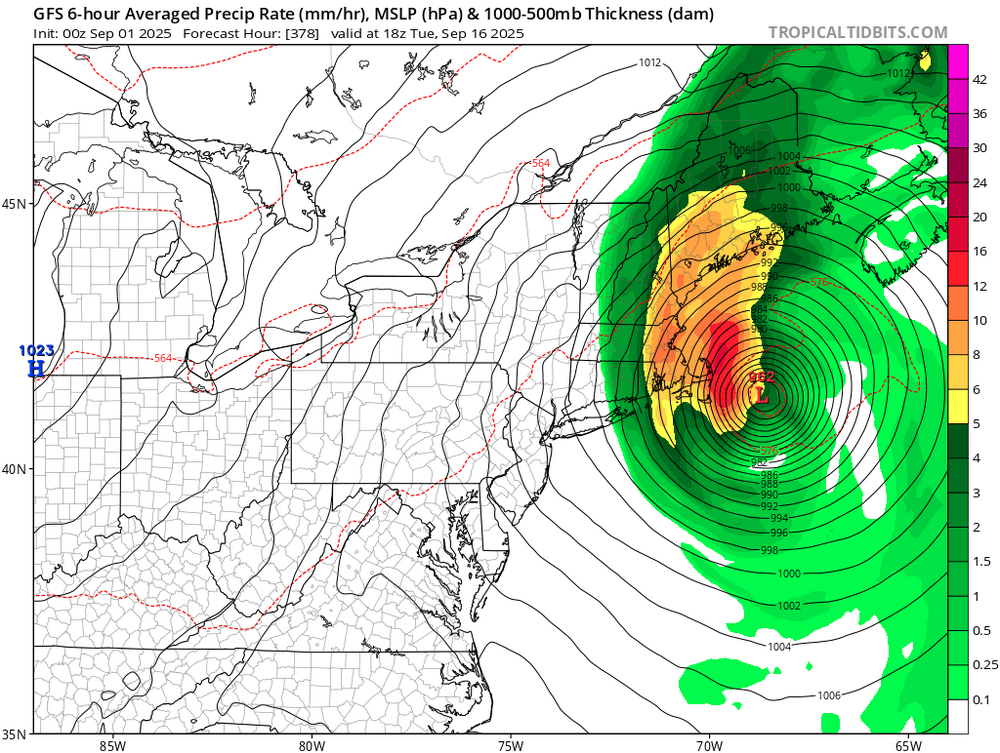
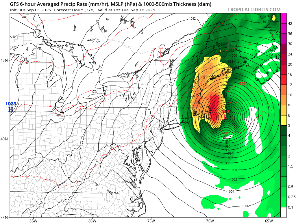
Some 0Z models: -GFS has a MH that goes E of Bermuda but then gets blocked by a big high -Like for the 12Z, the 0Z UKMET text has no TC. I’ll see how the maps look when they come out. The 12Z was kind of wacky with two weak lows. -CMC again has a possible TD in the E MDR that weakens later. -0Z JMA goes out only 72 hours. -So, Icon, GFS, UKMET, and CMC are fairly similar at 0Z to their respective 12Z runs. Next up is the all-knowing Euro!
-

2025 ENSO/Winter Speculation
Prismshine Productions replied to 40/70 Benchmark's topic in New England
What about the interior then? Sent from my SM-S166V using Tapatalk -

September 2025 OBS-Discussion centered NYC subforum
MJO812 replied to wdrag's topic in New York City Metro
Happy meteorological Autumn -
Happy meteorological Autumn
-
 DCA: -2.5 NYC: -1.6 BOS: -0.9 ORD: -2.6 ATL: -0.8 IAH: +05 DEN: -0.6 PHX: +0.7 SEA: +1.9
 -

Fall/Winter Banter - Football, Basketball, Snowball?
Mr Bob replied to John1122's topic in Tennessee Valley
Every FSU fan too!!!! -
-

E PA/NJ/DE Summer 2025 Obs/Discussion
RedSky replied to Hurricane Agnes's topic in Philadelphia Region
44.4F Labor Day morning -
I agree, but the distance between “official” reference points across the northwestern part of Massachusetts leaves a lot of gaps.
-
We multiple stations across W MA
-
Even if we did, I'll take my chances on more snowfall than last year.
-
2025-2026 ENSO
Stormchaserchuck1 replied to 40/70 Benchmark's topic in Weather Forecasting and Discussion
When I was researching 10mb events, about Sept 25 is when bigger things start to occur. In late Sept/Oct the correlation with warm Stratosphere to -NAO is actually +60 days! So a warming event would predict a -NAO in late November or December. Cold Stratosphere/+AO is +0 days, right to the surface, as it is the whole cold season. -
We shall inevitably revisit this post again on Halloween, Christmas and perhaps Valentine’s Day and get a good chuckle out of it. At least the a/cs get a respite for the time being.
-
2025-2026 ENSO
Stormchaserchuck1 replied to 40/70 Benchmark's topic in Weather Forecasting and Discussion
August finishes the 13th straight month with +SOI, albeit weak -
Tuesday, September 16, 2025 Tornado Emergency remains in effect for northern Baltimore City and central Baltimore county until 5:45PM EDT. At 5:32PM a confirmed large and destructive tornado was located near Pikesville, MD moving northeast at 50 mph. Locations impacted include Pikesville, Stevenson, Brooklandville, Mays Chapel, Cockeysville, Hunt Valley, Ashland, Timonium, Phoenix, Jacksonville. This tornado has a history of producing catastrophic damage across parts of Montgomery and Howard counties in Maryland. This is a life-threatening situation. Everyone in the warned area must be underground in a basement until the storm passes.
-
Crisp unsummer-like weather continues. Happy Meteorological/Climatological Fall.
-
Seriously? Okay, come on down, to Austin, Texas! We got all the Summer you can handle!
-
I am so damn jealous its not even funny. We've had 75 dews for months. I have gotten so accustomed to 98/75 that I kick back on a plastic chair in the back porch in the shade and fall fast asleep while I am supposed to be watering mom's plants. I am so used to humid weather, that at night while delivering I often have the windows down, in 78/74 conditions.


.thumb.png.4150b06c63a21f61052e47a612bf1818.png)


