All Activity
- Past hour
-
Think I can hear distant thunder from the storm over south Baltimore
-
Same here. Roasting
-
I believe there is data that points to that. Especially with overnight lows and dewpoints...
-
No rain here, but we have severe storm moving South at 5 mph near Dunalk, MD . * Severe Thunderstorm Warning for... Southeastern Baltimore City in northern Maryland... Northeastern Anne Arundel County in central Maryland... Southeastern Baltimore County in northern Maryland... * Until 600 PM EDT. * At 531 PM EDT, a severe thunderstorm was located over Dundalk, or over Sparrows Point, moving south at 5 mph.
-
The average dewpoint for July/August for most parts of SNE is between 61-64 degrees. AN dewpoints (upper 60's/low 70's) on Tuesday, Wednesday of this week, then next Monday, Tuesday, Wednesday of next week. Otherwise average to below average dewpoints. Run the Euro and take a look. GFS similar. Still looks like above normal temps most of the time, with warm downs to average in between. Also looks dry like you said, except for a couple of days where t-storms are possible. This isn't a hot vs cold thing, its a discussing the forecast thing...
-
High of 92. Heat’s definitely back.
-
 July DCA _ NYC _ BOS ___ ORD _ ATL _ IAH ___ DEN _ PHX _ SEA 1.5 1.5 1.0 1.0 1.5 2.0 1.0 2.0 1.0
 -
The event is extremely unlikely but not impossible. Plus early 80s was peak aerosol pollution, we had capped climate change through air pollution. Then there is also natural variability.
-
We need a Hurricane to stir things up
-
Summers feel like they have become more and more humid over the past decade or so. I’m sure Brian or someone would have data showing it one way or the other.
-
The bigger story will be the dews . Hopefully at least some storms .. It’s gotten uber Stein recently . Had to start watering
-
I expect highs 83-93 daily over the next 6 weeks with a few more intense heat waves mixed in , maybe on occasional cooler day here and there.
-
Hopefully we get past the hottest part of the year without any brutal temps
-
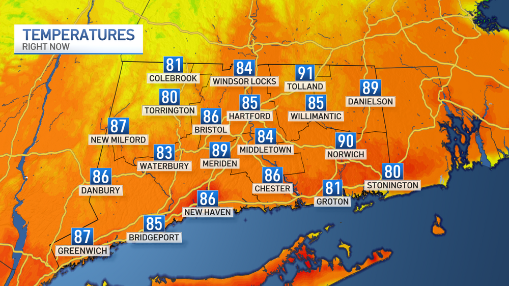
Your minutes away from Tolland where it's 91 and the hottest temp in the state...
-
Yup. And it was a bit below that AWT. lol (just a degree). Someone else thought 88 for KFIT.
-
West and Midwest is best for heat like I said average to above and below at times.. doesn't look hot all the time to me
-
Today's min of 77F at NYC was 1F off the 2021 record which replaced 1870 (77F) so it was tied second warmest for the date.
-
Eps average is 57 at the end of the run here Edit. For dews not temps
-
Flash Flood Statement National Weather Service Mount Holly NJ 502 PM EDT Sun Jun 29 2025 DEC005-300015- /O.CON.KPHI.FF.W.0022.000000T0000Z-250630T0015Z/ /00000.0.ER.000000T0000Z.000000T0000Z.000000T0000Z.OO/ Sussex DE- 502 PM EDT Sun Jun 29 2025 ...FLASH FLOOD WARNING REMAINS IN EFFECT UNTIL 815 PM EDT THIS EVENING FOR SOUTHEASTERN SUSSEX COUNTY... At 502 PM EDT, Doppler radar and automated rain gauges indicated thunderstorms producing heavy rain across the warned area. Between 1 and 3 inches of rain have fallen, with the greatest totals near Indian River Bay and Indian River Inlet. The expected rainfall rate is 1 to 2 inches in 1 hour. Additional rainfall amounts of 0.5 to 1 inch are possible in the warned area. Flash flooding is ongoing or expected to begin shortly. HAZARD...Flash flooding caused by thunderstorms. SOURCE...Radar and automated gauges. IMPACT...Flooding of small creeks and streams, urban areas, highways, streets, and underpasses as well as other drainage and low lying areas. Some locations that may experience flash flooding include... Millsboro, Millville, Long Neck, Ocean View, Indian River Inlet, South Bethany and Dewey Beach.
-
Florida mode today
-
It’s seems it’s a very humid look with 88-93 type stuff. Which is coveted
-
I said 82 to 84 for you.
-
The only comparable snowstorms I can think of occurred in the 1870s. I wonder what caused that snowstorm and cold so many decades after the planet had already started to warm?
-
The Euro weeklies don't support an overall cooler look if you want to go long term. Mostly AN with some short stretches of Normal. Every 7 day anomaly is AN for the entire month... That being said also no 100+ degree heat on the horizon either... for now...
-
90/66 Heat index of 93 in Lindenhurst right now


