All Activity
- Past hour
-
You'll know it's October when we have out annual fall heat ridge and you're carving pumpkins in 90 °F heat.
-
I’m not sure, but just last year we had two majors hit Florida in ~10 days of each other.
-

2025 Lawns & Gardens Thread. Making Lawns Great Again
Damage In Tolland replied to Damage In Tolland's topic in New England
Banner year for them here. I must have 50 or more that have either been picked or growing off of just 3 plants. On the ground https://imgur.com/a/xleJVfO -

2025-2026 ENSO
donsutherland1 replied to 40/70 Benchmark's topic in Weather Forecasting and Discussion
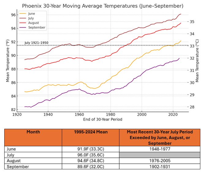
August has grown hotter and drier in Phoenix. It is also warmer than July was in the past. That includes extreme heat. August 2020-2025 has had more high temperatures of 115 or above than the entire August 1895-2019 period. This year’s monsoon season is also off to a dismal start in the Phoenix area. -
i also have a rock that keeps panthers away
-
Yeah, locations that didn’t have the flooding have been very dry this summer. My area just east of HVN has had the 11th driest June 1st through August 6th. Most of the grassy areas are brown around here. It has also been the 2nd warmest summer over the same period. Very uneven rainfall patterns across the area during recent years. Last few years have been an all or nothing type of rainfall patterns. Where we alternate between drought and flash flooding. Light rains don’t do much in such a warm climate since the warmth quickly dries things out after the light rains. A cooler summer can do OK with less rainfall. Time Series Summary for NEW HAVEN TWEED AP, CT Driest June 1st through August 8th Click column heading to sort ascending, click again to sort descending. 1 2000-08-06 1.80 60 2 1957-08-06 2.70 0 3 2017-08-06 3.01 3 4 1966-08-06 3.16 0 5 2016-08-06 3.44 0 6 2014-08-06 3.46 1 7 1954-08-06 3.49 0 8 1976-08-06 3.76 0 9 1949-08-06 3.86 0 10 2022-08-06 3.88 0 11 2025-08-06 4.15 0 Time Series Summary for NEW HAVEN TWEED AP, CT Warmest June 1st through August 8th Click column heading to sort ascending, click again to sort descending. 1 2024-08-06 76.1 0 2 2025-08-06 75.1 0 3 1977-08-06 74.9 31 4 2022-08-06 74.5 0 - 2020-08-06 74.5 2 5 2010-08-06 74.4 0 6 2019-08-06 74.0 0 7 2013-08-06 73.9 0 8 2012-08-06 73.5 0 - 2008-08-06 73.5 0 9 2023-08-06 73.1 1 10 2011-08-06 72.9 0
-
I wanna say ... 1999? there were a couple of obnoxious warm departures between Halloween and January 1 that late autumn/early winter. The SE ridge had become proxy over the flow east across the continent, and each time it lasted a week. I remember consecutive days in the upper 60s balm, with no leaves on the trees and sweating streets. One of them had a couple days to 74. Something like that, tho not as extreme took place in 2006, too.
-
Mountain West Discussion
mayjawintastawm replied to mayjawintastawm's topic in Central/Western States
We've been able to open windows and turn a big fan on most nights, but last night the temp went down to 68 at 11 PM but rose after that, 73 at 6 AM. Stuffy. One of many reasons I don't live in AZ. -
i'm gonna be in boston in two weeks. do any of you guys who approve of the noaa cuts want me to stop by? i have a great deal on volcano insurance
-
That's actually more Nina I thought - the SE ridge and Nina are lusty sweaty bed companions during winter... but heh.... CC will f* it all up too
-
Agree. There are obviously exceptions to every rule but in general he’s correct. -ENSO/-PDO winters that don’t do well in November and December are *usually* abysmal
-
TROPICAL WAVE LOCATED IN CHAD, AFRICA (NOT 96L)
GaWx replied to BarryStantonGBP's topic in Tropical Headquarters
W African AEW: 1. The 12Z ICON is slightly stronger than the 0Z with the W African AEW. At 180, it has what already looks like a TD (well organized 1008 mb low at 19N, 46W. Although a TC near that position often recurves safely, this one is turning back to just N of due W after moving WNW earlier due to a stronger high to its north at this longitude. 2. The 12Z UKMET doesn’t have this. However, the 0Z had this data, which may or may not be from the same AEW: NEW TROPICAL CYCLONE FORECAST TO DEVELOP AFTER 114 HOURS FORECAST POSITION AT T+114 : 15.4N 18.6W LEAD CENTRAL MAXIMUM WIND VERIFYING TIME TIME POSITION PRESSURE (MB) SPEED (KNOTS) -------------- ---- -------- ------------- ------------- 0000UTC 12.08.2025 120 15.6N 21.0W 1009 28 1200UTC 12.08.2025 132 15.0N 24.0W 1010 27 0000UTC 13.08.2025 144 15.4N 26.0W 1010 23 1200UTC 13.08.2025 156 CEASED TRACKING -
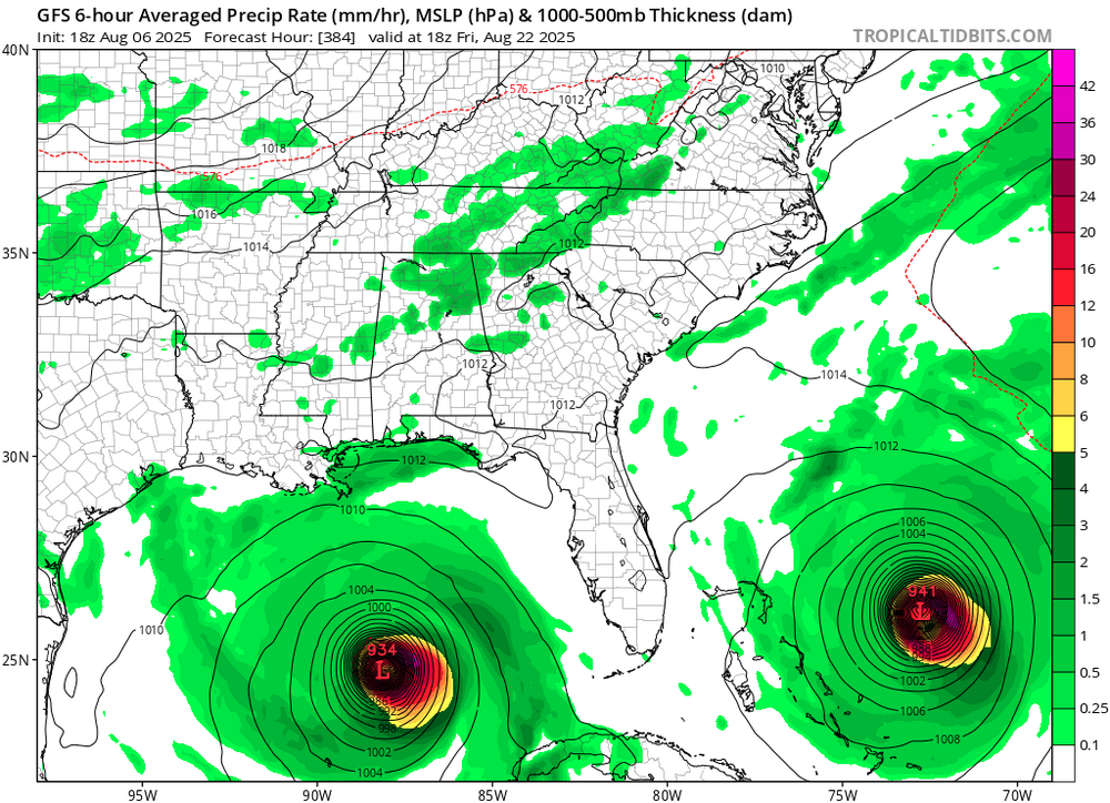
From yesterday. I know it's hr 384 but it got my brain going. Is there any historical precedent for what's shown, two sub 950mb canes approaching the SE simultaneously?
-
We've had almost no rain here since the flooding a few weeks ago. The ground is very dry and I'm having to water the vegetable garden often. Next week looks rough with very little chance of rain during the big heat wave. The grass will be burning out. I know Walt was talking about a potential flash drought a couple days ago. I hope we're not heading towards a drought like what happened last year at the end of the summer and the fall.
-
All I needed to see was 2014....I just ignored the rest of the years lol.
-

2025-2026 ENSO
40/70 Benchmark replied to 40/70 Benchmark's topic in Weather Forecasting and Discussion
2021-2022 ended up okay for most, but more often than not you are right. -
2025-2026 ENSO
PhiEaglesfan712 replied to 40/70 Benchmark's topic in Weather Forecasting and Discussion
I hope we get a good blocking pattern in November/December. The pattern that's in place early in a -ENSO/-PDO winter usually sets the tone for that winter. If we don't get a good blocking pattern early, the winter is toast. -
Dry conditions expanded heading into the heatwave next week. https://droughtmonitor.unl.edu/CurrentMap/StateDroughtMonitor.aspx?Northeast Northeast Drought Summary Very warm weather with persistently below normal precipitation for the past few weeks has allowed short-term moisture deficits to develop in a number of locations. Conditions have been the most anomalous across northern New England and far Upstate New York, where several areas of abnormal dryness (D0) were introduced. D0 was also brought in to parts of the immediate southern New England coast. A small area in southeastern New Hampshire and adjacent Massachusetts saw D0 conditions eradicated after 1 to 2.5 inches of rain fell this past week, but robust precipitation was not common across areas of existing dryness. Short-term precipitation deficits were also emergent in parts of New Jersey and Pennsylvania, but no dryness designation seemed appropriate yet, although these areas will need to be monitored for deterioration in the next few weeks if precipitation doesn’t return to near normal.
-

2025-2026 ENSO
40/70 Benchmark replied to 40/70 Benchmark's topic in Weather Forecasting and Discussion
Wife is from Uganda and has family there....she is orchestrating the construction and managing it...I've just assisted by procuring the funding. -
I’m just thrilled to see the sky as the smoke appears to be gone-hallelujah!
-

2025 Atlantic Hurricane Season
BarryStantonGBP replied to BarryStantonGBP's topic in Tropical Headquarters
-
managing a property from oversees? hmmm
- Today
-

2025-2026 ENSO
40/70 Benchmark replied to 40/70 Benchmark's topic in Weather Forecasting and Discussion
Should be great....we are just finishing up an 8 unit housing complex to fuction as an Air b & b.


