All Activity
- Past hour
-

SE Area of Interest--0% two day, 30% five day odds
Kevin Reilly replied to WxWatcher007's topic in Tropical Headquarters
Sea Surface temps up the east coast are a bit concerning for a tropical system IF atmospheric conditions are right to maintain its energy well northward up the coast. Case in point I am in Kitty Hawk NC right now and ocean water temps have been running 82-85 on the regular since I have been here Saturday. -
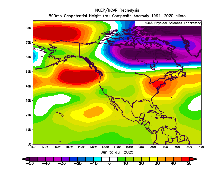
I am just commenting on what the model is showing. It’s striking how similar it is to the 500mb pattern we are getting this summer. If we do get a pattern resembling that next winter, then maybe the worst in terms of those severe -PNAs like we had in 21-22 and 22-23 is behind us. But it looks like the model still wants to go with the storm track through the Great Lakes which has been persistent since 18-19.
-

SE Area of Interest--0% two day, 30% five day odds
BarryStantonGBP replied to WxWatcher007's topic in Tropical Headquarters
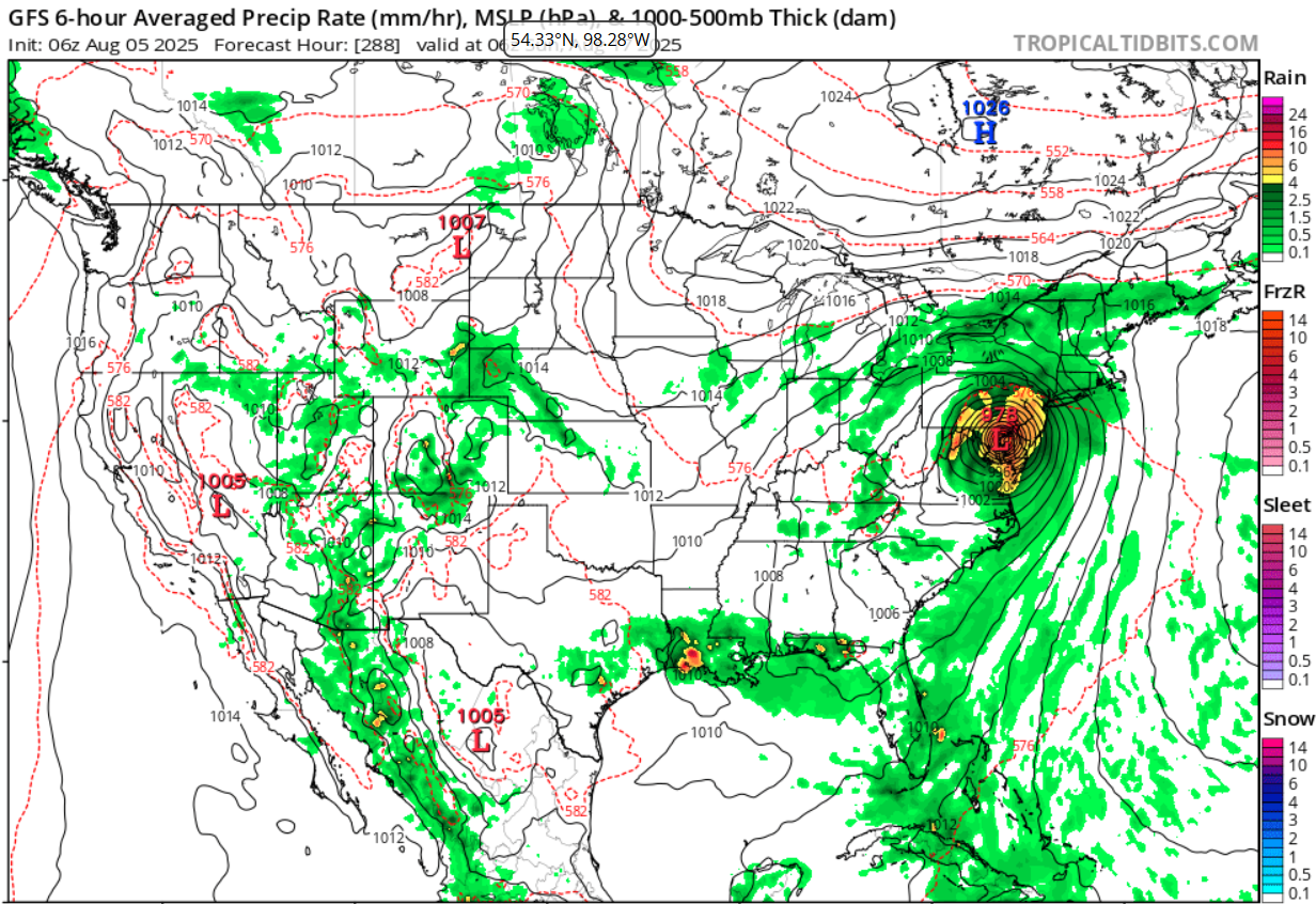
1. Off the Southeastern United States: A weak surface trough currently located several hundred miles off the coast of the southeastern United States is expected to form an area of low pressure in a day or so. Thereafter, environmental conditions appear favorable for gradual development of this system, and a tropical depression could form by the latter portion of this week or weekend as as the low initially moves slowly westward, but turns more northward by this weekend. * Formation chance through 48 hours...low...10 percent. * Formation chance through 7 days...medium...40 percent. -
Was at a concert last night and the moon was spectacular looking.
-
Yeah, it may have occurred in the past, but no where near the quantity of days in a row or for the summer like the last 5 years.
-
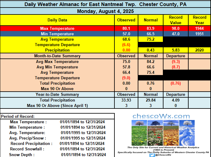
Following our first 4 days with well below normal temperatures we rebound today to near normal. It will be a bit cloudier both today and tomorrow. Clearer skies return on Thursday through the weekend with temperatures near to a little below normal levels for early August. Next rain chances look like next Monday at the earliest.

-

E PA/NJ/DE Summer 2025 Obs/Discussion
ChescoWx replied to Hurricane Agnes's topic in Philadelphia Region
Following our first 4 days with well below normal temperatures we rebound today to near normal. It will be a bit cloudier both today and tomorrow. Clearer skies return on Thursday through the weekend with temperatures near to a little below normal levels for early August. Next rain chances look like next Monday at the earliest.
-
While I can definitely see periods of -EPO, I doubt we see the same persistence we saw last winter from the end of November through the beginning of March
-
October?! Did you not see this Maryland Mauler 11 days out? Only concern is that with track like that and 540 line north of Goose Bay, ON we'll likely need rates to overcome column and sun angle issues, but were in the game! Waiting to hear MU's take before I get my hopes up too much.

-
The Euro has an active storm track through the Great Lakes for the crew in the favored lake effect snow zones.
-
Glad I don't live there.
-
 I'll assume the two experienced QBs get the start and try to have a winning season. If they fail, then we may see Dart, eventually, this season...
 -
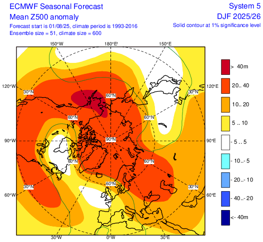
Looking at the 5H map I posted, from my perspective, I see "relative" weakness around and off Japan along with stronger ridging in Alaska. Both are positive if you're hoping for at least periods of opportunities during the winter.
-

2025-2026 ENSO
Stormchaserchuck1 replied to 40/70 Benchmark's topic in Weather Forecasting and Discussion
I don't think we will get a SE ridge if the Pacific H5 looks like that for the Winter. Their Pac ridge might be far enough south though.. I think it's persistence as last Feb looked like that with the dominant +h5 over 90N. Crazy how much it looks like June-July. -

2025-2026 ENSO
PhiEaglesfan712 replied to 40/70 Benchmark's topic in Weather Forecasting and Discussion
I'm hoping for a good early season blocking. At least the trickle down effects of that block will happen in January and February, a time when it can snow. A good late season blocking isn't going to save us. (2023 is a good example. Not a great early season block, but a very good late season one. By the time the cold pattern was in place from that block, it was May and June. The cold was impressive, as we didn't get that type of cold during that time of the year in nearly 40 years, but it isn't going to snow in June.) -
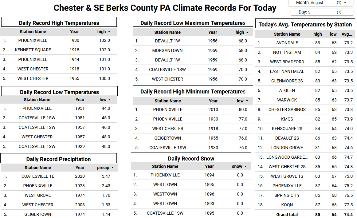
 Records: Highs: EWR: 102 (1944) NYC: 101 (1944) LGA: 100 (1955) JFK: 96 (2010) Lows: EWR: 57 (1951) NYC: 56 (1951) LGA: 57 (1972) JFK: 60 (1959) Historical: 1843 - A spectacular cloudburst near Philadelphia turned the small creeks and streams entering the Delaware River into raging torrents. As much as sixteen inches of rain fell in just three hours. Flooding destroyed thirty-two county bridges, and caused nineteen deaths. It is believed that several small tornadoes accompanied the torrential rains, one of which upset and sank more than thirty barges on the Schuylkill River. (David Ludlum) 1875: Several tornadoes moved across northern and central Illinois. One of the stronger tornadoes touched down in Warren and Knox County where it destroyed 25 homes and killed two people. Another in a series of tornadoes touched down near Knoxville and moved east into northern Peoria County. This estimated F4 tornado injured 40 people and was described by eyewitnesses as looking like a "monstrous haystack." 1904: Detroit Lakes woman is hit by lightning. It melted her hairpins and steel in corset but does not kill her.(Ref. AccWeather Weather History) 1915: Fort Wayne, IN set their coldest August high temperature with 60°. (Ref. Wilson Wx. History) 1961 - The temperature at Ice Harbor Dam, WA, soared to 118 degrees to equal the state record established at Wahluke on the 24th of July in 1928. The afternoon high of 111 degrees at Havre, MT, was an all-time record for that location. (The Weather Channel) 1961: McAllen, Texas: McAllen sets a new record high on Wednesday when the temperature soars to 105 °F. McAllen has now set a new record high on all but one day so far this month. (Ref. WxDoctor) 1974: Fort Walton Beach, Fla.--Lightning struck an aluminum ladder at a construction project. The man on the ladder was killed, three nearby workmen were injured. (Ref. Lightning-The Underrated Killer.pdf) 1980: Hurricane Allen was one of the most intense hurricanes ever observed in the Atlantic. On this date, the hurricane reached Category 5 status for the first of three times during its long path across the Atlantic as reconnaissance aircraft measured a 911 millibars (26.90 inches of mercury) pressure in the eastern Caribbean while south of Puerto Rico. Later this day, Allen moved across Haiti, ruining much of the country's coffee crop and killing 220 people.Casper, WY established new record low of 39°; breaking the previous record by 9 degrees. (Ref. AccWeather Weather History) 1983: Very heavy thunderstorms hit the southern portion of metro Denver, CO. 2.89 inches of rain fell in just 38 minutes causing widespread street flooding in southeast Denver. Two feet of water covered a section of Interstate 25. Hail up to golf ball size accompanied the storm in Littleton and Englewood along with 60 mph winds. (Ref. AccWeather Weather History) 1987 - Severe thunderstorms raked eastern South Dakota. The thunderstorms spawned half a dozen tornadoes, produced softball size hail at Bowdle, and produced wind gusts to 90 mph south of Watertown. Hot weather continued in eastern Texas. Afternoon highs of 100 degrees at Houston and 106 degrees at Waco equalled records for the date. (The National Weather Summary) (Storm Data) 1988 - Thunderstorms produced severe weather from Indiana and Lower Michigan to Pennsylvania and New York State during the day. Thunderstorms in Michigan produced wind gusts to 80 mph at Ashley, Hastings and Lennon. (The National Weather Summary) (Storm Data) 1989 - Thunderstorms produced severe weather in Oklahoma, and from Iowa to the Upper Ohio Valley, with 216 reports of large hail or damaging winds between early Saturday morning and early Sunday morning. Thunderstorms moving across Iowa around sunrise produced extremely high winds which caused ten million dollars damage to crops in Carroll and Greene Counties. Thunderstorm winds at Jefferson IA reached 102 mph. Afternoon thunderstorms produced tennis ball size hail at Bay Mills, WI. (Storm Data) (The National Weather Summary) 1995: Near Deerfield, KS, hail piled in huge drifts and stripped corn in a two mile wide swath. Hail drifts were still evident 24 hours later. Rain of over six inches in a short time caused flash flooding in the Deerfield area. Highway 50 was covered by three feet of water and was closed for several hours and limited to one way traffic for 24 hours. Sand was deposited on many streets bringing out heavy equipment to clear the debris. (Ref. Wilson Wx. History) 1999: Governors of four Mid-Atlantic States imposed mandatory water restrictions as the worst drought in the history of the region continued. The period April through July ranked as the second driest ever for the Northeast, second only to 1965. (Ref. Wilson Wx. History) 2000: A wet microburst with winds estimated at 120 mph caused heavy damage in and around Mitchell, SD. Apartments and several mobile homes were destroyed, vehicles were overturned, and other damage occurred to buildings and vehicles. Widespread tree and power line damage also occurred. 10 people were injured, although the majority of the injuries were minor. The damage path was approximately a mile and a half long and a mile wide, extending over the southwest part of Mitchell. (Ref. Wilson Wx. History) 2002: Tropical Storm Bertha became the first tropical system of the 2002 Atlantic hurricane to make a U.S. landfall. Bertha dumped 7.15 inches of rain on Pascagoula, MS in 24 hours. (Ref. Wilson Wx. History) 2020: Tropical Storm Isaias hit the eastern third of Virginia hardest on Tuesday morning during its brief but destructive journey up the Eastern Seaboard. Several hours of torrential rain flooded dozens of roads, while winds gusting past 45 mph downed trees and put hundreds of thousands of homes and businesses in the dark. The storm left scattered road closures and power outages in metro Richmond and more widespread disruption across the Tidewater region, where winds approached 70 mph. No serious damage was reported in the western half of the state. (Ref. The Richmond Times Dispatch)
 -
Only .73 here.
-
Yeah, very similar. It goes to the comments I made earlier. There is a disconnect between the higher latitude teleconnections and the mid-latitude pattern. So we still get the subtropical ridge from the Pacific across the U.S. and Atlantic even with the -EPO +PNA.
-
I wouldn't say it’s the same...more like similar.
-
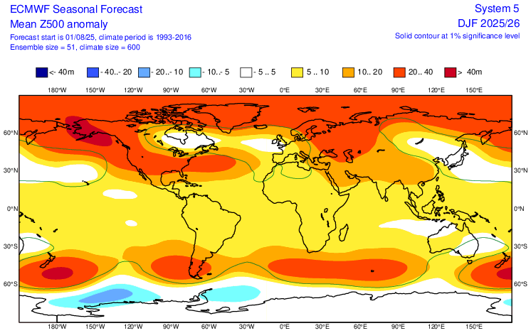
The Euro has the same winter pattern at 500mb as we are getting this summer. It’s a -EPO +PNA and Southeast Ridge pattern. Pattern persistence or the model is in repeater mode? Stay tuned….
-
5H Dec-Feb Euro
-
Even though the air quality alert was taken off the forecast here in Delaware I can smell forrest fire smoke.
-
Already said it, but I agree with you on -PNA this winter….2nd year -ENSO….very strong tendency. As far as the NAO being “super” positive, I doubt it, but I could definitely see a predominant +NAO this winter, especially if this SST alignment continues through fall, other factors (solar, geomag, lack of a tripole in June) we already talked about argue for that too
-
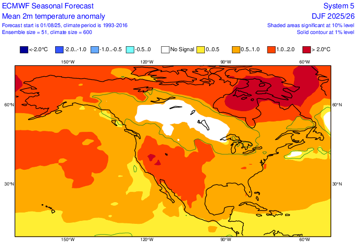
And DEC-FEB is +.5-1C. Very workable with normal precip it is also predicting. Monthly forecast indicates January very close to normal with February, like most Niñas, the most AN.
-
71 / 67 - cloudy. Clouds will limit any shot at 90 still warm / humid mid - upper 80s, enough sun could get the hotter spots to 90. Cooler Wed, cloudy and isolated showers in the PM/ overnight. Clear out Thu and a great stretch Thu - Sunday - mainly clear, dry and near to slightly below normal. Flow comes around later on the 8/10-11 with a warm - hot / humid and wetter overall. Heat more widespread Tue - Thu next week. Flow still a bit onshore-ish. Tropics activity but overall ridging into the EC, - warm - hot at times , more humid and wetter with frontal boundaries and tropical systems to be watched. 8/5 - 8/10 : Overall near normal - dry 8/11 - Beyond : Warm- Hot - Humid - wetter overall - Tropical activity - heat 8/11 - 8/14 -tropics focus 8/15 onward. (Ctrl + Refresh) to update live satellite loop