All Activity
- Past hour
-

December 2025 regional war/obs/disco thread
40/70 Benchmark replied to Torch Tiger's topic in New England
If I get a March 2018 block to follow, then sign me up- -
Pretty meager.
-
He does amazing work.
-

December 2025 regional war/obs/disco thread
Typhoon Tip replied to Torch Tiger's topic in New England
You've hinted pretty well at the two primary reasons I've suspect since September this may be an early loaded winter, followed by some struggles. I thought at the time an early spring, too. I sort of sarcastically mused, 'flower February' ... Just expand a little on the climate aspect ( CC not included). This type of low amplitude La Nina autumn/winter in the past preceded some spectacularly warm springs. Gotta dust off the antiquity, but 1976 and 2012 ...etc.. They're there, if one goes and just cursory runs their finger down the ENSO history, they'll see the negative ENSO years, and then compare those to notably warm springs there's a pretty clear correlation there - no, not 1::1 ...work with me here. It's there, and it's non-noise. So, now add 20 years of accelerating CC. Which unfortunately for those that have issues with this reality ... springs have begun expressing bigger heat relative to climate, and also all-time, with increasing frequency. I mean, there have been heat-related deaths in lower China in Marches. It's a matter of time before a February 2017 type ridge returns, here, and perhaps and does so with greater duration. I just see as an idea here, that if we combine this latter aspect with the aforementioned climate inference farther above, we don't get a protracted winter sense of it. Also, the near history ( last decade's worth) of winters have become all but dependably similarly behaving - in principle. Despite whatever background/preceding ENSO this or that was observed, leitmotif: some early form of early blocking and snow supporting synoptics ( sometimes as early as Octobers for the first time in my life), then, the circulation gets blown open by midriff seasonal velocity saturation. I'm sorry, since September, see and sense that lurking again ... One thing recent La Nina have not performed very well, is that early climate signaled warmth, however. It may be Russian Roulette with that if/when water finds its level. -
December 2025 regional war/obs/disco thread
40/70 Benchmark replied to Torch Tiger's topic in New England
So 2020s is a new low so far... -
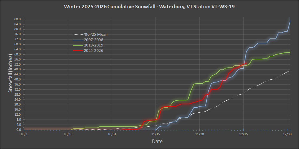
Now that we’ve hit the mid-month period, I’d ben meaning to put out an update on the seasonal snowfall progression and check where things stand with respect to other seasons. As the data show, this season’s snowfall progression (red trace in the plot below) is clearly running above average. But as much as everyone has been talking about how outstanding this season has been, its snowfall is really just running in a similar manner to how 2018-2019 progressed (green trace in the plot below). In fact, this season has generally been running behind the 2018-2019 snowfall pace. And for even more perspective on this season’s snowfall, it’s now well behind the 2007-2008 pace (blue trace in the plot below). At this point, the second half of December would have to put on quite a snowfall performance to even be in the same league as 2007-2008. That was a season which essentially stacked a 20-inch November with a 70-inch December, so it’s not surprising that it holds the current snowfall record for that combo in my data set. As of mid-December, all of the resorts along the spine of the Northern Greens have recorded 100”+ of snowfall on the season, and Jay Peak is approaching 200”. But, this season’s snowfall is basically running in line with what we saw just had a few season’s back, and well behind 2007-2008, so why does it seem like such a strong start? The deviation from average snowfall pace may be a bit more in the mountains that the valleys, but I think a big factor in making this feel like such a strong start to the season has been the temperature consistency. Indeed temperatures have been well below average over this stretch, but they don’t have to deviate much if at all from, average to get good snow at this time of year – especially in the higher elevations. I’m sure there are seasons that can attest to that, but I really think it’s the temperature consistency that has been helping to get us to where we are. Temperature consistency has clearly been a positive, but somewhat inseparable from that factor in this great start to the ski season has been the general pattern/storm track. And one could argue that the process of getting all the snow we’ve seen has been a bit counterintuitive. The local resorts have reached 100”+ of snowfall in just a month or so without any huge coastal systems, and without even getting any of our classic stacked lows sitting in the Maritimes. All this snow has basically been achieved through modest bread and butter systems without a highly amplified pattern. What’s certainly impressive is that we’ve gotten to where we are with a generally progressive flow of Clippers and similar events, but the more important part is that without a highly amplified pattern, we haven’t had to deal with many warm storms passing to our west. We’ve seen few rainy systems, and even few mixed precipitation events over the past month or so. If you ask me, that’s why Mansfield has achieved this record snowpack – it’s avoiding the “two steps forward… one step back” type of sequence that comes with those more amplified patterns and huge systems. I don’t think it would be strange at all for someone to assume that if you’re going to get to a record Mansfield snowpack, you’d need to do it with the help of a monster system or two… but this season flies right in the face of that idea. Cleary, the type of pattern we’ve been seeing is something notable/special if it’s tied or beaten out snowpack depths from the past 70 to 80 years of record keeping. We obviously know about the critical importance of these types of patters up here with the fact that we use the “bread and butter” terminology, but I’ve come to appreciate them more and more every year. Growing up, we were always on the lookout for “nor’easters”, since they obviously make a big splash in the news, and everyone talks about them, but as kids we wouldn’t have known any better. If this type of less amplified/more progressive weather pattern that we’ve been seeing is indeed going to become more common around here as some of the meteorologists are suggesting, one has to think there’s going to be improving chances for more stretches like this. It’s definitely going to be interesting to see (and ski) if we get more of these stretches going forward.

-
Interesting Christmas solution on GFS today. certainly different and further south track of what appears to be a warm core clipper....I totally made that up...no such thing...
-

Winter 2025-26 Medium/Long Range Discussion
Malacka11 replied to michsnowfreak's topic in Lakes/Ohio Valley
Someone w some cash to burn should acquire one of those fake snow systems that ski resorts use and see what happens. Maybe we can reverse-psychology ma nature into putting up finally... or you can pay my block a visit, it works out either way. -

December 2025 regional war/obs/disco thread
WxWatcher007 replied to Torch Tiger's topic in New England
Still a little Christmas Eve snow on the GFS -
We can ask the same question for Christmas, apparently.
-
we got all sorts of wind and fire out here! (probably not that much fire)
-

Central PA Winter 25/26 Discussion and Obs
TimB replied to MAG5035's topic in Upstate New York/Pennsylvania
And then what happens later in Christmas week? Any shot at a white Christmas in Chester County? -
December 2025 regional war/obs/disco thread
40/70 Benchmark replied to Torch Tiger's topic in New England
Okay, that is what threw me off...I saw hot it compared to the 90s, which I perceive as a good decade. -

December 2025 regional war/obs/disco thread
Patrick-02540 replied to Torch Tiger's topic in New England
Yes, I stand corrected. There was missing info in my data set post-depression from 1929 through 1935. -
No they didn’t that well. That’s like 8-10” below climo. Where they got skunked a bit was the 1990s compared to ORH and BOS.
-

December 2025 regional war/obs/disco thread
Kitz Craver replied to Torch Tiger's topic in New England
It doesn’t last too long but it’s pretty intense discomfort -
It is also one of the coolest stations during summer heatwaves due to the overgrown tree canopy, so this cuts both ways.
-
I’m not seeing a way out (yet) from a canonical Niña February, I’ll reserve my final opinion once we are into January. That said, if there is in fact a major SSWE in February like you think there will be, with the lag, I would think that would/could affect March more so than February, especially if it occurs closer to mid-February (i.e. 2018)
-
Hartford averaged 37” in the 1930s
-
Up to 32.7° No real signs of dripping yet.
-
December 2025 regional war/obs/disco thread
40/70 Benchmark replied to Torch Tiger's topic in New England
That was one my one great event...I had 16", but my mom in Wilmington had like 20". -
That early Feb storm was a screw job for a lot of people, myself included when I was in RI.
-
December 2025 regional war/obs/disco thread
40/70 Benchmark replied to Torch Tiger's topic in New England
My 4 yr old and now 11 month old have it. -
December 2025 regional war/obs/disco thread
Typhoon Tip replied to Torch Tiger's topic in New England
Looping vis suggests this is transient and you open up out there over the next hour. We'll see. May not be "sunny" today, but a compromise -
December 2025 regional war/obs/disco thread
Patrick-02540 replied to Torch Tiger's topic in New England
I only remember the 80s for 3" of snow followed by sleet an slop. Maybe it happened often, though.


