All Activity
- Past hour
-
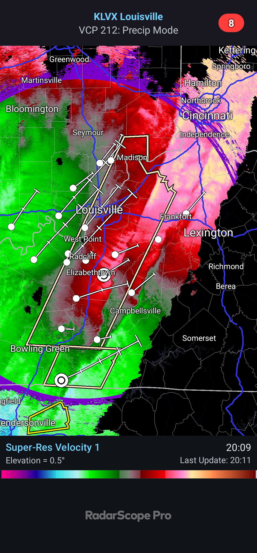
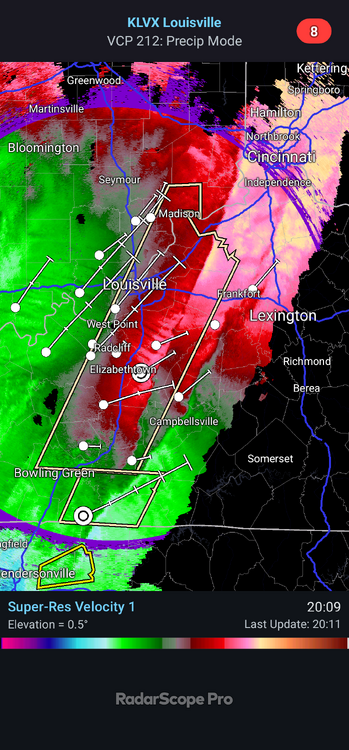
Crazy line showing up on velocity!
-
Xmas 2020 was pretty epic. We lost power Xmas morning.
-

December 2025 regional war/obs/disco thread
WinterWolf replied to Torch Tiger's topic in New England
Yes. -
Light rain and drizzle during past 5 hours or so, temp locked between 39-40. Currently 39.4/38.8.
-
-
Always take the under. The best winds are always from some unhyped front coming through.
-
Dam that line is fierce. 2 squall lines just merged into 1 down in Tennessee.
-
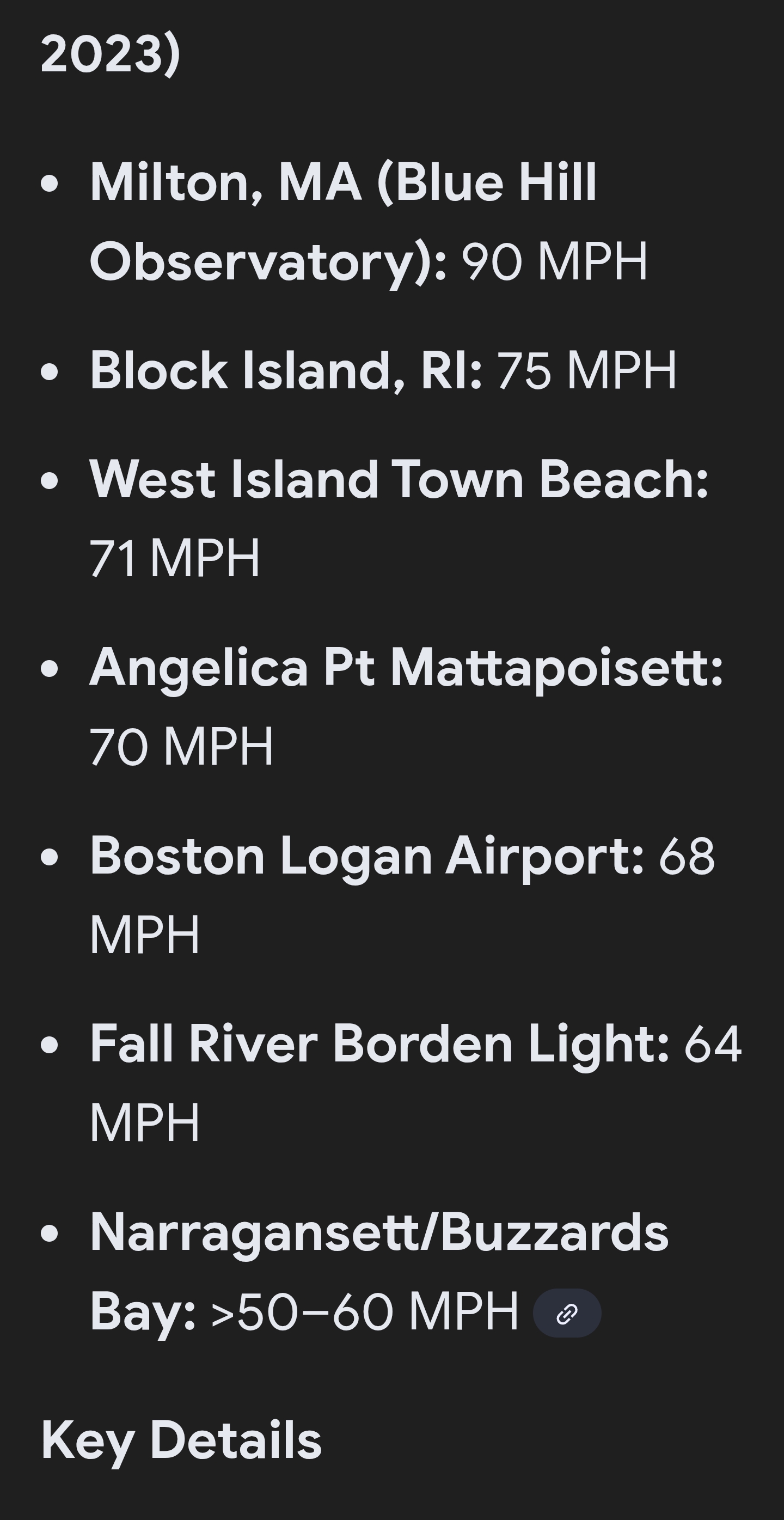
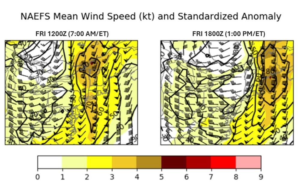
in case folks missed the BTV area discussion earlier: https://forecast.weather.gov/product.php?site=BTV&issuedby=BTV&product=AFD&format=CI&version=1&glossary=1 Sfc analysis places powerful and deepening 985mb low pres near Ely MN, while a 1030mb high pres is acrs the north Atlantic. Upper air analysis shows sharpening full latitude mid/upper lvl trof acrs the central Plains, while deep moisture advection continues on a strengthening south to southwest flow in the 925mb to 500mb layer. As sfc low pres deepens the 925mb to 850mb wind fields strengthens overnight into Friday acrs our region. The NAM and RAP both show progged 850mb winds of 75 to 90 knots, while 925mb winds are in the 55 to 70 knot range, highest over the northern Dacks into the northern CPV. The difficult challenge continues to be how much mixing occurs, as the strongest winds are co-located with the axis of heaviest rainfall. However, given the progged fine line of convective showers by NAM3KM/HRRR, the embedded heavier down pours would have the potential to tap very strong winds in the 925mb to 850mb layer and transfer some higher speeds to the sfc. Given this potential and latest RAP/HRRR soundings showing 500 foot agl winds of 45 to 55 knots, with 59 knots at Malone at 12z Friday, we have expanded the wind advisory. HREF shows 60 to 80% prob of 60 mph or greater winds along the Route 11 corridor and acrs parts of central/northern VT with <30% prob of winds greater than 65 mph, while indicating 90 to 100% of winds >45 mph acrs most of our cwa. Did consider High Wind Warning for northern Dacks, but southeast direction and still some uncertainty on boundary layer mixing, may limit areal coverage of 60 mph wind gusts. Still something to watch closely. Also, have some concerns over southern Greens with southeast downslope gusts near Rutland, but soundings are showing slightly weaker low level wind fields and limited mixing due to the moist adiabatic sounding profile and weak inversion above ridgetop. Generally thinking wind gusts in the 45 to 55 mph range, which wl peak between 4 AM and Noon on Friday.
-
The sun is now burning the other side of the Earth! So terrible for them.
-
Sorry but try again. A trace isn't considered measurable by the NWS. You started by saying 9 in a row multiple times, then 7 now your down to 5
-
December 2025 regional war/obs/disco thread
WinterWolf replied to Torch Tiger's topic in New England
Lol..none of those dates ring a bell…meh here WOR….as always, unless Tropical. -

December 2025 Short/Medium Range Forecast Thread
Holston_River_Rambler replied to John1122's topic in Tennessee Valley
Sorry about that: https://mesonet.agron.iastate.edu/current/mcview.phtml?prod=usrad&java=script&mode=archive&frames=400&interval=60&year=1995&month=12&day=25&hour=0&minute=0 -
48 at both my stations for the high today.
-

December 2025 regional war/obs/disco thread
Ginx snewx replied to Torch Tiger's topic in New England
Don't know what but we are in for a blast. 12/18/23 Pete rePete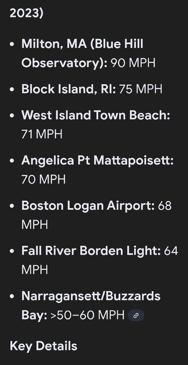
-
.
-
.thumb.png.4150b06c63a21f61052e47a612bf1818.png)
December 2025 regional war/obs/disco thread
HIPPYVALLEY replied to Torch Tiger's topic in New England
We’ll see, but I’ll take the under. Which is easy to do in the valley anyway. I hope Kevin can rip some 50-60 mph. -

December 2025 Short/Medium Range Forecast Thread
Golf757075 replied to John1122's topic in Tennessee Valley
I watched dan satterfield, who was the chief met out of huntsville al on YouTube clips for that winter storm. It was wild. I lived in Hernando ms at the time and we barely got it where I was. -
Comes down to rain and mixing. If it rains it lowers temps and limits mixing. Ideally you want a break between 11-3p, but they’ll be times of downpours.
-
-
Surprisingly, Euro weeklies are not quite as warm as yesterday fwiw. It keeps us near or just south of the normal line unlike yesterday which had us AN until the end of January. But it's not a pattern conducive to snowfall. Looks more like our chances would be along the lines of threats advertised on the 6z Gfs, if anything. Here's a link. You can adjust the date of the runs to see what the previous 3+ weeks of runs looked like too. https://charts.ecmwf.int/products/extended-anomaly-2t?base_time=202512180000&projection=opencharts_north_america&valid_time=202512290000 Edit: all weekly products can be found here: https://charts.ecmwf.int/?facets={"Product type"%3A["Experimental%3A AIFS"]%2C"Parameters"%3A[]%2C"Type"%3A[]%2C"Range"%3A["Sub-seasonal"]}
-
December 2025 regional war/obs/disco thread
HIPPYVALLEY replied to Torch Tiger's topic in New England
Steal it all! Take their potential snowy joy and shatter it like a delicate tea cup, on a frigid, dry, January night. bwah, ha ha ha -
No one knows.
-
December 2025 regional war/obs/disco thread
HIPPYVALLEY replied to Torch Tiger's topic in New England
Cut everything by 50% and it’s will be closer to reality. -
Hello from NE FL. ! 70 and a light breeze as I sit on the porch and watch the surf. First of a few trips planned over the next couple of months. I lived here for 13 years so can pretty much leave it lol. Enjoy the torch!
-

December 2025 Short/Medium Range Forecast Thread
Matthew70 replied to John1122's topic in Tennessee Valley
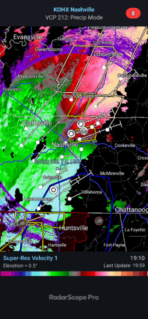
Well gotta say. This line of rain & storms is slow moving & dumping.