All Activity
- Past hour
-
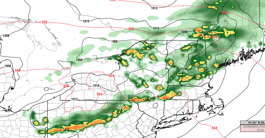
Models have been hinting at this potential for the past 7-8 days with very little wavering...pretty impressive to see. I wouldn't be surprised if that got extended a bit east as well. One downside though is the overall forcing doesn't appear particularly strong. What this is going to do is likely negate this from producing scattered thunderstorm activity within the region as a whole. The best likelihood is probably going to be across like VT/NH/northern MA where there may be some better forcing and also on the edge of the stronger llvl airmass/theta-e gradient. Probably see at least one cluster roll through here. Maybe differential heating can pop some stuff elsewhere
-
This week is going to be brutal for sure. It is painful to see so many 90's F in the forecast this early ugh.
-
Saw a lot of commentary online criticizing them for it too. People have no clue how hard it is to get any grass looking healthy in a drought with Georgia heat, let alone bentgrass greens. I agree, irrigation helps to a degree but it can’t replace the type of soaking that rain delivers.
-
...can use this too.National 7-Day Significant Fire Potential
-
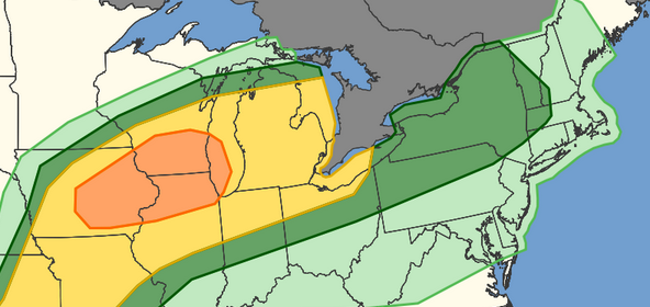
...Northeast... Rounds of thunderstorms are expected during the afternoon and evening within a warm advection regime. MLCAPE should increase to around 1000 J/kg within a moistening low-level airmass. Strong deep-layer westerly flow and steepening low-level lapse rates will support isolated strong wind gusts across the region. I wouldn't be shocked if the Marginal gets extended E and a smaller Slight region gets embedded..
-

Central PA Spring 2026 Discussion/Obs Thread
Mount Joy Snowman replied to Voyager's topic in Upstate New York/Pennsylvania
Low of 51. Had our first fire pit of the season last night. Now comes the heat. -
True but I've seen some longer range winter predictions using analogs from even further back (1950's and 60's) Just not as reliable anymore but fair to say 1995 is recent enough that it's not as bad of a match. we will see. But always rooting against a 2009 type summer that was just awful.
-
We just keep heading headlong into this crap. Totally OT for wx stuff, but... Feelin' like it's all over Feelin' like there's no love Feelin' like it's not easy Breathin' life in the dust On a countdown to zero Take a ride on the nightmare machine There ain't gonna be heroes There ain't gonna be anything, oh Here it comes, here comes the night Here it comes, hell in the night Here it comes, here comes the night When we all fall down When we walk into silence When we shadow the sun When we surrender to violence When the damage is done Put away that gun I don't wanna be there I don't wanna be anywhere, oh Here it comes, here comes the night Here it comes, hell in the night Here it comes, here comes the night That's right We're fightin' for the gods of war But what the hell we fightin' for? We're fightin' with the gods of war But I'm a rebel And I ain't gonna fight no more, no way On a countdown to zero Take a ride on the nightmare machine There ain't gonna be heroes, whoa There ain't gonna be anything, no Here it comes, here comes the night Here it comes, hell in the night Here it comes, here comes the night Don't ya know that's right? We're fightin' for the gods of war But what the hell we fightin' for? We're fightin' with the gods of war And I ain't gonna fight no more Stop (stop fightin' for the gods of war) stop fightin' for the gods of war (Yeah, what the hell we fightin' for?) What the hell we fightin' for? (We're fightin' with the gods of war) Heavy! "Message to terrorists everywhere, You can run, but you can't hide" "We're determined to stand together and we're determined to take action" "We're not going to tolerate these attacks from outlaw states" "We will not cave in" "Today, we have done what we had to do" "He counted on America to be passive. He counted wrong"
-
Add 1.5 degrees then to 1995. Wouldn't change what he said. We aren't talking about 1820.
-
We will see... either way I hope this Summer goes by quick.. Summer sucks once we go above 85 unless dews are low
-
Big difference in lapse rates on NAM versus GFS tomorrow. NAM keeps feeding in steeper lapse rates throughout the day while the GFS weakens them a bit before another surge of steeper lapse rates build in.
-
Exactly. Some of these analogs are not as useful given how much we have warmed since the 90's
-
Hi res has some big boomers out that way too. And I don’t just mean retirees from NYC.
-
It’s also windy AF out. But finally some dim sun.
-
Too bad we don't have better lapse rates Tuesday afternoon because that looks modestly interesting given the other synoptic parameters. W to WNW at 700 mb, SW below 850mb is a directional +helicity. About 20 to 25 kts +d(v) between 925 and 500 so not great speed shear. But I said "modestly" heh But a front is approaching into a DP anomaly that pushed its way up to S VT/NH latitudes in most guidance. > 60 F, with ongoing temperatures 80+. This is a June CAPEd air mass smeared up under an impulse cutting through N VT/NH late in the afternoon and evening, arriving after the morning and early afternoon were baked under more sun than clouds. As an aside, tomorrow is going to seem out of place. Anachronistic because the landscape is still lagged lagged so far behind what people typically associate with air of summer aroma. Anyway, the Euro still sniffing out enough instability and a mechanics to ignite broken lines of coherent convective QPF structures in these charts.
-
Wow, the gradient of natural snow has been so pronounced all season in VT. I skied Killington Wednesday and Thursday and the natural snowpack was pretty sparse. Skied Friday at SLoaf and natural terrain on upper half of mountain was still very good, i.e. bubblecuffer and king pine area.
-
General rule is that pre-strong nino summers are colder and post-strong nino summers are warmer in the East. It wasn't 1995 (that was one of the warmest summers on record, as was 1993 and 1994). However, both 1996 and 1997 were cooler summers (1997 was a pre-nino summer). It must have been one of those years. The only time the rule didn't hold was when the pre-nino summer of 1991 was very warm, and the post-nino summer of 1992 was cool. However, we had a major volcano in 1991 (in Pinatubo), and that screwed things up. 91-92 behaved more like the reverse of the way a strong el nino would normally. Global temperatures actually cooled, as the effects of Pinatubo canceled out a robust el nino. Pre-strong nino/post-strong nino summer average temps (PHL) since 1970 72-73: pre-nino summer 72 (73.9); post-nino summer 73 (77.1) 82-83: pre-nino summer 82 (73.0); post-nino summer 83 (75.7) 86-88: pre-nino summer 86 (75.3); post-nino summer 88 (77.1) [summer 87 during the el nino was 76.5] 91-92: pre-nino summer 91 (77.9); post-nino summer 92 (74.0) 97-98: pre-nino summer 97 (74.2); post-nino summer 98 (75.7) 09-10: pre-nino summer 09 (75.1); post-nino summer 10 (79.6) 15-16: pre-nino summer 15 (77.7); post-nino summer 16 (78.8) 23-24: pre-nino summer 23 (75.8; although JAS was 76.1); post-nino summer 24 (78.5)
-
FYP.
-
The summer of 2023 wasn’t really that cool at all. But relative to the other recent years it seemed that way. I guess the new definition of a cool summer in the 2020s is under 30 days reaching 90° at a warm spot like Newark as was the case in 2023. An actual cool summer like 2014 and 2009 had 15 or fewer days. A really cool summer like 1996 had under 10 days. Time Series Summary for NEWARK LIBERTY INTL AP, NJ - Jan through Dec Days Reaching 90° Click column heading to sort ascending, click again to sort descending. 2025 39 0 2024 33 0 2023 29 0 2022 49 0 2021 41 0 2020 31 0 Coolest summers since 1961 Time Series Summary for NEWARK LIBERTY INTL AP, NJ - Jan through Dec Days Reaching 90° Click column heading to sort ascending, click again to sort descending. 1 1967 7 0 2 1996 9 0 3 1985 11 0 4 1982 12 0 - 1975 12 0 5 2004 13 0 6 2009 14 0 - 1962 14 0 7 2014 15 0 - 1976 15 0 - 1969 15 0 The thing to watch as we head into the summer is if a much wetter pattern than we have been experiencing can develop. Since we had some record rainfall and flooding events going into the summer in 2023. Hard to tell at this early stage if this El Niño will respond with that much wetness. Long range precipitation forecasting is very low skill.
-
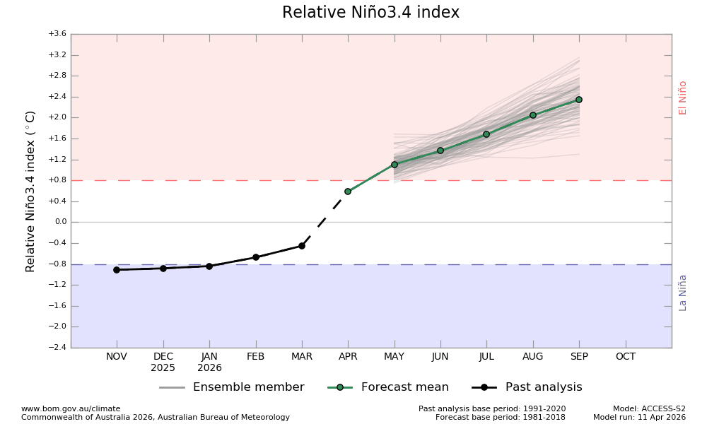
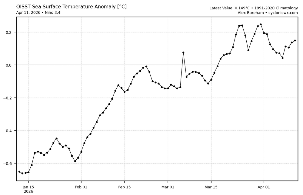
The newest BoM prog (dated April 11th) is unchanged and thus still has a RONI of +0.6 for April averaged out. This is almost certainly going to end up much too warm for April: How do I know it is almost definitely going to bust much too warm for April? Weekly RONI equivalent: 3rd column is 3.4 01APR2026 0.6 -0.3 -0.2 0.3 08APR2026 1.0 -0.2 -0.3 0.2 https://www.cpc.ncep.noaa.gov/data/indices/rel_wksst9120.txt So, the weeks centered on April 1/April 8 were -0.2/-0.3. Here’s the current OISST, which isn’t relative and thus one needs to subtract ~0.5 from it: As the above chart shows, there’s been no net warming for the last 3 weeks and the latest few days of OISST have been only +0.05 to +0.15. Subtracting 0.5 gives ~-0.4 for the RONI equivalent. April 1-11 OISST are likely no warmer than ~-0.3 for RONI equiv. To be conservative in converting from OISST to ERSST, I’ll call it -0.2 for RONI MTD. The weeklies I showed suggest between -0.2 and -0.3. How is it even possible for April RONI as a whole to come in anywhere near as warm as +0.6? These daily OISST readings (don’t forget these are not relative) would need to skyrocket to an avg of at least ~+1.5 for Apr 12-30!! And with OISST starting off at <+0.2, there are going to have to be some +2++ dailies starting no later than 2 weeks from now! Nothing even remotely close to that extremely rapid rate of warming has occurred on record. Thus, BoM is looking to bust much too warm for Apr RONI. With Apr being way off, the credibility of the rest of the run is compromised.
-
Nino summer are not exactly known for warmth. I dont know if thats in play this summer or next, but I remember one such summer in 1995 when the AC rarely if ever went on. Granted, it was a cooler climate back then
-
The other thing to consider is that the long range models showed blocking developing in late March-early April and it never happened. So let's see if this is real or more longer term forecasts that don't work out.
- 353 replies
-
- 1
-

-
- april showers bring may..
- rain
- (and 2 more)
-

Central PA Spring 2026 Discussion/Obs Thread
Jns2183 replied to Voyager's topic in Upstate New York/Pennsylvania
I just want to get it as cold as possible going into this monstrosity. Our Average high the past 25 years this week is 65 degrees which appears to be our low temperature this week Sent from my SM-S731U using Tapatalk
-
April 13 1949: A late-season snowstorm dumps over 9 inches in parts of the Twin Cities metro area. For Monday, April 13, 2026 1877 - The second coastal storm in just three days hit Virginia and the Carolinas. The first storm flattened the sand dunes at Hatteras, and widened the Oregon inlet three quarters of a mile. The second storm produced hurricane force winds along the coast of North Carolina causing more beach erosion and land transformation. (David Ludlum) 1955 - The town of Axis, AL, was deluged with 20.33 inches of rain in 24 hours establishing a state record. (The Weather Channel) 1986 - A major spring storm quickly intensified bringing blizzard conditions to much of the Northern Plains Region. Up to 18 inches of snow was reported in North Dakota, and in South Dakota, winds gusting to 90 mph whipped the snow into drifts fifteen feet high. Livestock losses were in the millions of dollars, and for some areas it was the worst blizzard ever. (Storm Data) 1987 - Thunderstorms in northern Texas produced wind gusts to 98 mph at the Killeen Airport causing a million dollars property damage. Two airplanes were totally destroyed by the high winds, and ten others were damaged. (The National Weather Summary) (Storm Data) 1988 - Low pressure off the Atlantic coast produced high winds across North Carolina, with gusts to 78 mph reported at Waves. The high winds combined with high tides to cause coastal flooding and erosion. About 275 feet of land was eroded from the northern tip of Pea Island. (The National Weather Summary) (Storm Data) 1989 - Thunderstorms in central Florida produced golf ball size hail and a tornado near Lakeland FL. Fair and mild weather prevailed across most of the rest of the nation. (Storm Data) (The National Weather Summary) 1990 - Thunderstorms developing along a cold front produced severe weather in central Oklahoma and north central Texas. Thunderstorms in Oklahoma produced up to six inches of golf ball size hail along I-40 near El Reno, and produced wind gusts to 75 mph at Okarche. Thunderstorms over north central Texas produced softball size hail northwest of Rotan, and high winds which injured two persons southeast of Itasca. (The National Weather Summary) (Storm Data) 2004 - The latest measurable snowfall on record hits Jackson, TN, causing six traffic fatalities. 2006 - The University of Iowa campus is hit by an F2 tornado. The storm severely damaged many buildings in the area, including a sorority and a local church. No fatalities were reported in the storm that caused more than $12 million in damage.
-
yup definitely going to need sun for sure, probably especially to our southwest because there doesn't seem to be much in the way of momentum to really blow this warm front through. Haven't looked at any guidance since Friday but I do recall on Friday thinking there was a chance we could be mucked in a bit longer on Monday. Could be a day where like Danbury, CT is able to just get into sun/warmer airmass and pull out a 73 while most everyone else is barely into the lower 60's. But idk...there might be an opportunity to start ridding of this lower cloud deck late morning