All Activity
- Past hour
-
GFS pretty insistent on patches of 80s dews late this coming weekend/early next week.
-

July 2025 Obs/Disco ... possible historic month for heat
weatherwiz replied to Typhoon Tip's topic in New England
Wow...that is incredible!!! The part where you have the warm/moist air along the FFD feeding into wall cloud and funnel was probably my favorite part. That was probably the best visual/simulation I've ever seen. Granted this was one of the most textbook tornadoes captured on record but still. This deserves to be included in any severe wx class (undergrad or graduate). -

July 2025 Discussion-OBS - seasonable summer variability
IrishRob17 replied to wdrag's topic in New York City Metro
Meh, that rounds to 60 and you know it LOL. 53 and 58 up here in the great north woods the past two mornings -
Actually a pleasant start to the day. A bit of breeze, good cloud cover, actually feels a bit stormy. Would love to see temps bust today
-

July 2025 Discussion-OBS - seasonable summer variability
psv88 replied to wdrag's topic in New York City Metro
59.9. We did it -

July 2025 Obs/Disco ... possible historic month for heat
dendrite replied to Typhoon Tip's topic in New England
GFS is trying to deliver a frost/freeze to the pits of NNE.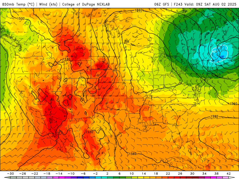
-

July 2025 Obs/Disco ... possible historic month for heat
MegaMike replied to Typhoon Tip's topic in New England
My advisor would always tell me that! Someone did manage to simulate a tornado (EF5 in El Reno 2011) using a modeling system intended for very fine atmospheric phenomena (CM1): https://www.mdpi.com/2073-4433/10/10/578 If you wanted, had the resources (19,600 nodes -> 672,200 cores & 270 TB worth of space), and had a lot of time, you can run the simulation too! In serial mode (single CPU), it'd take decades for this simulation to complete. Really, we have the modeling systems to run highly accurate simulations, but unfortunately, data assimilation and (relatively) limited resources is inhibiting us. A nice video of the results: -

July 2025 Obs/Disco ... possible historic month for heat
AstronomyEnjoyer replied to Typhoon Tip's topic in New England
46.0° this morning. House is delightfully cold. Hoping to make it to Saturday without turning on the AC, though it's not like a single 8000 BTU window unit can do much anyway. -
I don’t think it’s accurate to say there’s no climate crisis from GW. The combo of the melting of land based ice flowing into the oceans as well as expansion of ocean water has been causing an accelerating rise of sea level. Also, higher dewpoint air being able to hold more moisture as well as a slight reduction of avg steering flow due to a reduced temp. contrast between the rapidly warming Arctic and the significantly slower warming of the tropics have combined to cause a notable increase in flooding rainfall events. That being said, not everything about GW has been bad. One great thing is that global food supply has increased markedly due to larger crops. This is due to longer growing seasons (longer period between freezes) accompanied by increased moisture and the ability to grow crops further north. In addition, plants have more CO2 to take in for photosynthesis. I’ll reiterate that had we instead of GW had the same amount of cooling, global food supply would be much, much smaller thus likely leading to starvation of at least hundreds of millions. Another mini-ice age would have been terrible.
-
July 2025 Obs/Disco ... possible historic month for heat
weatherwiz replied to Typhoon Tip's topic in New England
Heavily debated throwing the heat on in the car for a bit this morning. Was chilly when I got in. -

July 2025 Obs/Disco ... possible historic month for heat
weathafella replied to Typhoon Tip's topic in New England
It seems like WAR may be a big feature once we move into the 2nd week of August. That may coincide with a much more active tropical Atlantic. -
Record warm daily minimum of 72F tied yesterday in St. Cloud, Minnesota (records since 1893). Saw several other sites that had their second or third warmest lows for July 23. Should see multiple records over the coming days across the central U.S.
-

July 2025 Obs/Disco ... possible historic month for heat
mreaves replied to Typhoon Tip's topic in New England
The low was 46° yesterday and 47° today. Beautiful sleeping weather. -
We will adapt as we always have whether we cool or warm.....the bottom line is there is of course no climate crisis!
-
Iommi said he looked like Gollum and he did.


-

July 2025 Discussion-OBS - seasonable summer variability
doncat replied to wdrag's topic in New York City Metro
My station currently running a 79.3° mean for the month....warmest month ever recorded in 47 years is 80.5° set back in 1999. -
It wasn’t Irene because that one didn’t occur til mid Oct. Sept. 27-30 definitely wasn’t from a TC per the NHC archives for 1999. There also was no TD then. However, with heavy rainfall like that, there likely was ample tropical moisture in the mix.
-
July 2025 Obs/Disco ... possible historic month for heat
dendrite replied to Typhoon Tip's topic in New England
Min 51.5°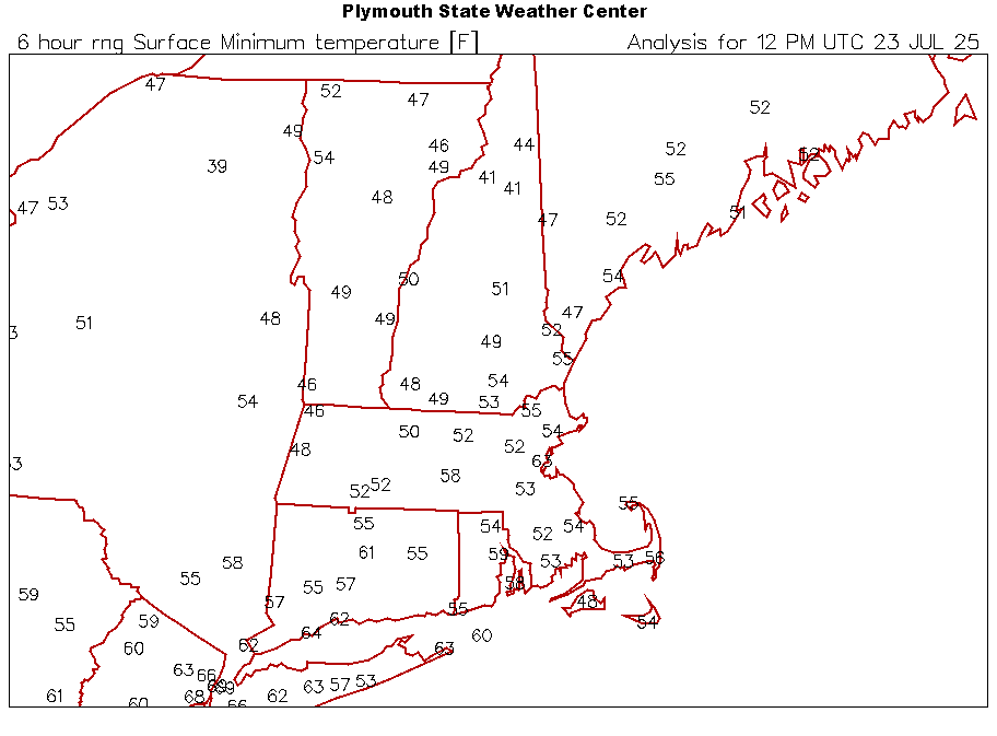
-
If I get lucky and get a 50" winter this season, I would be at exactly normal snow for the decade. Right now I'm averaging 4" below normal from Dec 2020-now
-
July 2025 Obs/Disco ... possible historic month for heat
weatherwiz replied to Typhoon Tip's topic in New England
I really wish alot of these resources were dedicated to what we have an improving on them instead of like "recreating the wheel". One thing I'll say though is regarding severe weather and tornadoes, the amount of data which is being collected on the ground (especially with drones), I would think AI could be used to vastly enhance our understanding of what exactly is occurring leading up to tornadogenesis and help better answer the question of why some mesocyclones will drop a tornado while other's don't. If we can better understand these processes we can then build them into a model and I could see AI yielding some major break throughs. Absolutely agreed with the bolded! -
I lived in New Bern then. We got hit by Hurricane Dennis twice. It first rode up the coast, then stalled and started moving back west for a landfall. I feel like there was another storm. I think it was called Irene...pretty sure. That might be where Graham got the additional rain?
-
i don't think the amo is a real thing
- Today
-
July 2025 Obs/Disco ... possible historic month for heat
MegaMike replied to Typhoon Tip's topic in New England
Logically, it doesn't make sense to me: Let's bring in data scientists to create a stand alone, meteorological modeling system lol. I'm sure it'll get better (build dat' training dataset), but for now, I'd say they're 1-2 decades away from making anything comparable to traditional NWP. I still think using AI to bias correct ic/bcs is the way to go. I know that has merit. Yea, it's a bit misleading... They used HRRR analysis as ground truth to make the conclusion that 'HRRR-Cast is comparable to HRRR...' I'd still rather see evaluations/comparisons at METAR/radiosonde sites. -
Yeah, the record breaking December 2015 +13° around our area seemed to be the very beginning of this shift. We still continued the epic snowfall and benchmark tracks that started in 09-10 until 17-18. Then the rapid jump in the mid-latitude ridging and SSTs began around 18-19. It shifted the winter storm track through the Great Lakes and gave us the record low snowfall for a 7 year period.