All Activity
- Past hour
-

Central PA Summer 2026 Discussion/Obs Thread
mahantango#1 replied to Voyager's topic in Upstate New York/Pennsylvania
Just got 1.28 rain from this batch headed towards Harrisburg area. Complete with several bouts of thunder. It poured. 1.40 for the day. -

2026-2027 Fall/Winter Mountain Thread
buckeyefan1 replied to BlueRidgeFolklore's topic in Southeastern States
CAUTION FOLKLORE—-> I know that you’re supposed to wait until after the first frost, but the persimmons have spoons and the one woolly worm I saw was black Don’t judge I gotta do what I gotta do when it’s the end of September and we’re still 20+ degrees above average every single freaking day -
I think the warm Xmas puns a play off the warm December that is expected....I don't think anyone it honestly trying to forecast down to the day at 3 months out.
-
I don't think you are paying enough attention to antecedent conditions...of course the summer of 2015 was more redolent of El Niño....it came off of....an El Niño with a huge +PDO. You are also misunderstanding what I am saying when I compare to 2015...not just talking about the intensity of the GOA low, but also the degree of MC influence. There is probably a connection, but it's not 1:1. I doubt we see more MC influence than 2015.
-

Septorcher 2026 Discussion - Endless Summer
Lava Rock replied to Damage In Tolland's topic in New England
Missing the good stuff. 0.01". Sent from my SM-S921U using Tapatalk -
DC might be better at sports than we are at December snow.
-

Central PA Summer 2026 Discussion/Obs Thread
canderson replied to Voyager's topic in Upstate New York/Pennsylvania
Yea but 82/76 which is what I’m at now is really gross. -

2026-2027 Record-breaking El Nino
GaWx replied to Stormchaserchuck1's topic in Weather Forecasting and Discussion
Indeed, the weighted avg of your graph, which looks like it is only ~+1.25 to 1.5, doesn’t at all jibe with the image below, which shows it ~+3.3: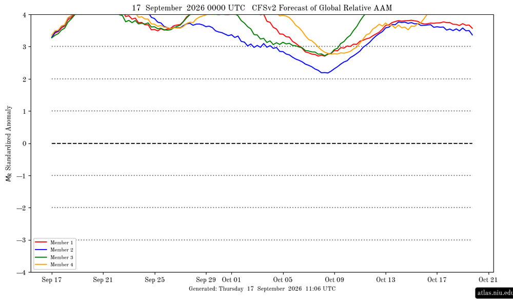
-

2026-2027 Record-breaking El Nino
EasternLI replied to Stormchaserchuck1's topic in Weather Forecasting and Discussion
Yeah IDK just thinking out loud one way I could see it go without too much thought. Actually, the -PDO October might be the best fit for that north Pacific and NA look advertised if we reverse this color scheme accordingly. I'm curious what happens that month as we're really getting into autumn at that point. Not much confidence one way or another. -
Gfs has rain all week next week for the NYC area
-
I honestly don’t think I’ve ever seen one around these parts.
-

Septorcher 2026 Discussion - Endless Summer
JACKASS replied to Damage In Tolland's topic in New England
Misery Mist, useless. -
18z gfs folds. Wet times ahead
- Today
-

Central PA Summer 2026 Discussion/Obs Thread
Superstorm replied to Voyager's topic in Upstate New York/Pennsylvania
The talks of getting to 90F quickly faded today. . -

Septorcher 2026 Discussion - Endless Summer
Damage In Tolland replied to Damage In Tolland's topic in New England
The last week of month and then into Oct does not look cool.. at all -
4.49" on the east side of Huntington since around 10 PM Tuesday evening, 5.11" for the month. I believe that average for FWA for Sept. is only around 3.1".
-
 Viagra online price: GetBelvion - Sildenafil Citrate Tablets 100mg
 -
92 for the high.
-

Septorcher 2026 Discussion - Endless Summer
jlauderdal replied to Damage In Tolland's topic in New England
Sunday is perfection? -
 Historically warm Nino 1+2 in Oct doesn't look like that. Winter, yes, not october based on the last 73 years. I'd say the H5 model you are posting is more opposite than similar in the n. pacific
 -
Sitting at 6.07" of rain in Fort Wayne at my wx station, north of the city. Unreal for September! Miss the blue skies and zzzs we normally get this time of year.
-
Could today have been the last 80 or higher degree day for Central Park this year?
-

Septorcher 2026 Discussion - Endless Summer
dendrite replied to Damage In Tolland's topic in New England
0.10” so far but mod rain Looks pretty cool after Friday with a lot of NE flow next week. -
Ha. I don’t have issues with them although I did have one that was way past ripe and it left me feeling buzzed. Baking with them can definitely give you GI issues. Where did you get yours?
-
2026-2027 Record-breaking El Nino
EasternLI replied to Stormchaserchuck1's topic in Weather Forecasting and Discussion
This GOA low starting to show up as we roll into October. It's kind of something similar to what one would expect to see showing up during el nino in October. Ensembles advertising this look to start out the month. One could say The Aleutian low is simply biased east from the following composite. Thinking that might very well be a plausible idea given the east based nature of this particular event. In addition to the residual state of the north Pacific but let's see how that entire month verifies and evolves. If we envision a roadmap purely from the nino composite, we should see that low eventually retrograde and the ridge just west of the dateline get squashed.