All Activity
- Past hour
-
That's a stein look here, relatively speaking. Just caught myself doing it..stein has really become an overused term. Still wet here, but much more to the west.
-
I'll say though, I think I had a bit of a different mindset on this then I did yesterday. Based on the synoptic look, I am not sure if the placement or even strength of the ULL will matter all too much in terms of sensible weather. We are going to see a flow off the water with sufficient lift so I think it will be wet, just a matter of whether its widespread inches of rain or something less. This is where strength/placement will have the biggest say.
-
I'd like some free water for the plants but whoever put up the drywall to our west did a heckuva job.
-
Another glorious day! Can't beat sunny and 75 at noon I do hope we get some extended rains early next week though -- I'll take the dreariness to get some water in the ground
-
ya it could still move around a bit.. not locking anything in
-
Who’s ready for days and days of cut-off low misery?
-
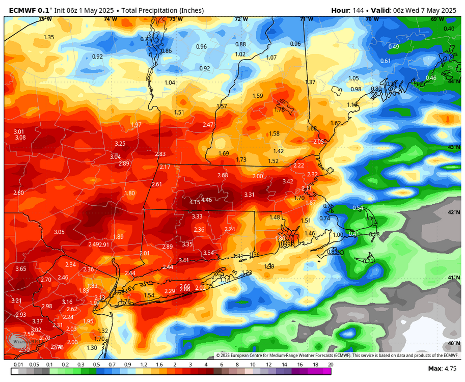
PWAT anomalies +2-3 SD...Monday/Tuesday we may need a boat. We'll see if this signal remains through tomorrow nights runs
-
most of that falls by late Tuesday night
-
Stein
.thumb.png.adf09b028a11e204729e2f54bfa07712.png)
-
going to need a boat if the 12z Icon is right
-
Ill take it all year.. the only time the heat is good is at the beach
-
Recorded 0.12" yesterday to bring my April total to 3.13" Highest temp 84f; lowest 28
-
Just a sick and deranged individual in regards to that . Cannot fathom wishing for chill and rain in summer. You get enough of it in winter
- Today
-
it keeps the big heat away a little longer.. this thing can sit and spin for a month for all I care.. it wont rain all the time but temps will be kept down
-
Maybe. Maybe not. Why are you so invested in this and rain? It’s summer
-
Yea that would be less than idea.
-
even if the heaviest is west you'll still get 1 to 2 by Wednesday.. Stein dead
-
up to 0.79" this morning with more showers throughout the next 2 days.
-
12z NAM seems to back up the 00z globals in showing more to the west of 95 (through 00z monday)
-
Does anyone think the severe risk will shift a little east later today?
-

Central PA Spring 2025
Itstrainingtime replied to canderson's topic in Upstate New York/Pennsylvania
Not really a forecast per se but I haven't forgotten this post. Three wasn't a whole lot of model consensus at the time but everything has come around to it over the past several days. -
The whole thing is way west. You can see the setup. Rain sets up ENY into S VT. Classic look while east Steins
-
Let’s get water flowing out of hillsides in Tolland.
-
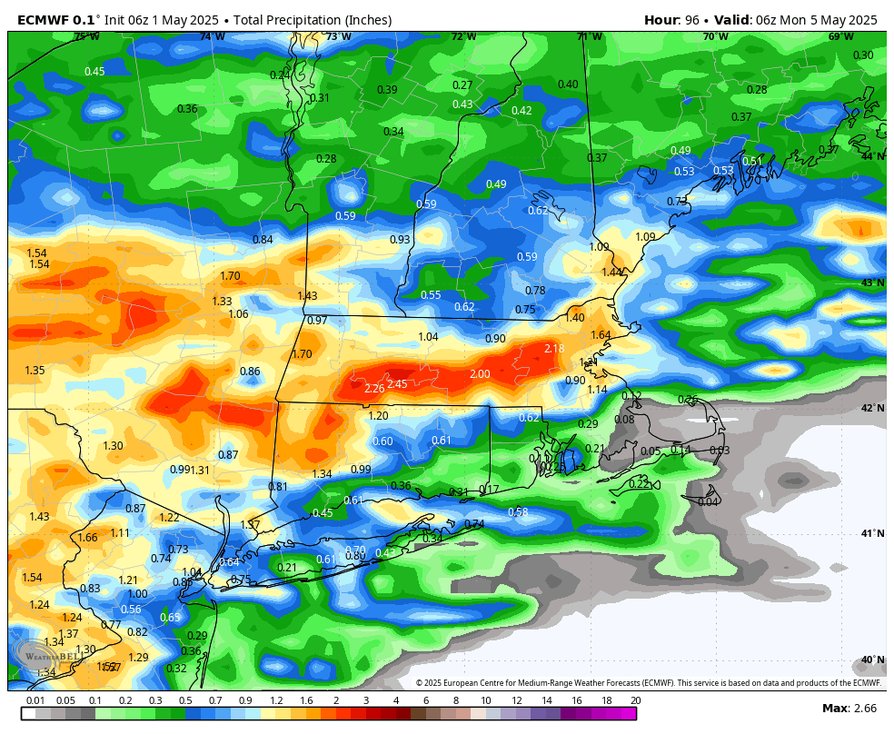
This is through 6z Monday. Overall looks Steiny through Tuesday night.

-
It does specify both afternoons as when showers are likely but I think right now it's too difficult to pinpoint


.png.e83292b5665d5efb4456fe3f382a8b89.png)