All Activity
- Past hour
-
AL, 06, 2025082318, , BEST, 0, 266N, 617W, 35, 1010, TS, 34, NEQ, 0, 90, 0, 0, 1015, 110, 90, 0, 0, L, 0, , 0, 0, FERNAND, S, 0, , 0, 0, 0, 0, genesis-num, 019, TRANSITIONED, alB02025 to al062025,
-
 Clouded up a bit here in CNJ in the last hour. As seen on the vis loop, should move through S->N
 -
Hotter than expected. High of 86f Sent from my SM-S921U using Tapatalk
-
I just remember my cup of water shaking like it was Jurassic Park.
-
It’ll be a nice and warm fall and I’m sure we’ll have some hot days in there, but we’ve stepped down. It’s undeniable.
-
These dews are just the chefs kiss on the day.
-
That’s why so many people are moving out to the Desert Southwest. Many people are OK with the extreme summer heat and drought. Then they can take weekend ski trips during the winter to get their fill of snow and cold.
-
We do?
-
That’s a really good point. As I saw it the two big killers right now would have been vorticity stretching and the drier air/SAL. So far 99L has held on. Would’ve been much harder to do if it wasn’t so organized. Now that’s interesting. GEFS have very little, if any, signal.
-
had a yard work day, wasn’t expecting to see 90. I’m toast
-
Not to brag, well maybe just a little, but it has been a good summer for moisture up here. I closed out July with 2.3”. It has been a bit dry in mid August but have picked up .4” recently and I am rather optimistic for more over the next few days.
-
We’re going to pay dearly for this pleasant weather in Sept and Oct aren’t we?
- Today
-
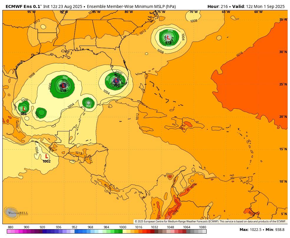
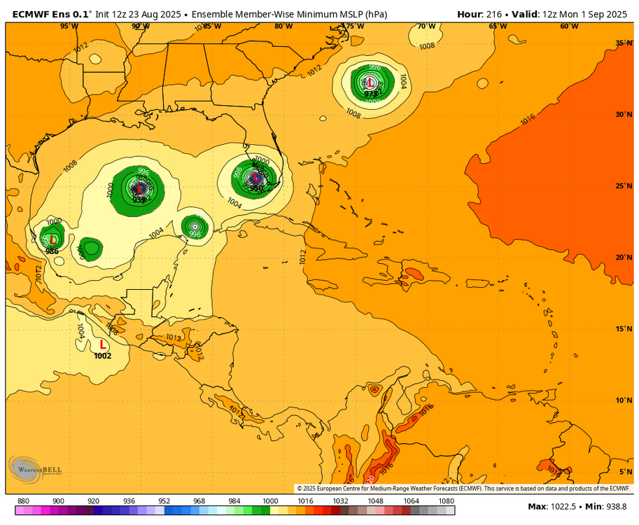
In addition to the 12Z Icon being still another of its runs developing this in the W Caribbean, the 12Z Euro ens is significantly more active:
-

Occasional Thoughts on Climate Change
donsutherland1 replied to donsutherland1's topic in Climate Change
So far, the ECMWF is an outlier in terms of a return to extreme heat, but the period looks abnormally warm. We'll see what the 12z ECMWF shows. I agree with you about the changes in climate classifications. The warming is ongoing and fairly dramatic. At least one episode of extreme heat has become a fairly regular occurrence. The number of hot days has increased markedly. -
83 / 54 great day
-
https://x.com/convchronicles/status/1959276496687903012?s=46&t=nTdsbQZkQMPkUI3zGjAXJg convective chronicles is planning on uploading a case study on the may 31st 1985 tornado outbreak i figured that yall would be interested looking back on it with the case study
-

Central PA Summer 2025
Mount Joy Snowman replied to Voyager's topic in Upstate New York/Pennsylvania
Just mowed, what a phenomenal day. Time for some libations and grilling. Next week is going to be heavenly. -
yes this looks pretty good. Still firing deep convection which is the most important thing. This def was a TD/TS a few days back which might speak to why it’s still holding together so well now
-
We march toward fall.
-
NNE cooking again. Deep summer day near 90°
-
I take it ultra warm winters like 11-12, 15-16, 19-20, 22-23, 23-24 were more or less unprecedented before this era no? It's not just that though. 21-22 and 24-25 were decently cold/seasonable, we just can't buy a big storm or frequent moderate storms anymore :/. Sucks and makes me want to move up north to VT or something.
-
This was posted on IND's fb page. Make of it what you will.

-
TS likely per NHC. Euro really struggled with its TC genesis signal here (and 99L surviving this long). Southwestern Atlantic (AL90): Satellite images and Air Force Reserve aircraft reconnaissance data indicate that an area of low pressure about 400 miles south- southeast of Bermuda continues to get better-defined, and recent satellite-derived winds indicate that the low pressure area has gale-force winds east of the center. This system is expected to become a tropical storm this afternoon or evening, with further intensification likely through Sunday while the low moves northward at 10 to 15 mph over the southwestern Atlantic. Interests in Bermuda should monitor the progress of this system, though the threat to that island appears to be less than yesterday. For additional information, including gale warnings, please see High Seas Forecasts issued by the National Weather Service. * Formation chance through 48 hours...high...near 100 percent. * Formation chance through 7 days...high...near 100 percent.
-
 This. I think we're cooked until the western pac stops boiling. Has there been a single extreme -pdo type winter that ended up good for us??