All Activity
- Past hour
-

First Winter Storm to kickoff 2025-26 Winter season
dendrite replied to Baroclinic Zone's topic in New England
Wish the 3k went out further…it was looking more realistic. -
-

First Winter Storm to kickoff 2025-26 Winter season
ineedsnow replied to Baroclinic Zone's topic in New England
Hopefully the Euro tends north today.. in leominster and starting to snow a bit -
First Winter Storm to kickoff 2025-26 Winter season
radarman replied to Baroclinic Zone's topic in New England
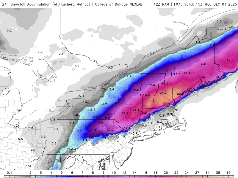
Agree. Take that snow map, divide it by 2.5, tick it a hair SE and call it a day -

First Winter Storm to kickoff 2025-26 Winter season
dendrite replied to Baroclinic Zone's topic in New England
GC is a special place. -

First Winter Storm to kickoff 2025-26 Winter season
dendrite replied to Baroclinic Zone's topic in New England
We are due for the gfs and euro to flip their positions. Let’s get the gfs way SE and then the euro way NW to cause even more confusion. -

First Winter Storm to kickoff 2025-26 Winter season
moneypitmike replied to Baroclinic Zone's topic in New England
Seeing as how "named storms" is an aspect of property insurance, there's inherent and unintended (?) implications for home owners. Meanwhile, I'll take the NAM and run. -

E PA/NJ/DE Winter 2025-26 Obs/Discussion
donsutherland1 replied to LVblizzard's topic in Philadelphia Region
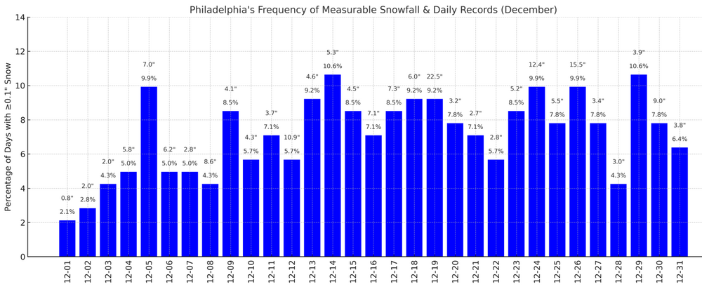
Some December Snowfall Statistics: For Philadelphia, the December date(s) with the highest frequency of each snowfall threshold is: Measurable snowfall: December 14 and December 29: 15 occurrences 1.0" or more snow: December 5 and December 26: 10 occurrences 6.0" or more snow: December 19 and December 26: 3 occurrences 10.0" or more snow: December 26: 2 occurrences -
Snowing
-

E PA/NJ/DE Winter 2025-26 Obs/Discussion
Birds~69 replied to LVblizzard's topic in Philadelphia Region
-
very light sow. Started around 9.
-

First Winter Storm to kickoff 2025-26 Winter season
Damage In Tolland replied to Baroclinic Zone's topic in New England
It’ll be over Tuesday night prior to midnight . Pony o’s will be seen shoveling that night -

First Winter Storm to kickoff 2025-26 Winter season
CoastalWx replied to Baroclinic Zone's topic in New England
NAM is definitely on edibles with that QPF. -

First Winter Storm to kickoff 2025-26 Winter season
CoastalWx replied to Baroclinic Zone's topic in New England
21” MHT. “I’m fine with the ground whitening..” -
-
Even they said wtf.. It's snowing.!
-

First Winter Storm to kickoff 2025-26 Winter season
Damage In Tolland replied to Baroclinic Zone's topic in New England
The thing is. The NAM’s not done coming south and East -

First Winter Storm to kickoff 2025-26 Winter season
ineedsnow replied to Baroclinic Zone's topic in New England
Starts late Tuesday morning -
E PA/NJ/DE Winter 2025-26 Obs/Discussion
Kevin Reilly replied to LVblizzard's topic in Philadelphia Region
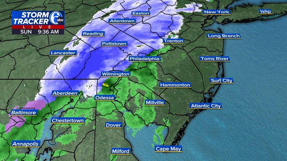
36f Dewpoint 27 light snow This was NOT on my bingo card today! -
.thumb.png.4150b06c63a21f61052e47a612bf1818.png)
First Winter Storm to kickoff 2025-26 Winter season
HIPPYVALLEY replied to Baroclinic Zone's topic in New England
Whatever happens, I’m not real concerned about precipitation type issues in Greenfield. Should be a snowy Wednesday morning whether it’s 2” or 10”. -
This is crazy. Snow/sleet this morning and I’m close to the dark blue in that map. I’ll eat Terpseast’s shoes.
-

First Winter Storm to kickoff 2025-26 Winter season
Damage In Tolland replied to Baroclinic Zone's topic in New England
With a retreating high I’ll sell for now . -

First Winter Storm to kickoff 2025-26 Winter season
ineedsnow replied to Baroclinic Zone's topic in New England
Would be nice to get paste and then tear some trees down -

First Winter Storm to kickoff 2025-26 Winter season
dendrite replied to Baroclinic Zone's topic in New England


