All Activity
- Past hour
-
Euro
-
You should go to the Washington game next year Sent from my SM-G970U1 using Tapatalk
-

September 2025 OBS-Discussion centered NYC subforum
LibertyBell replied to wdrag's topic in New York City Metro
January 1985 had our deepest arctic outbreak though and that's the one I remember. The last time JFK went below 0. The high was in the single digits too, which is extremely rare here. -
September 2025 OBS-Discussion centered NYC subforum
LibertyBell replied to wdrag's topic in New York City Metro
Sounds like April 1982 when EWR had 13 inches of snow and the rest of us had 8-10 lol. I do recall some place on Long Island had 16 inches, but I don't remember where. -
September 2025 OBS-Discussion centered NYC subforum
LibertyBell replied to wdrag's topic in New York City Metro
Weird and NYC only had 1? 1993-94 was better in that regard, NYC had 3. -
3-6 cases
-
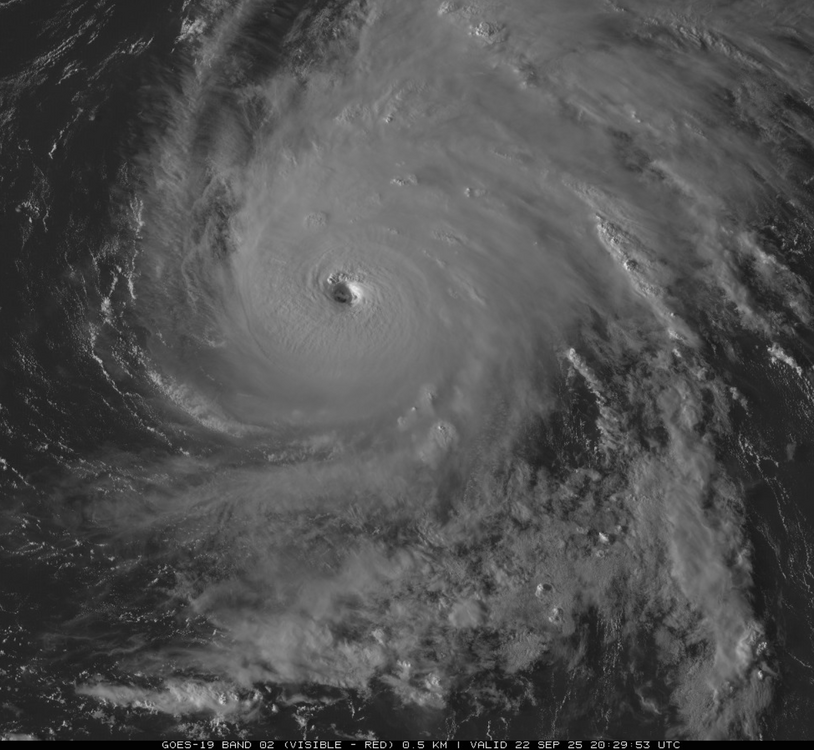
Hurricane Gabrielle Discussion Number 24 NWS National Hurricane Center Miami FL AL072025 500 PM AST Mon Sep 22 2025 Gabrielle has continued to become better organized this afternoon, with very cold cloud tops in the eyewall and a warm eye. Data from both NOAA P-3 Hurricane Hunter aircraft confirm satellite estimates that Gabrielle is a category 4 hurricane, with peak 700-mb winds of 129 kt in the eastern quadrant a few hours ago. Additionally, tail-Doppler radar data showed maximum 0.5 km winds of 135-140 kt on the last pass, and the double eyewall structure has consolidated into a single eyewall again. These data supported an intensity of at least 115 kt at 18Z, and with the slight improvement on satellite since that time, the initial wind speed is set to 120 kt. The hurricane is moving to the north-northeast at about 10 kt. There are no important changes to report to the track forecast, with the subtropical ridge providing a seemingly reliable steering for the next several days. Gabrielle is forecast to turn northeastward overnight and then move at a more rapid pace to the east-northeast during the next few days due to stronger mid-latitude flow. The new forecast remains on the faster side of the guidance, closer to the Google DeepMind and GFS model. Extratropical transition is expected late on Friday while the system is in the vicinity of the Azores. Little significant intensity change with Gabrielle is expected as the cyclone begins to move into a less conducive environment, though the overnight diurnal convective max should help the hurricane maintain its strength in the short term. A combination of cooler waters and increasing shear should cause Gabrielle to start to weaken by late tomorrow. While SSTs drop off notably by midweek, an upper-level trough is likely to provide extra divergence aloft, keeping the hurricane stronger than other environmental conditions might suggest. The new NHC intensity forecast is quite similar to the previous one, showing a gradual weakening during the long-range forecast and near the model consensus. KEY MESSAGES: 1. Swells generated by Gabrielle will continue to affect Bermuda and the east coast of the United States from North Carolina northward, as well as Atlantic Canada, during the next couple of days. These swells are likely to cause life-threatening surf and rip current conditions. Please consult products from your local weather office. 2. Gabrielle is forecast to approach the Azores late on Thursday. Interests in the Azores should monitor the progress of Gabrielle though it is too soon to specify the magnitude of potential wind, rainfall, and wave impacts. FORECAST POSITIONS AND MAX WINDS INIT 22/2100Z 31.7N 61.8W 120 KT 140 MPH 12H 23/0600Z 32.8N 60.4W 120 KT 140 MPH 24H 23/1800Z 34.2N 57.5W 110 KT 125 MPH 36H 24/0600Z 35.2N 53.0W 100 KT 115 MPH 48H 24/1800Z 35.7N 47.3W 90 KT 105 MPH 60H 25/0600Z 36.3N 40.7W 80 KT 90 MPH 72H 25/1800Z 37.7N 34.0W 70 KT 80 MPH 96H 26/1800Z 42.8N 22.9W 60 KT 70 MPH...POST-TROP/EXTRATROP 120H 27/1800Z 44.5N 15.0W 45 KT 50 MPH...POST-TROP/EXTRATROP $$ Forecaster Blake
-
3-6 beers?
-
Nice looking fish food as the sun sets...
-
Beer? Beer.
-
Umm... Not sure what you're looking at, but what I see doesn't show anything 3" to 6" in anywhere in the entire Northeast and Mid-Atlantic.
-
Seems like a fairly widespread rain..obviously some winners and losers...but between tomorrow and Friday many areas get wet.
-
36 to 69 here, total sun thru 3:30 with some high clouds sifting in since then. Sandy flow is down to 42 cfs, probably about 5th percentile as the record low (in 1939) is 33 and 25th is 78.
-
Sun making a late afternoon appearance!
-

September 2025 OBS-Discussion centered NYC subforum
Brian5671 replied to wdrag's topic in New York City Metro
We were the first stop in the morning and we lived close to the bus yard-the bus had the heat on by the time it reached us, but the seats were frozen solid. Ah the memories... -
-

September 2025 OBS-Discussion centered NYC subforum
bluewave replied to wdrag's topic in New York City Metro
I mostly remember how cold it was waiting for the school bus every morning during those late 70s winters. - Today
-

September 2025 OBS-Discussion centered NYC subforum
steve392 replied to wdrag's topic in New York City Metro
I was still just a twinkly in my dad's eye that winter LOL -

September 2025 OBS-Discussion centered NYC subforum
donsutherland1 replied to wdrag's topic in New York City Metro
It will turn noticeably warmer tomorrow before a weak cool front crosses the region on Wednesday. Highs tomorrow will likely reach the lower 80s with some middle 80s in the warmer spots. The advancing front could trigger some showers or thundershowers. Additional rain is possible Thursday into Saturday as a series of low pressure systems move along the frontal boundary. The ENSO Region 1+2 anomaly was 0.0°C and the Region 3.4 anomaly was -0.4°C for the week centered around September 17. For the past six weeks, the ENSO Region 1+2 anomaly has averaged -0.03°C and the ENSO Region 3.4 anomaly has averaged -0.38°C. La Niña conditions will likely develop during mid- or late-autumn. The SOI was -1.19 today. The preliminary Arctic Oscillation (AO) was +1.147 today. Based on sensitivity analysis applied to the latest guidance, there is an implied near 58% probability that New York City will have a warmer than normal September (1991-2020 normal). September will likely finish with a mean temperature near 69.4° (0.2° above normal). Supplemental Information: The projected mean would be 1.4° above the 1981-2010 normal monthly value. -
Nothing shows 3-6”
-
Some do. I curse it.
-
What else shows 3-6” in all areas?
-
September 2025 OBS-Discussion centered NYC subforum
bluewave replied to wdrag's topic in New York City Metro
Still the record for number of days with lows at or below 0° at Islip. Time Series Summary for ISLIP-LI MACARTHUR AP, NY - Dec through Feb Days with low temperature at or below 0° Click column heading to sort ascending, click again to sort descending. 1 1978-1979 6 0 2 1964-1965 4 0 3 1967-1968 3 0 - 1966-1967 3 0 4 1987-1988 2 0 - 1983-1984 2 0 - 1981-1982 2 0 - 1980-1981 2 0 5 2015-2016 1 0 - 2013-2014 1 0 - 1984-1985 1 0 - 1976-1977 1 0 - 1975-1976 1 0 - 1973-1974 1 0 - 1969-1970 1 0 - 1963-1964 1 2 Data for December 1, 1978 through February 28, 1979 Days with low temperature at of below 0° Click column heading to sort ascending, click again to sort descending. NY WALDEN 1 ESE COOP 16 NJ CANOE BROOK COOP 11 NJ CHARLOTTEBURG RESERVOIR COOP 11 NY YORKTOWN HEIGHTS 1W COOP 11 NY CARMEL COOP 10 CT NORWALK GAS PLANT COOP 9 NY WESTCHESTER CO AP WBAN 9 NY PORT JERVIS COOP 8 NJ CRANFORD COOP 8 NJ LITTLE FALLS COOP 8 NJ WANAQUE RAYMOND DAM COOP 8 NY SUFFERN COOP 8 CT MIDDLETOWN 4 W COOP 8 CT NORWICH PUBLIC UTILITY PLANT COOP 8 NJ JERSEY CITY COOP 7 NY MIDDLETOWN 2 NW COOP 7 CT STAMFORD 5 N COOP 7 CT DANBURY COOP 7 NY SCARSDALE COOP 7 CT MOUNT CARMEL COOP 7 CT GROTON COOP 7 NJ PLAINFIELD COOP 6 NY WEST POINT COOP 6 NY PATCHOGUE 2 N COOP 6 NY ISLIP-LI MACARTHUR AP WBAN 6 NJ NEWARK LIBERTY INTL AP WBAN 5 NY DOBBS FERRY-ARDSLEY COOP 5 NY VANDERBILT MUSEUM COOP 5 CT NEW HAVEN COOP 5 NY SETAUKET STRONG COOP 5 Data for December 1, 1978 through February 28, 1979 Days with low temperature at or below 0° Click column heading to sort ascending, click again to sort descending. PA BELTZVILLE DAM COOP 16 PA TOBYHANNA POCONO MOUNTAIN ARPT WBAN 14 NJ LONG VALLEY COOP 13 NJ NEWTON COOP 13 NJ SUSSEX 1 NW COOP 13 PA COATESVILLE 1 SW COOP 10 NJ FLEMINGTON 5 NNW COOP 10 PA READING 4 NNW COOP 10 NJ HIGH POINT PARK COOP 10 NJ FREEHOLD-MARLBORO COOP 9 NJ SOMERVILLE 4 NW COOP 9 NJ MORRIS PLAINS 1 W COOP 9 PA EAST STROUDSBURG COOP 9 NJ BELVIDERE COOP 9 -
-
Yes. I live 1 mile from there. Was a slightly eerie 2 hours when they thought there was a 2nd shooter on the run.


