All Activity
- Past hour
-
The windshield wiper effect is strong with this one. We are only 4 days out and I have no idea what is going to happen. We just don’t know……
-
26/25°F, 0.50" of snow before the flip to FRZRN.
-
Turned into a pretty snowy evening for NW burbs especially with some elevation. As already mentioned, the NAM, GFS, and ECM did pretty good along the southern periphery of snow. HRRR and RGEM not so much - too warm. Apart from the ECM and ECM-AI (haven't seen?), 18z wasn't great for this weekend's potential event.
-
Kudos to Vernon Township DPW. They are in my neighborhood now. 2nd time plowing and salting. Roads are perfect.
-
Wantage NJ (this southern part at 740' MSL). 1.8" final-wet clingy snow. Less on driveway and virtually none on paved roads now... temp rising to 32.4F.
-
Can’t wait to see the pics from this group. It’s about to absolutely crank.
-
Long Island
-
lol, I thought it was going to be bad. I'd take that in a heartbeat
-
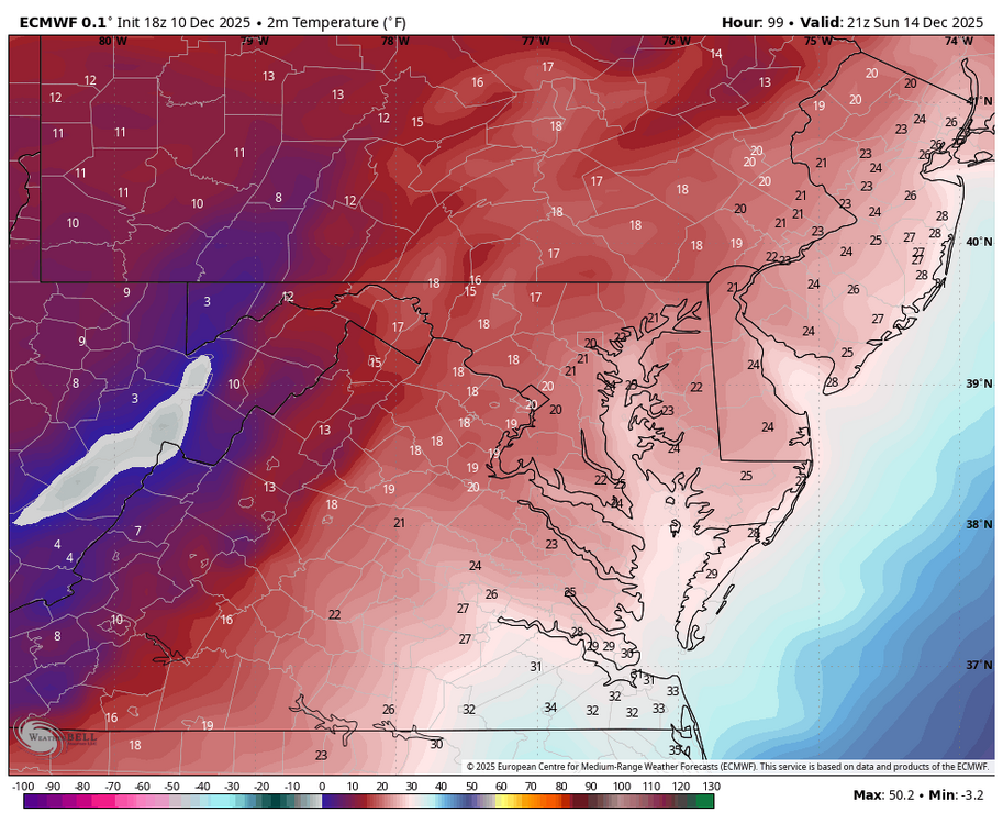
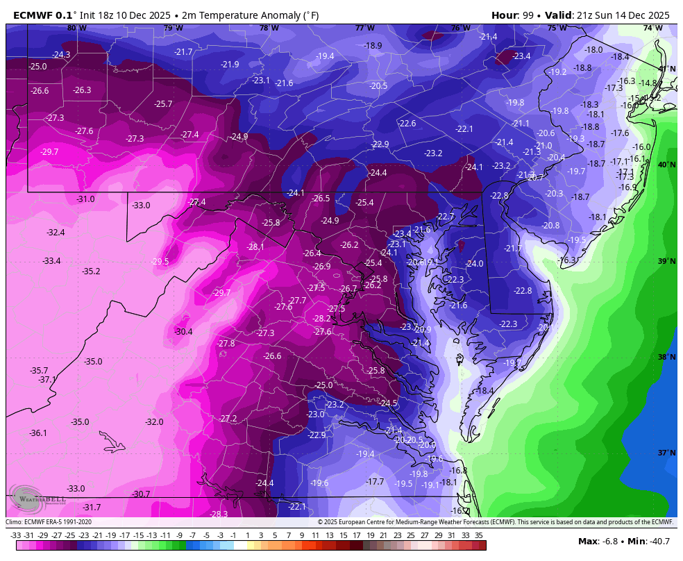
Gosh folks, the big story is how bitterly cold the WB 18Z EURO is for Sunday afternoon....remember the years when we would go weeks without going below freezing?!!!!

-
Moderate rain. Very few wet flakes/white rain mixing in.
-

Central PA Winter 25/26 Discussion and Obs
NepaJames8602 replied to MAG5035's topic in Upstate New York/Pennsylvania
Right around 2.5" inches of snow today from the clipper in my part of the Poconos. Great snow pack refresher! Sitting at around 12.0" for the season now. -
Still some flakes falling, but it's basically over. 1.8" total. 32.4 5.1" season total so far.
-
Looks just fine to me.
-

December 2025 regional war/obs/disco thread
moneypitmike replied to Torch Tiger's topic in New England
Nice temp spike--suddenly up to 42.
-

Minor snow possible sunday 12/14/25
RU848789 replied to WeatherGeek2025's topic in New York City Metro
This can't be a serious post. GFS has been all over the map, while the Euro and AIFS have been fairly consistent for a light to moderate snowfall for a few runs and the CMC came on board at 12Z and the UK almost did too (after showing nada for several runs). And the NAM/RGEM at 84 hours (yes, questionable) look very similar to the Euro at 84 hours with snow on our doorstep at 06Z Sunday. Certainly not a lock yet 3+ days out, but confidence is much greater than 24 hours ago. - Yesterday
-
@The 4 Seasons picked up 1.1" here today as this winds down giving me 4.5" for the season. 33/31 currently with just some light flurries lingering.
-

Minor snow possible sunday 12/14/25
BxEngine replied to WeatherGeek2025's topic in New York City Metro
Are you ok? -

December 2025 Short/Medium Range Forecast Thread
Jed33 replied to John1122's topic in Tennessee Valley
A heavy sleet band just plowed through I mean just smoked us! Only problem was it only lasted for about a minute or so. It was cool while it lasted. Tried to coat the walkway and grass. The temp fell from 40 to 38 during the time. That was unexpected, at least by me! -
Minor snow possible sunday 12/14/25
RU848789 replied to WeatherGeek2025's topic in New York City Metro
Yes it is and AIFS is good too, while the volatile GFS remains all over the place. I like these more local maps, but keep in mind that this map still includes an inch or two N of 84 for many today, but it's just the Sunday event for anywhere near and SE of 95. -
I’d call it something else consider us northern crew have had Lucy screw us over more then enough.
-
warmer but qpf nearly identical
-
So 18z euro is drier, warmer, about the same, or best yet?
-
Yeah most of SNE is prob advisory that run outside of far NW areas maybe….then you maybe get into low end warning in SE areas. Way too early to worry about amounts though. We can’t even get guidance to agree on if a system will even hit us.
-
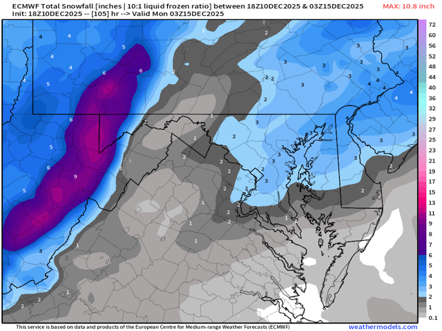
With such a narrow "win" zone it is going to be tough to please everyone. I'll hug the 18z euro because it is the best run for NW zones so far. Not going to jack out this way, just trying to get in on the action and have if look like winter.


.thumb.jpeg.f5c6ba9d911ec96b3b124f8606aee58e.jpeg)