All Activity
- Past hour
-
i'm almost thinking the Senators won't rain out todays afternoon game, finally a day game
-
Drove through Ridgely(along Rt 480) on my way to work and there was some significant damage to several larger trees and plenty of other tree debris scattered around. That's a little south of the Mesonet station. My guess is winds probably gusted 60+ in that area.
-
am rushing so won't make a final decision for 2-3 100F days M-W KEWR area (interior NJ in our subforum). Probably a pretty good chance for NYC to get at least one but want to rereview at 9P. Heat wave officially begins interior NJ Suun, possibly touching 90 Sat). HW ends sometime between Thu-Sat next week dependent on backdoor. No time to assess SVR. Use among your tools SPC and BOM. Have a day, Walt
-
So 2-3 days?
-
68/67…soupy. But I see Sun, and that should burn off the fog and launch temps. Would be nice to let the lawn dry a little bit before mowing.
-
Man next week is trending extremely hot again.. high end heat and humid
-
Min 64.9° Not too bad out…a little sticky. Feels like summah.
-
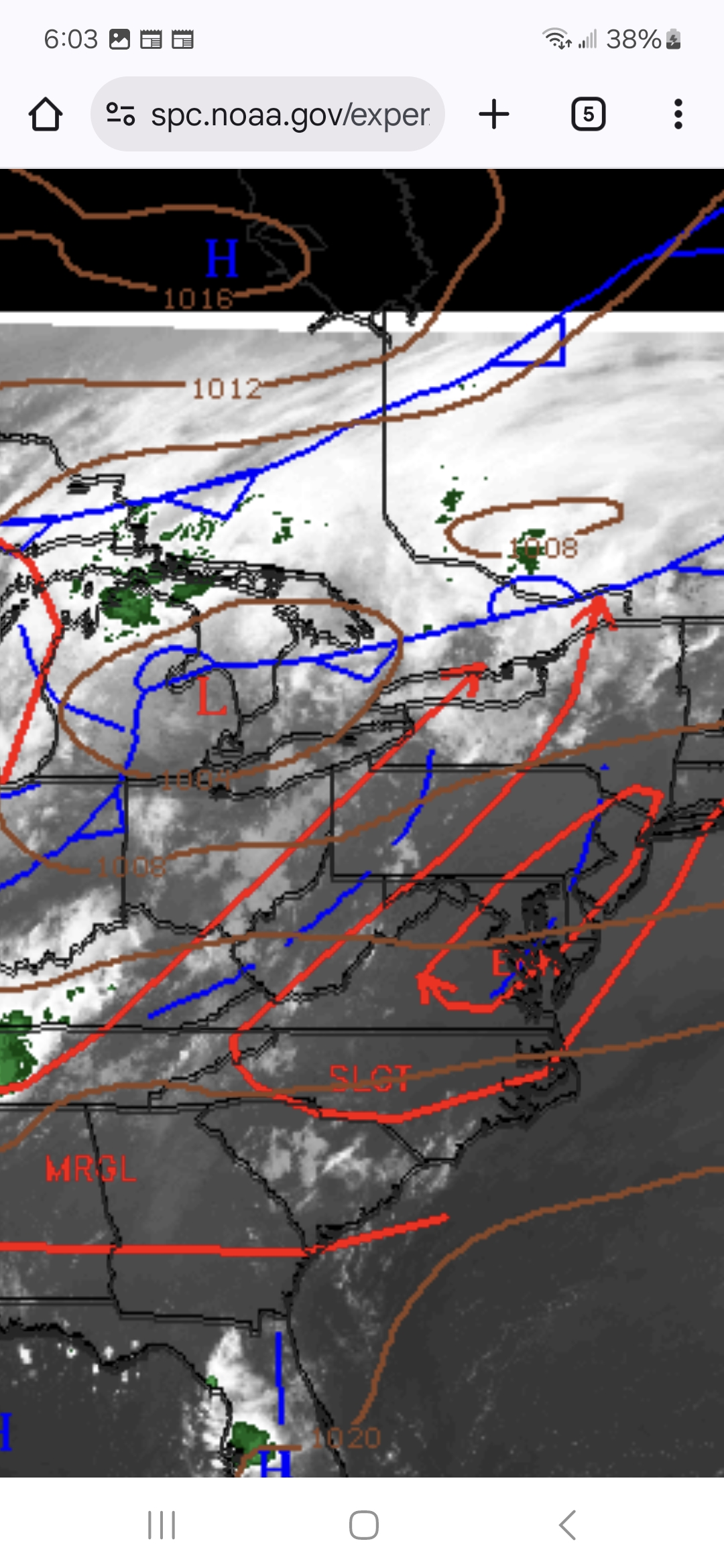
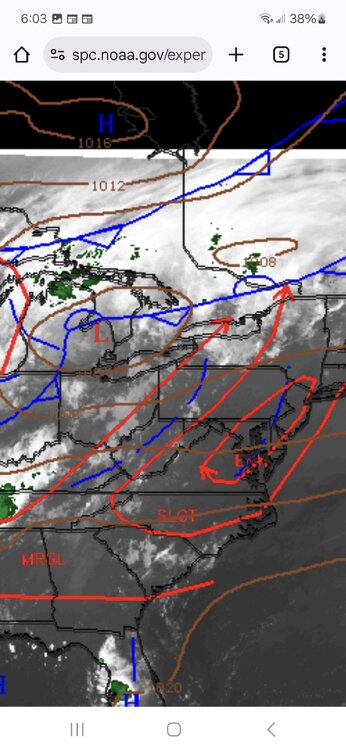
I'm trying out an experimental tool from the spc to do some overlays. Clear blue out ahead of the pre frontal with clearing skies ahead the main front. Apparently there will be enough destabilization storms will initiate on both, but at the end of the day, the closer the storms initiate to the main front the better if you want more robust and mature storms further west and east. So I'm hoping to see a majority of convection break out along the CF and less along the PFT. Hope and expectations are two different things.
-
0.69” with the last storm yesterday evening 1.4” for the day
-
What?
-
drinking some vodka and crans later, hopefully watching WNE get croaked. Maybe Wiz finds his 62kt gust. Either way great HHH work holiday at the beach.
-
Yep we steam.
-
Just got out and enjoyed my favorite weather with a 4 mile run to start the day. Feels awesome out thrrr
-
uh, its sunny here.
-
Actually, I already have some breaks in the overcast here.
-
Upgraded to enhanced. Good call
- Today
-
Expected. Clear out after 9-10.
-
Looks like the heat is cut off Wed into Friday perhaps with Wednesday still possible 90 in CT. By srly July Rickie’s ridge develops again which will put a lid on temps for us but may turn more humid too.
-
Nothing screams big SNE severe outbreak than dense, pea soup fog and mist to start the day .
-
Time to start heating the lake up for late summer swimming
-
Also from the spc ..Eastern U.S... Seasonally strong upper trough is currently located over IL and should advance into the OH Valley by 18z as stronger 500mb flow develops across western PA/NY. With time, 50+kt flow should translate into the Middle Atlantic, coincident/just ahead of the primary synoptic front. Latest model guidance suggests modest 0-3km lapse rates will develop by mid day as the boundary layer warms ahead of the wind shift, especially from the Carolinas into Upstate NY. In fact, much of the I-95 corridor over the Middle Atlantic will warm quickly through the 80s to near 90F, effectively removing any inhibition. As a result, convection should readily develop within a very moist environment (PWs 1.75-2 inches) characterized by MLCAPE in excess of 2000 J/kg. Forecast soundings exhibit deep west-southwesterly flow with 0-6km bulk shear around 30kt. These profiles favor organized line segments and clusters, and severe wind gusts will likely be noted with the most robust activity. Convection should spread off the Middle Atlantic Coast during the evening hours. Full discussion from the spc is in the link below https://www.spc.noaa.gov/products/outlook/day1otlk.html
-

June 2025 discussion-obs: Summerlike
LongBeachSurfFreak replied to wdrag's topic in New York City Metro
Flash flood event building over the city and western Long Island right now. Stationary convection firing. Could seed the atmosphere for later today. Might actually be a radar issue. -
NOAA NWS Storm Prediction Center rsooendptS93ll8l6h0ia7ih8m02l1ft471839mg0lah48h73ghu4fhflf88 · 6/19 2:40 AM EDT: Scattered strong to severe thunderstorms appear likely today across much of the Mid-Atlantic region, and also parts of the Carolinas and New England. The severe risk should peak this afternoon and evening, before convection moves offshore or weakens. Scattered to numerous severe/damaging winds will likely be the primary risk with these thunderstorms, but isolated hail and perhaps a tornado or two may also occur.
-
571 FXUS61 KCTP 190813 AFDCTP Area Forecast Discussion National Weather Service State College PA 413 AM EDT Thu Jun 19 2025 .SYNOPSIS... -- Changed Discussion -- * Strong to severe thunderstorms possible this afternoon and evening particularly across the southeast half of central PA * Not as humid for the first day of summer on Friday with a couple of passing rain showers/isolated gusty thunderstorm * Trending warmer to start the weekend with a major to extreme heat risk Sunday through next Wednesday -- End Changed Discussion -- && .NEAR TERM /THROUGH TONIGHT/... -- Changed Discussion -- Muggy start today with sunrise temps in the 65-70F range and fog in the central and eastern ridge/valley region. High PW axis aligned with strong isentropic lift/WAA pattern on nose of 40-50kt 850mb jet will likely keep a few showers going across the western Alleghenies early this morning. Focus will shift to severe t-storm risk for later this afternoon/evening. Seasonally strong upper trough located over IL at 06Z will advance into the Upper OH Valley by 18z as stronger 500mb flow develops across western PA/NY. Convection should readily develop along and just ahead of an eastward advancing cold front or prefrontal trough within a very moist/unstable environment particularly near max PWAT/CAPE bullseye over the southeastern half to 1/3 of central PA. SPC has maintained a level 2 out of 5 risk over most of this area, but did increase the severe threat to level 3 of 5 (ENH) along the I95 corridor which does clip York and Lancaster Counties. Severe wind gusts remain the primary concern with deep shear profiles favoring organized line segments and clusters. HREF data indicates storms exit the Lower Susq Valley after 00Z with any lingering shower activity fading by late tonight/06Z Fri. Flash flood risk should be reduced to some extent today with more progressive storm motions perpendicular to the front. However, with high PWs 1-2 inches, extremely sensitive/primed soils, and significantly reduced 1hr FFG as low as 0.5" (thanks to 7-day rainfall 200-400 percent of normal) an isolated flash flood is possible particularly in the most vulnerable/wettest locations across the Laurel Highlands and south central Alleghenies. Post frontal WNW flow will direct drier air (lower Td/PW) into CPA overnight with low temps falling back into a more comfortable mid 50s to low 60s range or 5-10 degrees cooler than last night. This flow may also bank low clouds along the Allegheny Front beneath subsidence inversion associated with sfc ridge axis extending northward from 1020mb high pressure over the Central Appalachians.
-

Central & Eastern Pacific Thread
BarryStantonGBP replied to Windspeed's topic in Tropical Headquarters
Hurricane Erick Satellite | Buoys | Grids | Storm Archive Special Advisory products have been issued. Use links below for details. ...ERICK NOW AN EXTREMELY DANGEROUS CATEGORY 4 HURRICANE... 12:00 AM CST Thu Jun 19 Location: 15.5°N 97.5°W Moving: NW at 9 mph Min pressure: 939 mb Max sustained: 145 mph Public


.thumb.jpg.6a4895b2a43f87359e4e7d04a6fa0d14.jpg)