All Activity
- Past hour
-
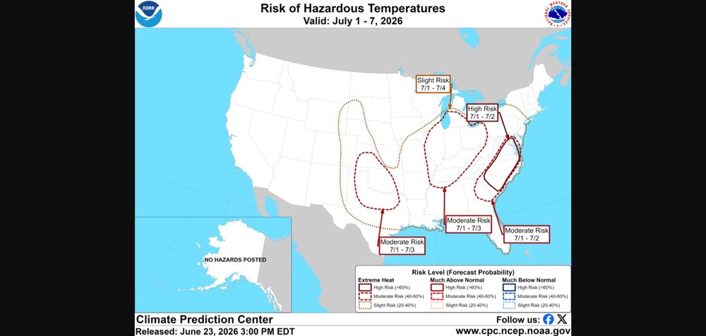
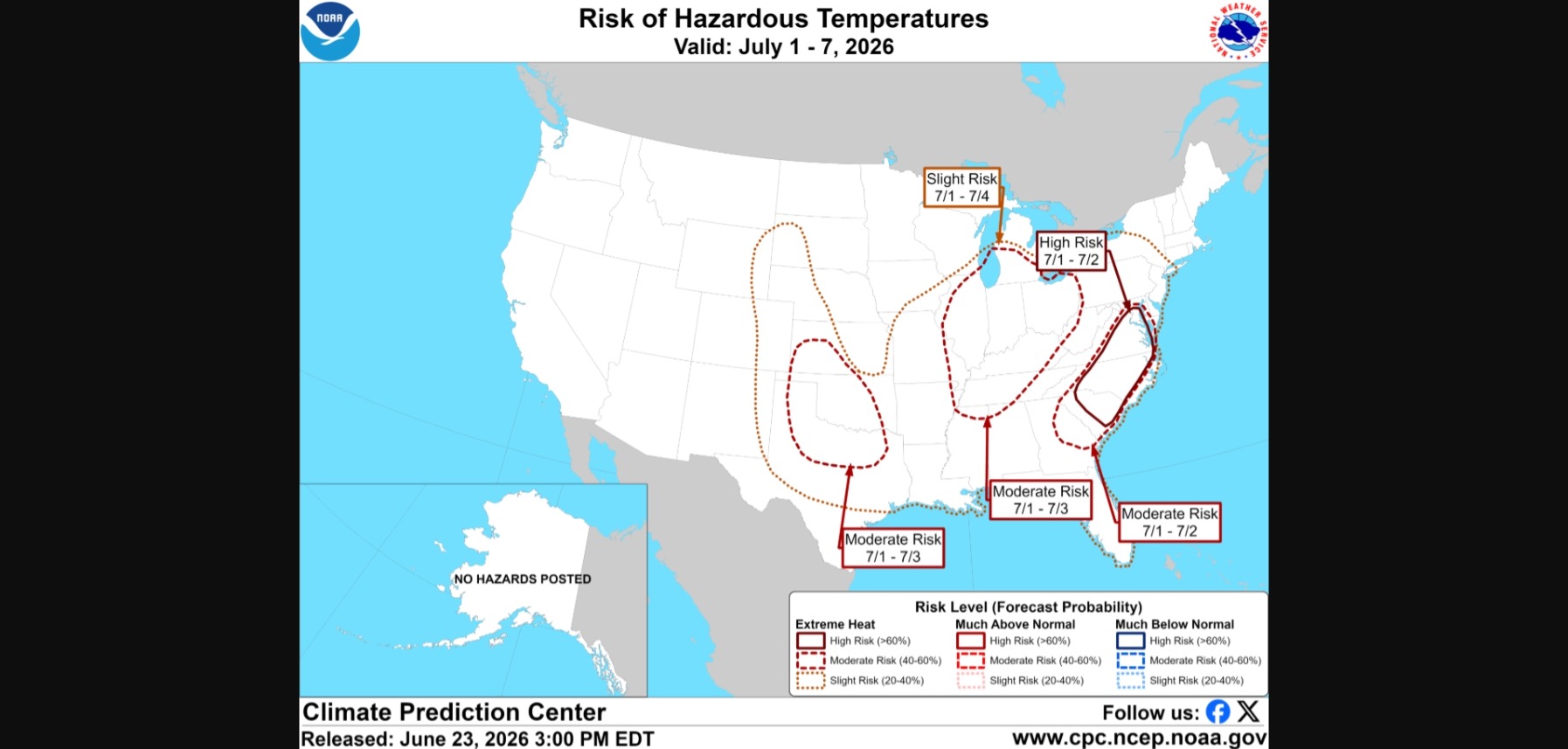
High risk not issued very often this far out.
-
-
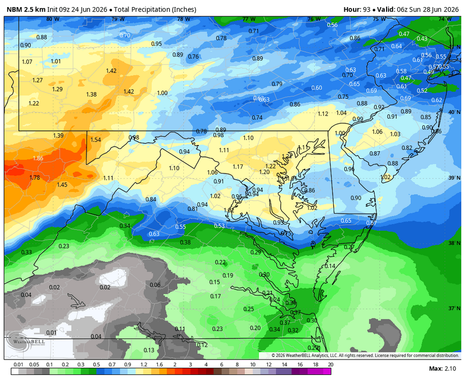
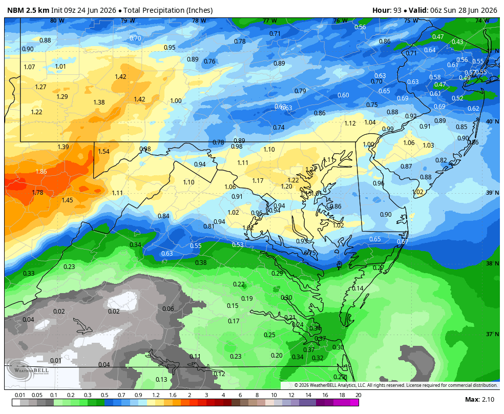
WB 9Z NBM
-
Have an event Saturday morning at the National Zoo. Hoping this is delayed a day.
-
70 / 57 great one on top nicest day of the next 3 with clouds returning Thursday and showers/storms Fri and a cloudy wetter Saturday. By Sunday we dry out and the ridge is building to our west into the Mid West > 594 DM. The period 6/29 - 7/4 overall warm to hot, some tendency for NE / onshore along the shore/beaches with strongest heat inland. With a small pull back then overall warm to hot beyond there in the 7/7 - beyond.
-

2026-2027 Super El Nino
bluewave replied to Stormchaserchuck1's topic in Weather Forecasting and Discussion
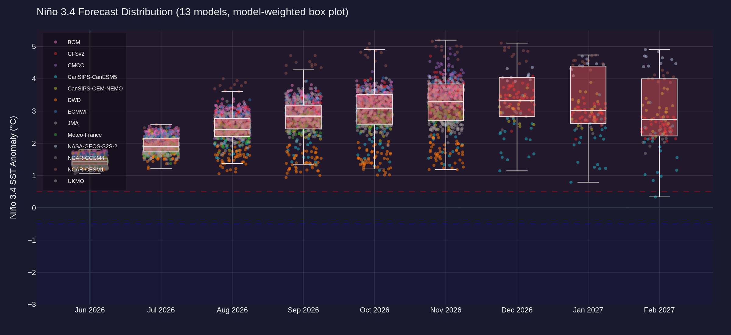
The Euro forecast chart may show what was discussed in that post more clearly.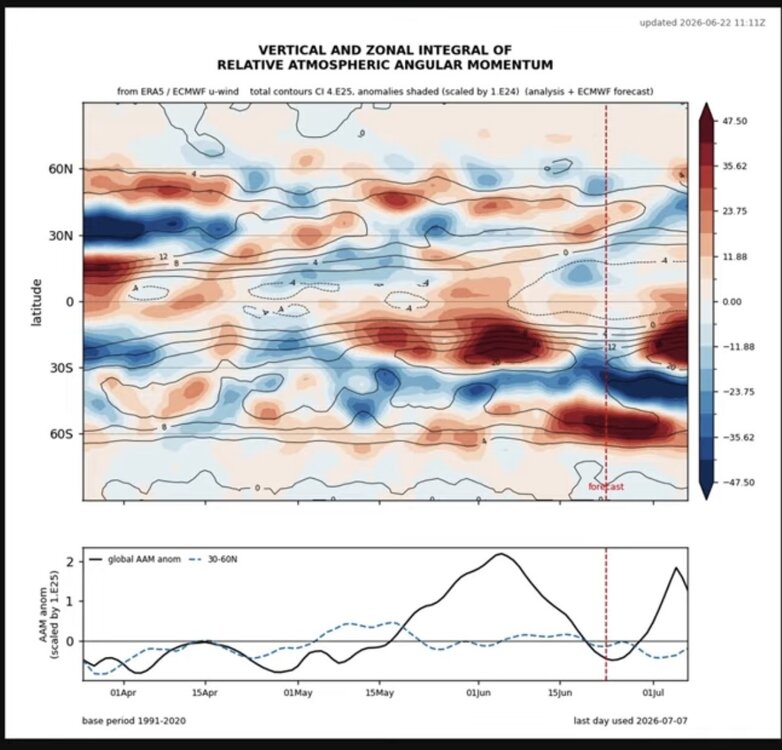
-
wth is this. @OceanStWx
-
We'll see. Yesterday afternoon looked great on paper with LWX highlighting Calvert and St. Mary's for heavy rain potential, and I got a quarter inch. My area has a departure of -8 inches for the year and would need rainfall of 150% to 200% of normal for four straight months to recover.
-
LOL, I think everybody would be happy if it just EXPANDED 75-100 miles to the south. A good 2-3" soaker would do a lot of good for most of us.
-

2026-2027 Super El Nino
olafminesaw replied to Stormchaserchuck1's topic in Weather Forecasting and Discussion
Forecasts have leveled out and holding steady now at +3-+3.5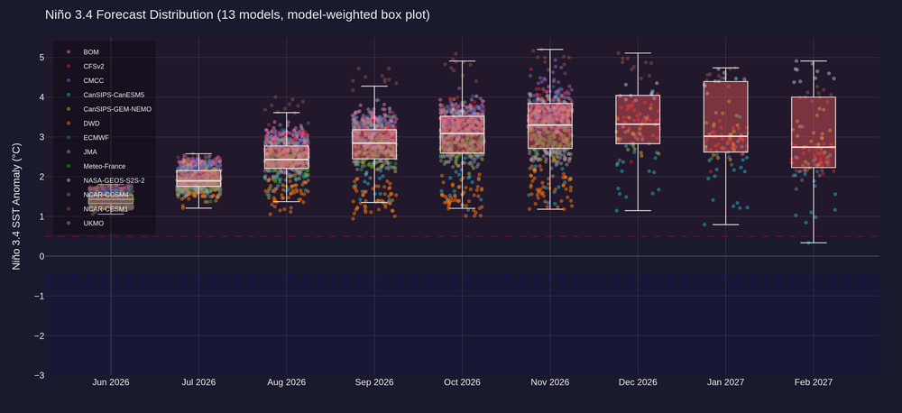
.thumb.png.7cf307fcec61f804a38a245d3d8ff8c3.png)
-
Low of 52.8 here this am with a nice 5 mph N/NW breeze. Refreshing! Low of 34 at Canaan NWR.
-
48.6 felt kind of chilly this morning. Interesting observation: For Augusta, the qp received yesterday was less than half of most expectations from 12 and 18z Monday.
-

2026-2027 Super El Nino
GaWx replied to Stormchaserchuck1's topic in Weather Forecasting and Discussion
The post above from Chris and the one below from Adam are in conflict with Chris’ suggesting more Nina-like (-AAM) and Adam’s stating +GLAAM off the charts! Why are these 2 saying opposites about upcoming AAM? -
That needs to shift south by about a hundred miles
-
Brief mild up.

-
Models begin to build 90° heat to our west as we move into early July. Some models hold onto low pressure just to the east of New England. So they are currently split on whether the 90s make it here or stay to our south.
-
Just over 2” of much needed rain from yesterday.
- Today
-

Junorch obs and discussion 2026
Damage In Tolland replied to Damage In Tolland's topic in New England
What a furnace next week -
Yesterday's rainfall resulted in about a 1 inch rise in Falls Lake water levels. I am guessing it will start dropping again over the next few days.
-
2026-2027 Super El Nino
bluewave replied to Stormchaserchuck1's topic in Weather Forecasting and Discussion
Strongest Southern Hemisphere +AAO since May 2023 as their winter gets underway. The SAM index reached a strongly positive value of +4.23 on June 21, which is a three-year high. That means that mean sea level pressure is currently trending higher than normal near Australia's latitudes, and the westerly wind belt that flows between Australia and Antarctica is located further south than usual for this time of year. This has been evident in the sort of weather we’ve seen lately across southeastern Australia, with fewer cold fronts, frequent blocking high pressure systems, and unseasonably warm temperatures. The last time the SAM index reached 4 (or higher) was in May 2023, when it peaked at 5.5. The values in the index are a measure of standard deviation from the norm in terms of mean sea level pressure. In very basic terms, it means we’ve seen a lot more highs than lows. -

Central PA Summer 2026 Discussion/Obs Thread
mahantango#1 replied to Voyager's topic in Upstate New York/Pennsylvania
-
Central PA Summer 2026 Discussion/Obs Thread
mahantango#1 replied to Voyager's topic in Upstate New York/Pennsylvania
-

Central PA Summer 2026 Discussion/Obs Thread
Superstorm replied to Voyager's topic in Upstate New York/Pennsylvania
57.7F in Lanco with 0.30” of much needed rain. . -
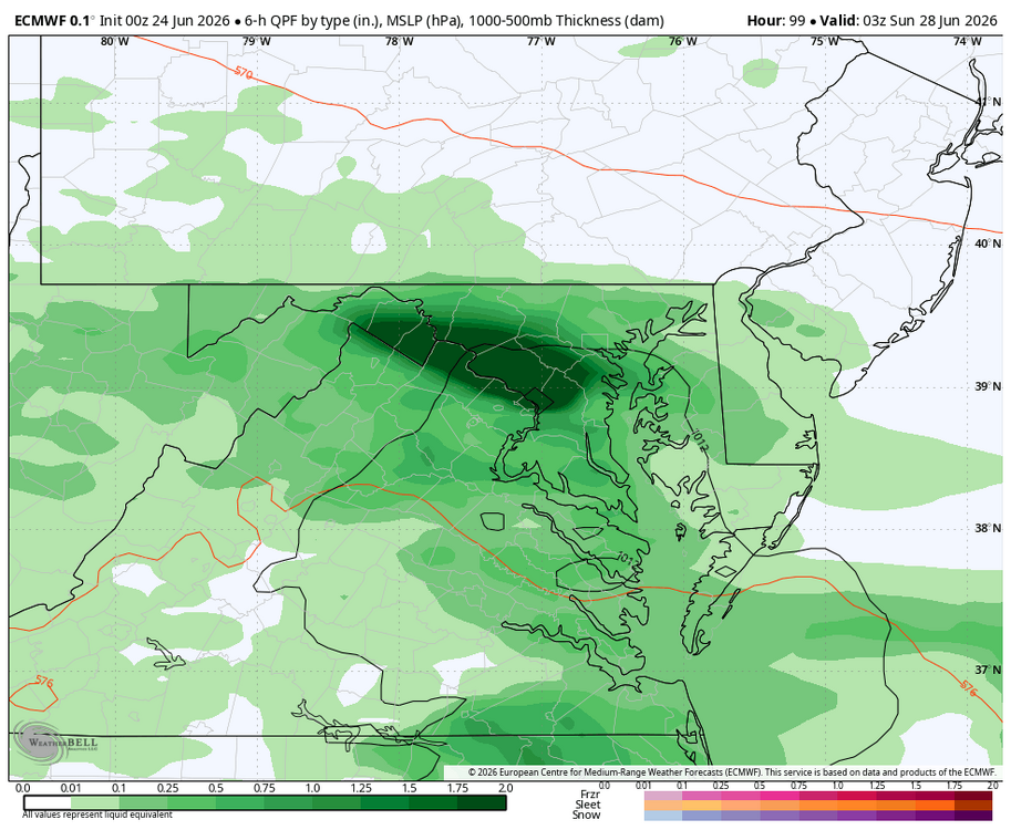
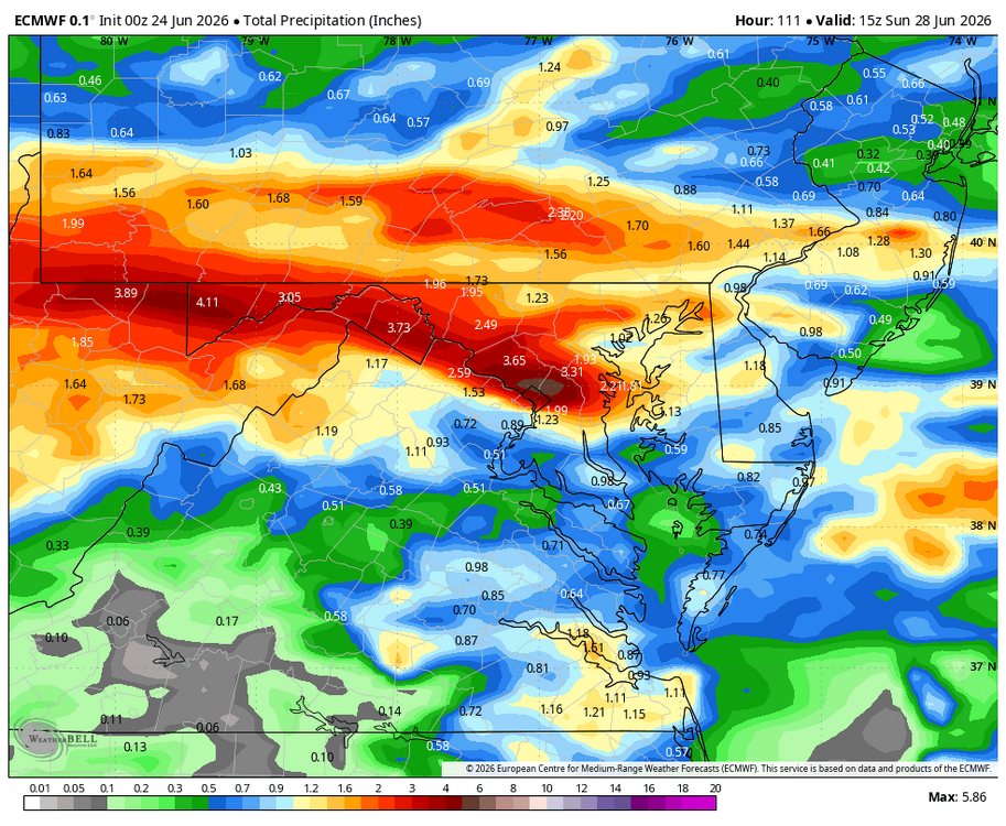
WB 6Z EURO has heavy rain moving through on Saturday.
-
It looks like a front will be stalling over our area late Friday afternoon and low pressure in the Midwest moves along the front and into the area. It looks like a slow mover. It could be a long duration, beneficial rain event. Let's talk about it here.


.png.a448e40cc09f92c0ff34f09adccc35e5.png)


