All Activity
- Past hour
-
560 WTNT42 KNHC 182053 TCDAT2 Tropical Storm Gabrielle Discussion Number 7 NWS National Hurricane Center Miami FL AL072025 Issued by the NWS Weather Prediction Center College Park MD 500 PM AST Thu Sep 18 2025 Gabrielle continues to fight off strong westerly vertical wind shear and significant dry air entrainment this afternoon. Some thunderstorms have blossomed on the storm's eastern flank, which is an improvement from its naked low-level swirl earlier this morning. The initial intensity is held at 45 kt based on recent scatterometer data of at least 40 kt and little in the way of change to its structure from earlier this morning. Atmospheric conditions are expected to remain hostile for another day or so, meaning Gabrielle is likely maintain its current intensity or weaken slightly during that time. Recent 12Z guidance indicates vertical wind shear relaxes and an increasingly moist vertical profile should foster a much improved environment for strengthening this weekend, with the GFS model trending toward the more conducive ECMWF solution. As a result, intensity guidance is notable higher on this cycle. The NHC intensity forecast is raised from the previous one, but not as high as the model consensus mostly due to continuity. There are a growing number of hurricane models that are indicating Gabrielle could approach major hurricane strength after the weekend. Gabrielle is moving west-northwestward at 13 kt and should maintain this track with a bend toward the northwest over the next few days as the storm is steered primarily by a subtropical ridge over the central Atlantic. A turn toward the north and northeast is forecast to occur late this weekend and early next week when Gabrielle rounds the western periphery of the ridge and a frontal system approaches from the west. While the guidance envelope has shrunk on this forecast cycle, there are some significant speed differences, with the ECMWF/GFS models considerably faster than the Google Deep Mind ensemble. Although no significant changes to the forecast were made, confidence remains on the lower side given the along-track model spread and an unclear intensity forecast beyond 48 hours. Interests in Bermuda should continue to monitor Gabrielle over the next several days. FORECAST POSITIONS AND MAX WINDS INIT 18/2100Z 20.8N 52.7W 45 KT 50 MPH 12H 19/0600Z 21.5N 54.2W 40 KT 45 MPH 24H 19/1800Z 22.6N 56.3W 40 KT 45 MPH 36H 20/0600Z 23.9N 58.1W 45 KT 50 MPH 48H 20/1800Z 25.3N 59.8W 50 KT 60 MPH 60H 21/0600Z 27.1N 61.1W 55 KT 65 MPH 72H 21/1800Z 29.0N 62.0W 65 KT 75 MPH 96H 22/1800Z 33.0N 61.0W 85 KT 100 MPH 120H 23/1800Z 39.0N 52.5W 80 KT 90 MPH
-

September 2025 OBS-Discussion centered NYC subforum
Stormlover74 replied to wdrag's topic in New York City Metro
And even this weekend will be at or just below average. -
Hit a high of 92 today, with a low of 67. 92 in September feels a lot different than 92 in August. More heat for us in southern ATL area. Great time of year! Pool in the afternoon, and football/MLB out back when the sun goes down. Loviing life down here in the South, well other than the lack of rain in the summer. Don't miss NY weather at all
-

September 2025 OBS-Discussion centered NYC subforum
winterwx21 replied to wdrag's topic in New York City Metro
84 degrees here right now. Mid 80s again tomorrow, and I think we'll see mid 80s again on Tuesday. Still some nice warm summery days ahead. -
The hundredth shy is just Stein slapping you right in the face. Brutal.
- Today
-
In W MA it’s a 30 minute drive from normal to moderate drought. Crazy gradient with regards to rainfall the past month or so.
-

September 2025 OBS-Discussion centered NYC subforum
bluewave replied to wdrag's topic in New York City Metro
Will be intersting to see if Walpack, NJ actually has a colder August monthly minimum temperature than September. They made it down to 37° on 8-31. The lowest so far this month has been 38°. After some cooler temperatures this weekend the pattern warms up again next week. Walpack NJ 2025-08-31 Mesonet 79 37 Walpack NJ 2025-09-09 Mesonet 75 38 -
2.1" here. +1
-
In most cases I wouldn't even think twice about the Euro AI showing a system developing in the Western Carribean at Day 11, but it is interesting to note that both the Google Deep Mind GenCast and regular Google Deep Mind ensemble are highlighting TC genesis in the same location and time, and then tracking into the Gulf. What are the AI models picking up on (or not) that the physics-based deterministic aren't? And to note, even the NHC is using the Google DM in their official forecasts. It has done very well this season.
-

2025 Atlantic Hurricane Season
Silver Meteor replied to BarryStantonGBP's topic in Tropical Headquarters
Locally (Greenville, N.C.) it's been a strange summer too. With 22 days of below normal temps the high for August was a mere 91F. If not for that long stretch of brutal humidity in the first half of the month it would have been perfectly enjoyable. September so far has been remarkably cool and better yet, no problems with humidity. Our summer "died" much like the hurricane season. -
lol, Nope.
-
fixed it
-
81.1° What a day
-
OH, well yeah... We're actually saying the same thing. I suspect it takes like a +3 sigma warm ENSO to finally tastes more than pepperRONIs enough to finally flavor the pizza of winters. haha... sorry about the dad joke. By the way ... you and I first started speaking ( in concept ) about RONI back in like 2009 - not sure you recall but that science isn't very novel at least to me. In fact, I remember back in 2004 having a discussion similar to compression/speed surplus with a fellow college alum. Anyway, point really being that I think when concepts emerge in multiple realms and are the same, that tends to be closer ( at least 'closer' ) to universally useful. Kinda of like fire was discovered all over the world at the same time 10s of thousands of years faster than word could have traveled about how to control it.
-
September 2025 OBS-Discussion centered NYC subforum
Stormlover74 replied to wdrag's topic in New York City Metro
Ewr 86. Lots of mid 80s showing up -

September 2025 OBS-Discussion centered NYC subforum
Krs4Lfe replied to wdrag's topic in New York City Metro
I don't post here often, mainly only during wintertime. But this post resonates. I feel that the 2000s and 2010s being record snowy was the final push before our winters became too warm to support above average snowfall. We had the right amount of cold air and moisture, the right balance, to allow for those amazing winters. But this decade, we've been in bad spots all around except 2021 and 2022 (for some posters.) And it doesn't seem to be getting any better either. Maybe one day we'll see a good winter again. -

2025-2026 Fall/Winter Mountain Thread
Maggie Valley Steve replied to Buckethead's topic in Southeastern States
I headed up to Waterrock Knob today to check out the leaf progression. There is some change with a few trees beginning to show changes towards vibrant reds, orange and yellow. We're probably about 10 to 15 days away from peak at elevation. Surprisingly around the house, Poplar are turning yellow and brown and beginning to fall. That late August cold spell did it's work! -
Yeah, too hot.
-
-
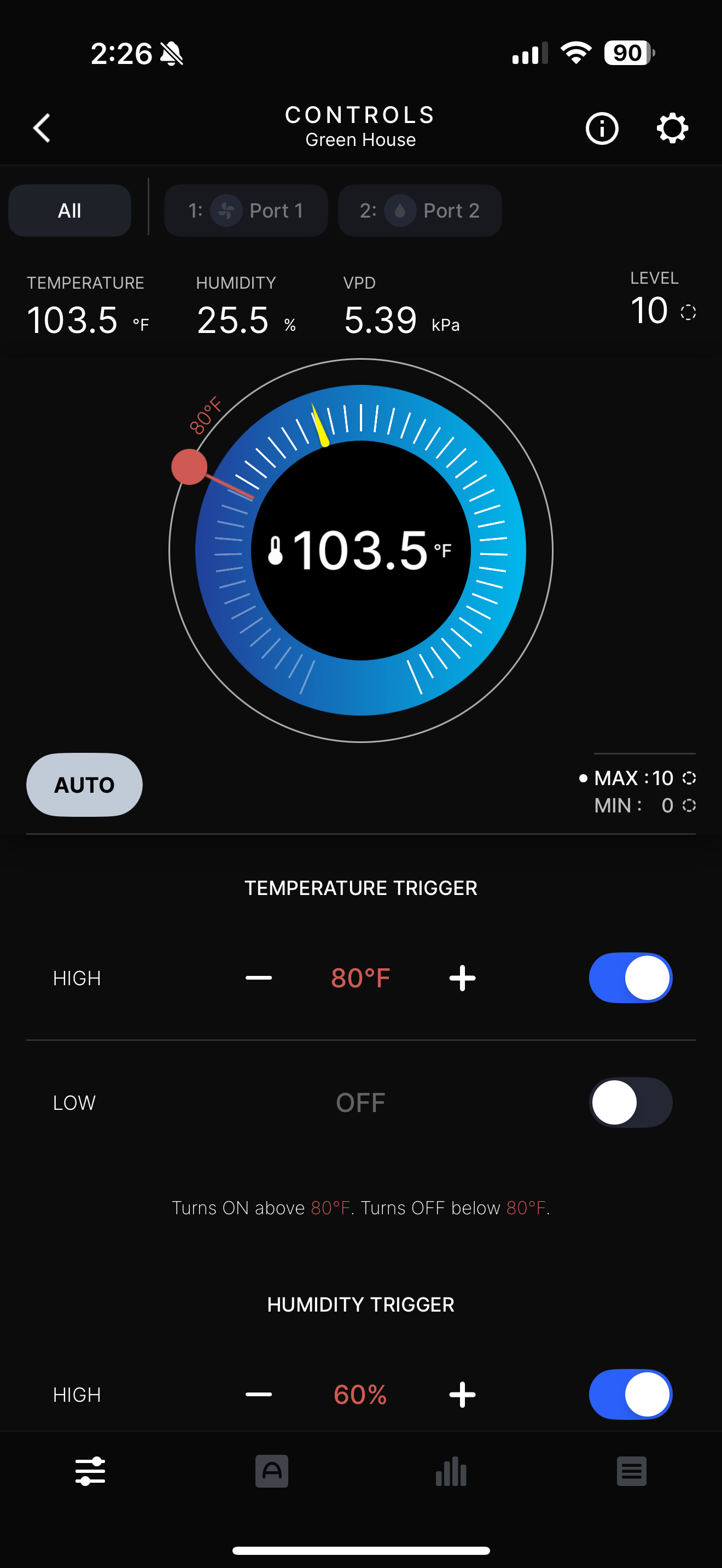
Ha ha, Yes, Going to use passive heat to heat this winter too, Let the sun do the work, Quite warm in there today.
-
0.99”
-
Those are some pretty low probs for MSS (massena) and EFK (newport) given the guidance.
-
Looks great! U fancy. I have the frame from an old trampoline and some plastic.
-

E PA/NJ/DE Autumn 2025 Obs/Discussion
MGorse replied to PhiEaglesfan712's topic in Philadelphia Region
A total of 0.26" of rain yesterday. Better than 0.00" -


.thumb.png.4150b06c63a21f61052e47a612bf1818.png)