All Activity
- Past hour
-

Possible Record Breaking Cold + Snow Sunday 1/25 - Tuesday 1/27
SACRUS replied to TriPol's topic in New York City Metro
Snow starts to arrive betwen 3am - 8am Sunday -

Possible Record Breaking Cold + Snow Sunday 1/25 - Tuesday 1/27
hooralph replied to TriPol's topic in New York City Metro
This is why PBP are so awful. -
I know the EURO is the EURO but it’s only model not East Tennessee Ice which I’m hoping for, but seems like the outlier at this point. .
-
First flakes out here around 6 on Saturday. Over the Blue Ridge by 7.
-

Possible Record Breaking Cold + Snow Sunday 1/25 - Tuesday 1/27
psv88 replied to TriPol's topic in New York City Metro
Euro is Weast -
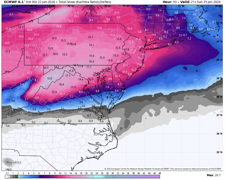
Waiting for final but DC over a foot.
-
After the mix, not including possible back end, mix line shifted SE about 5 miles
-

Possible Record Breaking Cold + Snow Sunday 1/25 - Tuesday 1/27
Franklin0529 replied to TriPol's topic in New York City Metro
The euro AI is a foot Plus region wide -
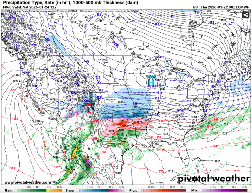
Having the subtropical jet throwing moisture straight at a 1045 HP in southern Wisconsin and ending up with 0 inches of snow in the valley is like the weather equivalent of throwing a pick six on 1st and goal from the 1... we're just sitting there watching the warm nose run it back for a touchdown. The HP actually retreating northwest between hours 60 and 66 is a nice touch, like the QB chasing down the warm nose and giving up, lol
-
12” in DC on the Kuchera
-
That’s a lot of juicy IPA. I mean QPF. lol. Waiting on @NorthArlington101 clown maps
-
I hadn't looked at the GFS. It still managed to give me 10 inches. I'm 1000 percent sure it's wrong, but I'd be overjoyed with that.
-

Possible Record Breaking Cold + Snow Sunday 1/25 - Tuesday 1/27
Snowlover11 replied to TriPol's topic in New York City Metro
Lmao -

Possible Record Breaking Cold + Snow Sunday 1/25 - Tuesday 1/27
KeithB replied to TriPol's topic in New York City Metro
It's funny....I was supposed to be up at Stowe this weekend, and due to some work stuff, I had to move it out 2 more weeks. Last 48 hours I have been THRILLED thinking thank god I am not up there and am here!....would be some kick in the ass if we get sleeted and they wind up getting the 18+. Vermont snow totals, all the way up to and past Stowe, are rising on ever model run -
Euro is beginning to give me “what storm” vibes. .
-
Let’s see it
-
Let's say 85% of that is snow at DCA... woof
-
Yeah. Talking to him on text.
-
0z Euro gonna be better I think
-

Possible Record Breaking Cold + Snow Sunday 1/25 - Tuesday 1/27
eduggs replied to TriPol's topic in New York City Metro
Euro looks wet and warm. No major reversal to the north/amped trend but still a major event. -
And that looks like a horrific icestorm for the Richmond area.
-
Zwyts? where is he?
-
Man that is juiced up. We are gonna have glaciers for weeks.
-

“Cory’s in LA! Let’s MECS!” Jan. 24-26 Disco
WxWatcher007 replied to TheSnowman's topic in New England
The geographic scale of this storm is just so impressive. Euro should cook. -
I am not set on a huge ZR for this area yet... but I am losing the battle against hope. That withstanding, if the CAD is going to hold on so strongly, perhaps the Mid Levels stay just cold enough to keep us as sleet over ZR. That or perhaps the CAD is enough to shunt the storm a bit futher South.