All Activity
- Past hour
-
22 here as well; back to back cold nights.
-
34 here
-
18F here again. Big warmup incoming though.
-

Central PA Spring 2026 Discussion/Obs Thread
Voyager replied to Voyager's topic in Upstate New York/Pennsylvania
Not sure what happened, but CTP made a major correction overnight. Maybe mahantango's exorcism gif did the trick... Wednesday Night Showers likely and possibly a thunderstorm. Mostly cloudy, with a low around 44. Chance of precipitation is 60%. Thursday A chance of showers. Mostly cloudy, with a high near 55. Chance of precipitation is 50%. Thursday Night Showers likely. Mostly cloudy, with a low around 40. Chance of precipitation is 60%. Friday Showers likely. Cloudy, with a high near 56. Chance of precipitation is 60%. Friday Night Showers likely. Cloudy, with a low around 46. Chance of precipitation is 60%. Saturday A chance of showers. Cloudy, with a high near 61. Chance of precipitation is 50%. -
28 imby w/frost.
-
Central PA Spring 2026 Discussion/Obs Thread
Voyager replied to Voyager's topic in Upstate New York/Pennsylvania
It wasn't the freezing rain that got me, but the cold air and chance of frozen precipitation falling. I'm pretty sure the snow (hopefully anyway) wouldn't accumulate either. I'm not saying I want 75 every day going forward, I'm just sick of the cloudy 40's, and wish we'd not drop below 50 on the cooler days. -
Eff this. 22-23F.
-
22 here this morning.
-

Central PA Spring 2026 Discussion/Obs Thread
mahantango#1 replied to Voyager's topic in Upstate New York/Pennsylvania
Wxrisk.com This current cold shot is probably the last REAL cold blast until late autumn. Now for the obtuse people in the back row you need to read that first sentence again carefully. yes of course between now and June 1 we are going to have cold fronts and cold or cool air masses. Obviously that is the case. What I am talking about in the first sentence are these cold blasts which knock us back down to the 20s at night and 40s to near 50 during the day. . All the data shows there is going to be a significant Ridge in the jet stream (sometimes extremely strong Ridge) that will be situated on the East Coast covering the eastern third of the country between now and April 15th. Any cold wants to come through will be weak and have no will push behind them. THAT BEING SAID REMEMBER SOIL TEMPS STILL HAVE TO WARM !! The old guideline zof waiting until aat least EASTER and preferably tax day...s till holds. -
Central PA Spring 2026 Discussion/Obs Thread
mahantango#1 replied to Voyager's topic in Upstate New York/Pennsylvania
-
18.4° Hopefully this is the last morning of sub 25° temps.
- Today
-
Looks like its coming. From WTNH New Haven. As we head into the final days of March, a big warm-up is on the way. Highs climb into the low 60s Monday, near 70 Tuesday, and widespread 70s by Wednesday. A few inland spots could even approach 80°, depending on the timing of an approaching cold front. This is record-challenging warmth, so we’ll be keeping an eye on both Windsor Locks and Bridgeport, where official records are kept for inland and shoreline locations.
-
Down to 18F in the valley in E CT; need some warm weather.
-
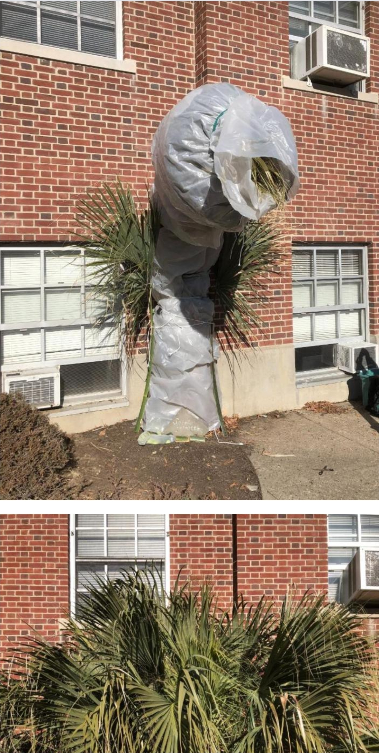
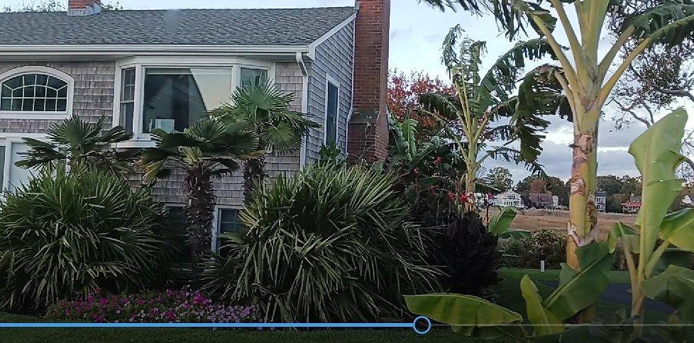
This is from the guy who planted the Sabal Palm in Bridgeport which is supposedly the northern most palm tree actively growing. Looks like it survived this winter just fine. i planted this palm outside in 2009 after much research on the microclimate of that spot the bricks hold so much heat in the winter i would often see flies overwintering there in February it’s very close to Long Island sound the alcove blocks the north wind minuses Dr Franco’s mummy wrap from his book Palms won’t grow here and other myths and I think you’re right about the building leaking heat as 1.5 feet away from the foundation never freezes plus I think for years folks never really knew how resilient Sabal palmettos actually are there are examples of these bosoms growing in Tennessee zone 6 for years and years so i just took a chance we are plannng on opening up Sabal palmetto Bridgeport WED April 8th,2026 after the cold weather passes; what a winter 2025-2026

-
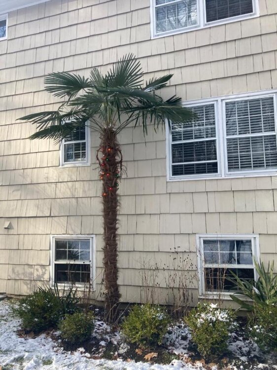
All the old Italian guys are growing figs all along the shoreline here. Haha What's more interesting is the palms people are growing here. They apparently use C9 Christmas light incandescent bulbs to keep them warm over the winter. This is a picture fom a house in Norwalk, CT on the shoreline and one in Stamford.
-
So far at about 0430, the lows so far: DCA 36 IAD 27 BWI 27
-
 Yeah I did not mention lows as we are all on the same page. There are some great ways to mitigate urban heat islands that are sadly underutilized. Green roofs, painting asphalt white and mitigation of suburban sprawl. Regardless of the UHI influence (which is hard to quantify) it’s a historic and unprecedented run. .
 -
 We’ve talked about UHI being a nontrivial portion of Phoenix’s warming. I’ve brought it up, myself. But, note as you may already realize that the UHI affects the warming of lows more than the warming of highs (assuming I’m not mistaken).
 -
RIP Roger. So sad.
-

Central PA Spring 2026 Discussion/Obs Thread
canderson replied to Voyager's topic in Upstate New York/Pennsylvania
It’ll be close to 20 degrees above normal Monday through Wednesday. Freezing rain at 45? No way. -
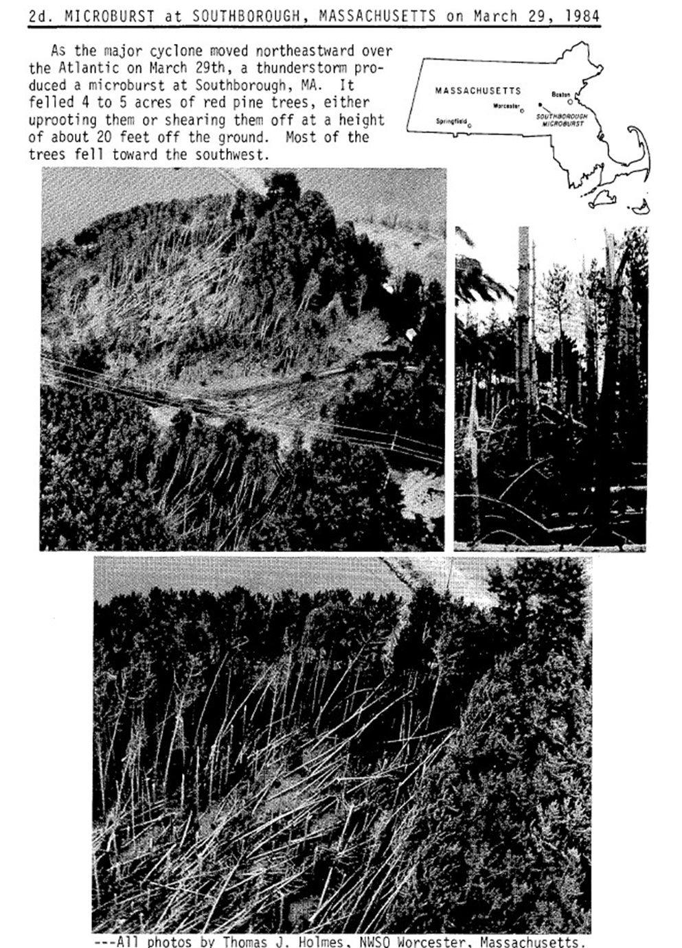
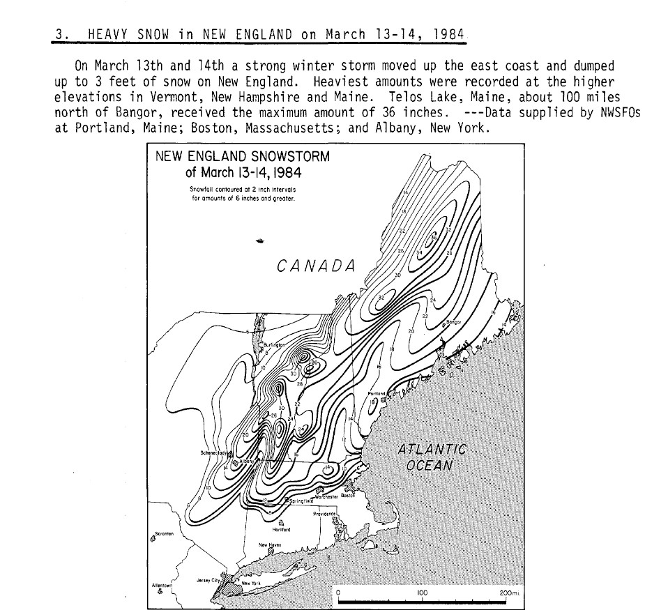
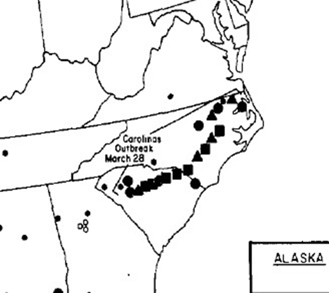
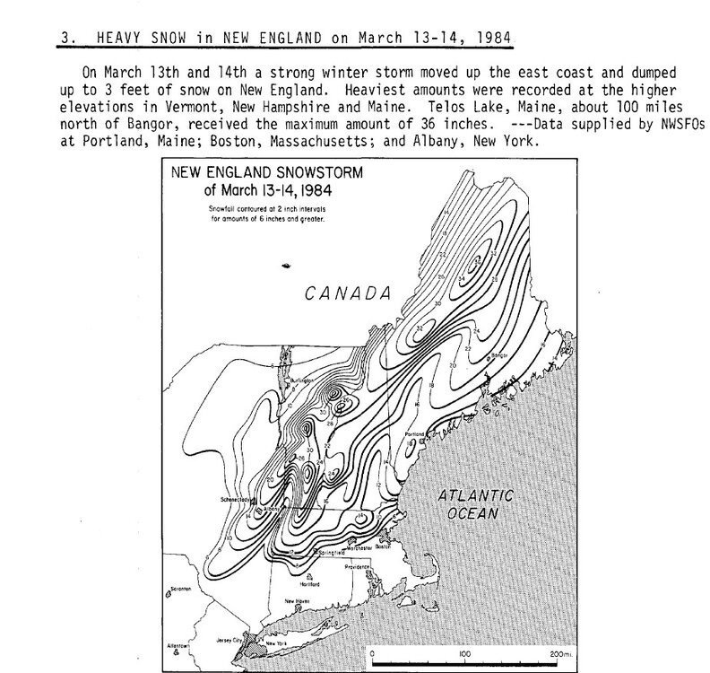
42 years ago today, one of the nastiest March blizzards occurred. Actually it was a 3 day event for the country. Storm (all STJ-driven) set pressure records for the month from the Desert SW to the SEUS/Mid-Atlantic. On 3/27 ahead of the low, Cotulla TX hit 108 F for to tie the highest temp in March for the U.S. (first set in 1954). Brownsville hit 106 F for not only its all-time record high March temp, but also all-time for any month. On 3/28, the worst tor outbreak for NC/SC occurred (57 fatalities). A single supercell long-tracked supercell produced 7 F4 tors, the most violent tors from a single storm, and it acted a lot like the Tri-State Tor from March 1925. Supercell was very close to the synoptic-scale low pressure that was sub-980 mb - that's really deep over land that far S. This storm produced 16 tors total w/ 3 F2 and 3 F3. The 13 F2+ tors I think is record for most F2+ tors from a single storm. One tor in SC was 2.5 mi wide at one point, which was the record width until 2013. On 3/29, the sfc low deepened to 963 mb E of the Delmarva and produced a blizzard (paste bomb) in New England w/ among the largest power outages/ worst tree damage on record for a winter storm for southern New England (worst power outage for MA since the 1965 E Coast blackout). 17" at ORH. MQE gusted to 108 mph, its highest gust since Donna in 1960 and nothing has matched that since. TS+ was widespread and legit microburst occurred in Southborough MA during the blizzard, flattening an area of trees. How crazy is that? I know of no other documented case like this. I recall it well. Doing my paper route that morning, it was the first time I saw a morning rainbow (not your typical pre-snowstorm sky, very convective-looking). Rain starting almost immediately turned to snow while on my route. Of course, school was not cancelled and the didn't even send us home early, despite blizzard conditions by late morning. March 1984 had a another biggie for interior sections mid-month w/ CAR getting 28.6" in 24 hr, by far it greatest 24 hr total on record. I attached a snowfall map. Something about those hand-drawn snowfall count maps that look so cool!

-
Hey @Stormchaserchuck1any thoughts about this? Fairbanks is progged to have its coldest DJFM on record with it ~-13.1F! The current coldest DJFM: 1965-6: -12.9F El Niño 1970-1: -11.6F La Niña 1933-4: -11.1F La Niña 1917-8: -10.6F La Niña By a margin of 2F, they’re progged to have their coldest March on record at ~-8.6F! Link to data that allowed me to calculate this out: https://www.weather.gov/wrh/Climate?wfo=afg
-
They forecast based on population weighted because their forecasts are for the purpose of forecasting AC usage as opposed to what you look at, which isn’t pop weighted. Does that relate to your post?
-
Followup: Fairbanks is progged to have its coldest DJFM on record with it ~-13.1F! The current coldest DJFM: 1965-6: -12.9F El Niño 1970-1: -11.6F La Niña 1933-4: -11.1F La Niña 1917-8: -10.6F La Niña By a margin of 2F, they’re progged to have their coldest March on record at ~-8.6F! This feat is extra amazing because the Arctic has warmed the most due to GW! Link to data that allowed me to calculate this out: https://www.weather.gov/wrh/Climate?wfo=afg
-
We grow them in Connecticut. You just want to wrap them up in the winter time to protect them