All Activity
- Past hour
-

September 2025 OBS-Discussion centered NYC subforum
LibertyBell replied to wdrag's topic in New York City Metro
1989 - Seventeen cities in the north central U.S. reported record low temperatures for the date, including Devils Lake ND with a reading of 22 degrees. Jackson KY reported a record low of 41 degrees during the late afternoon. Strong northwesterly winds ushering cold air into the central and northeastern U.S. gusted to 55 mph at Indianapolis IND. Winds along the cold front gusted to 65 mph at Norfolk VA, and thunderstorms along the cold front deluged Roseland NJ with 2.25 inches of rain in one hour. The temperature at Richmond VA plunged from 84 degrees to 54 degrees in two hours. Snow and sleet was reported at Binghamton NY. (Storm Data) (The National Weather Summary) wow was this the earliest ever occurrence of snow at Binghamton? 1989-1990 was such a weird time, we had historic nationwide severe wx outbreaks in September, October and November (that last one killed 10 kids at Coldenham HS in Westchester) and early extreme cold that lasted through December with a freak snowstorm just before Thanksgiving too. And then spring arrived just in time for New Years and it was consistently warm through March until winter gave us a last blast of snow in early April lol. -
Yeah you are in a different climate down there. These early season cold fronts sometimes get hung up just north of you.
-
Finally had a good drink yesterday... 1.6" of rain IMBY. Looks like CLE missed most of the rain. Not sure it is going to be a good foliage season... the colors seem muted with rapid leaf drop.
-
Used to get a deer feeding on my dogwood at the old house. Please rain, my lawns crying for moisture.
-
Unfortunately still very dry for most of GA. Really hoping the cold front moving through Thurs/Fri gives us some beneficial rain.
-
September 2025 OBS-Discussion centered NYC subforum
LibertyBell replied to wdrag's topic in New York City Metro
1815 - One of the greatest hurricanes to strike New England made landfall at Long Island and crossed Massachusetts and New Hampshire. It was the worst tempest in nearly two hundred years, equal to the hurricane which struck in 1938, and one of a series of severe summer and autumn storms to affect shipping lanes that year. (David Ludlum) I'm always fascinated by these old historic storms, what was its path and was this a Cat 3 at landfall, Tony? a 20-30 foot surge too? Two big hurricanes made landfall on Long Island in the early 1800s, in 1804 and 1815. The one in 1804 was the famous snowicane. -
Flowering dogwood consistently produces small fruit that wildlife loves. A cloudy morning - quite unusual in recent months. No rain, but maybe tonight.
-
I actually "liked" that, but then realized central NH and Maine need it way more than we do here. I looked at HPC QPf for over the next five days, and it does indeed look like all, pretty much(?) New England gets a good dousing.
-
September 2025 OBS-Discussion centered NYC subforum
LibertyBell replied to wdrag's topic in New York City Metro
Thats why it's so great to see the sun come out and now it's bright and sunny with deep blue skies -
September 2025 OBS-Discussion centered NYC subforum
LibertyBell replied to wdrag's topic in New York City Metro
we won't -
September 2025 OBS-Discussion centered NYC subforum
LibertyBell replied to wdrag's topic in New York City Metro
I definitely do not miss that time, high winds -40 to -60 windchills and icy sidewalks that were so slippery, this was my experience in the mid to late 1980s. -
September 2025 OBS-Discussion centered NYC subforum
LibertyBell replied to wdrag's topic in New York City Metro
that happened during the 80s too and icy sidewalks YUCK -

Fall 2025 Medium/Long Range Discussion
A-L-E-K replied to Chicago Storm's topic in Lakes/Ohio Valley
WAD winter incoming? -

Fall 2025 Medium/Long Range Discussion
OrdIowPitMsp replied to Chicago Storm's topic in Lakes/Ohio Valley
Extended looks warm and dry. We’ll probably continue with highs in the 70s until the inevitable sharp cold front and first flakes around October 18-20th. Seems to happen like that almost every year around here. -

September 2025 OBS-Discussion centered NYC subforum
wdrag replied to wdrag's topic in New York City Metro
for now-no thread on the oncoming early Tuesday morning WPC D1-3 1-3" and SPC D1 and D3 marginal svr. Anything after Friday morning is in doubt. Think it best to happen in the 60 hr window 18z today-06z Fri. -
Just waiting for penn state to get embarrassed at home next week against Oregon for the trifecta of disappointing high expectation sports teams in 2025 to be complete
-

Pittsburgh PA Fall 2025 Thread
PghPirates27 replied to TheClimateChanger's topic in Upstate New York/Pennsylvania
1.98" of much needed rain yesterday here. -
7 times
-
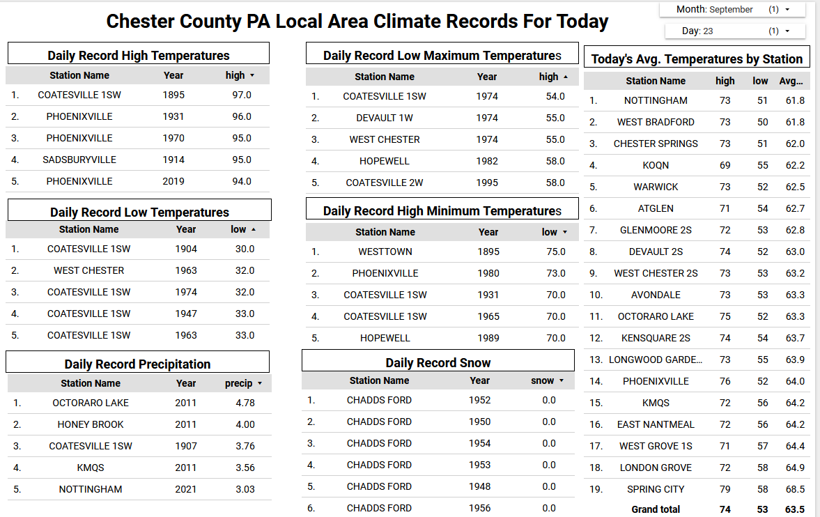
The NWS continues to forecast between 1.5" to 2.0" of rain across much of the area by Friday morning. Western areas of Chester County could see some beneficial rain starting this evening...further east chances look to be less. Rain chances really increase by late Wednesday night through Thursday. With the rain it will be relatively warm and humid for late September with little range in temperatures from PM highs to AM lows mainly in the mid to upper 70's for highs and the low to mid 60's for low temperatures. We start to dry out a bit on Friday before we clear out and turn cooler by Sunday.

-
Husky stadium is beautiful and loud. Washington should have a decent team next year so maybe you'll get a fun night game to attend with huge playoff implications since it is the final game of the season. My dad and brother went out to the USC game last year and loved it. Regardless, that seems like a wonderful boys trip. Sent from my SM-G970U1 using Tapatalk
-
(002).thumb.png.6e3d9d46bca5fe41aab7a74871dd8af8.png)
E PA/NJ/DE Autumn 2025 Obs/Discussion
ChescoWx replied to PhiEaglesfan712's topic in Philadelphia Region
The NWS continues to forecast between 1.5" to 2.0" of rain across much of the area by Friday morning. Western areas of Chester County could see some beneficial rain starting this evening...further east chances look to be less. Rain chances really increase by late Wednesday night through Thursday. With the rain it will be relatively warm and humid for late September with little range in temperatures from PM highs to AM lows mainly in the mid to upper 70's for highs and the low to mid 60's for low temperatures. We start to dry out a bit on Friday before we clear out and turn cooler by Sunday.
-
While there’s still a lot to sort out, if 94L doesn’t merge with 93L as the GFS tries to predict, it very well may be an east coast threat. This is worth a close watch.
-
She ain’t done yet baby..soak it in and let the moisture flow later today!
-
 The Euro trend has been toward a more robust system, with 06z showing a strong storm. What’s far more important however for a D6 forecast is the Euro continues to show a cutoff low over the southeast with a ridge building over the top of the eastern U.S., effectively guaranteeing a bona fide east coast threat. Here, it looks like the trough to the east (top right of image) is not enough to kick this out to sea. AI models in general support this upper level configuration too. Now, before coastal folks get too concerned, there’s still a LOT to sort out because while the cutoff looks legit, we don’t know where it’ll be, the location of the ridge, and how much, if any, an escape window opens. There’s also the big question of how the spacing of the three systems—Gabrielle, 93L, and 94L, impact track and intensity of 94L. Now that this is an invest, the additional resources will help us nail this down. This one is worth more than a casual eye.
 - Today
-

September 2025 OBS-Discussion centered NYC subforum
SACRUS replied to wdrag's topic in New York City Metro
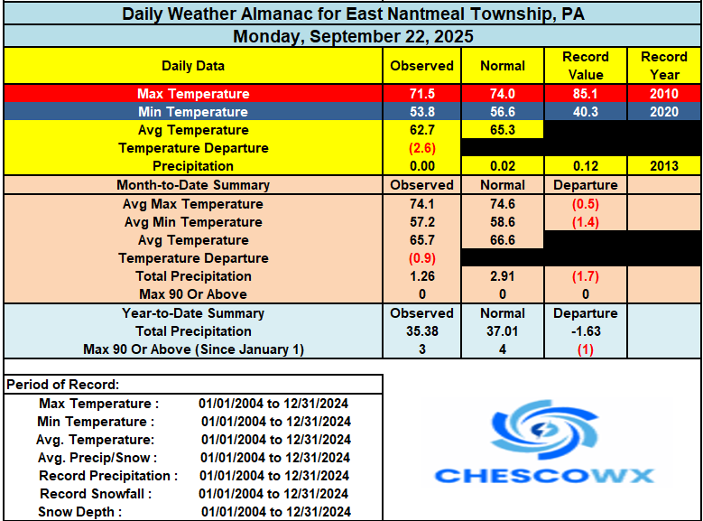
Records: Highs: EWR: 94 (1970) NYC: 97 (1895) LGA: 93 (1970) JFK: 90 (1970) Lows: EWR: 40 (1947) NYC: 41 (1947) LGA: 42 (1947) JFK: 43 (1963) Historical: 1722: La Nouvelle-Orléans (New Orleans) was founded May 7, 1718, by the French Mississippi Company, under the direction of Jean-Baptiste Le Moyne de Bienville, on land inhabited by the Chitimacha. Four years later, a hurricane destroys nearly every building in the village, including the only church and hospital. 1785: The "most tremendous gale of wind known in this country" passed over the Lower Chesapeake Bay and went along a track very similar to the Chesapeake-Potomac Hurricane of 1933. At Norfolk, lower stories of dwellings were flooded. Warehouses were totally carried away by the storm surge, causing large amounts of salt, sugar, corn, and lumber to disappear. A large number of cattle drowned, and people hung onto trees for dear life during the tempest. At Portsmouth, the entire town was submerged. Forrest's book, Sketches of Norfolk, offers this account of the storm: " This year, 1785, was noted for the highest tide ever before known to Norfolk, completely deluging a large portion of its site on the water side". Almost all ships in the area were driven from their moorings near Norfolk. No less than 30 vessels were seen beached after the storm. Damages totaled £30,000. At least two died due to shipping disasters. After ravaging Virginia, the system tracked up the coast to Boston. (Ref. Hurricane of 1785) 1815 - One of the greatest hurricanes to strike New England made landfall at Long Island and crossed Massachusetts and New Hampshire. It was the worst tempest in nearly two hundred years, equal to the hurricane which struck in 1938, and one of a series of severe summer and autumn storms to affect shipping lanes that year. (David Ludlum) 1903: Bakersfield, CA dropped to 31°, their earliest below freezing temperature. (Ref. Wilson Wx. History) 1904 - The temperature at Charlotteburg, NJ, dipped to 23 degrees, the coldest reading of record for so early in the autumn for the state. (The Weather Channel) 1937: From summer to winter. The temperature was 101 at Wheaton. Then a cold front came through causing the mercury to tumble below freezing. (Ref. AccWeather Weather History) 1975: On September 22, Hurricane Eloise intensified to attain Category 2 strength, and became a major hurricane of Category 3 status shortly after that as it turned towards the northeast. Several ships penetrated the storm's center during its passage through the Gulf. Hurricane Eloise continued to strengthen until it reached its peak winds of 125 mph and a minimum barometric pressure of about 955 mbar. It moved ashore along the Florida Panhandle near Panama City on September 23. 1983 - A thunderstorm downburst caused a timber blowdown in the Kaibab National Forest north of the Grand Canyon. Two hundred acres were completely destroyed, and scattered destruction occurred across another 3300 acres. Many trees were snapped off 15 to 30 feet above ground level. (The Weather Channel) 1984: An early season snowstorm brought more than a foot of snow to some locations in the northern Plains and Rockies. Amounts of 6 to 12 inches were common over Harding and Perkins Counties as well as portions of Meade and Butte Counties in South Dakota. Camp Crook in Harding County reported 14 inches. Roads in these areas were covered with snow and slush and became icy. It was the snowiest September day on record at Sheridan, WY and Billings, MT with 12.9 inches and 6.2 inches respectively. Other snowfall totals included: Broadus, MT: 12 inches, Columbus, MT: 10 inches, Nye, MT: 10 inches, Clearmont, MT: 10 inches, Hysham, MT: 8 inches, Red Lodge, MT: 7 inches. (Ref. Wilson Wx. History) 1985: Early snow over portions of Minnesota and western Wisconsin. Just under a half inch (.4) recorded at the Twin City Airport. Most of it fell during the afternoon. (Ref. AccWeather Weather History) 1987 - Autumn began on a rather pleasant note for much of the nation. Showers and thunderstorms were confined to Florida and the southwestern deserts. Warm weather continued in the western U.S., and began to spread into the Great Plains Region, but even in the southwestern deserts readings remained below 100 degrees. (The National Weather Summary) 1988 - Thunderstorms developing along a cold front in the south central U.S. produced severe weather in Oklahoma during the afternoon and early evening hours. Thunderstorms produced softball size hail near Noble and Enterprise, and baseball size hail at Lequire and Kinta. A tornado near Noble OK destroyed a mobile home injuring one person. (The National Weather Summary) (Storm Data) 1989 - Seventeen cities in the north central U.S. reported record low temperatures for the date, including Devils Lake ND with a reading of 22 degrees. Jackson KY reported a record low of 41 degrees during the late afternoon. Strong northwesterly winds ushering cold air into the central and northeastern U.S. gusted to 55 mph at Indianapolis IND. Winds along the cold front gusted to 65 mph at Norfolk VA, and thunderstorms along the cold front deluged Roseland NJ with 2.25 inches of rain in one hour. The temperature at Richmond VA plunged from 84 degrees to 54 degrees in two hours. Snow and sleet was reported at Binghamton NY. (Storm Data) (The National Weather Summary) 1995: Fort Wayne, IN reported its earliest frost on record as the morning low plunged to 29°. Springfield, IL recorded their earliest 32 temperature on record. (Ref. Wilson Wx. History) 1996: A lightning strike from a severe thunderstorm damaged or destroyed 19 boats at Hobbs Hollow Marina on Table Rock Lake near the town of Viola, MO. Damage was estimated at $500,000 dollars. (Ref. Wilson Wx. History) 1998: In a remarkable span of 35 days from August 19th until September 23rd, 10 named tropical cyclones formed in the Atlantic; 4 of which made landfall in the United States. (Ref. Wilson Wx. History) 2000 : The first snowstorm of the season brought heavy snow to parts of the Rockies. While the heaviest snow fell north of Denver, CO, 6 inches was reported at Boulder, 4 inches at Castle Rock and Morrison, CO. Denver, CO received just 0.2 inch as most of the precipitation fell as a cold rain. The foothills west of Denver received 5 to 10 inches. Further north, Cheyenne, WY received an additional 6.4 inches of snow bringing the storm total to 11.8 inches. Scottsbluff, NE received 5.7 inches of snow over two days. Behind the storm, Shirley Basin, WY dropped to 2°. The Dallas/Fort Worth Airport in Texas recorded 0.01 inches of rain just before midnight on this date. This ended the longest streak of consecutive days without rainfall at the site of 84 days. The previous record was 58 days. Relief would finally arrive in October as beneficial rainfall fell. (Ref. Wilson Wx. History) 2005 - Hurricane Rita reached the Texas/Louisiana border area near Sabine Pass as a category-3 hurricane with maximum sustained winds near 120 mph. A storm surge of at least 15 feet flooded parts of Cameron, Jefferson Davis, Terrebonne and Vermilion parishes, where sugar cane crop losses were estimated near $300 million. An 8-foot storm surge in New Orleans overtopped the provisionally-repaired levees (from Hurricane Katrina damage) and caused additional flooding. A total of 10 fatalities were reported, and preliminary damage estimates ranged between $4-5 billion.