All Activity
- Past hour
-
.thumb.jpg.6a4895b2a43f87359e4e7d04a6fa0d14.jpg)
Central PA Summer 2026 Discussion/Obs Thread
Yardstickgozinya replied to Voyager's topic in Upstate New York/Pennsylvania
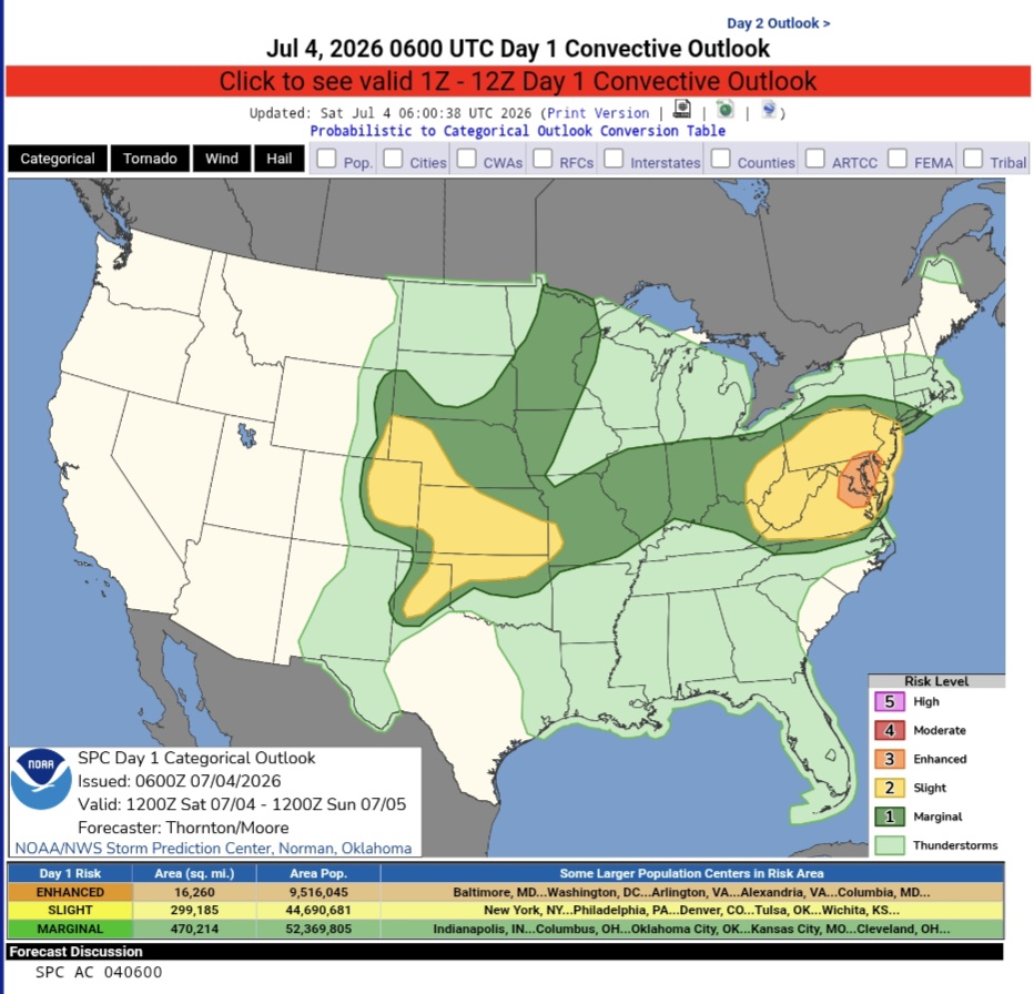
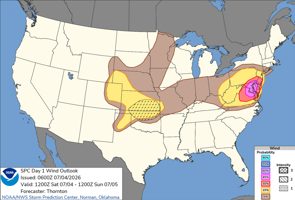
Happy Independence to those who acknowledge the United States is the greatest country in the world ,and all those who serve and have served America. Stay safe out there, especially, you extreme southeastern folk. Day 1 Convective Outlook NWS Storm Prediction Center Norman OK 0100 AM CDT Sat Jul 04 2026 Valid 041200Z - 051200Z ...THERE IS AN ENHANCED RISK OF SEVERE THUNDERSTORMS PORTIONS OF THE MID-ATLANTIC... ...THERE IS A SLIGHT RISK OF SEVERE THUNDERSTORMS ACROSS PORTIONS OF THE CENTRAL/SOUTHERN PLAINS... ...SUMMARY... Clusters of storms will move across parts of the Allegheny Plateau into Mid Atlantic, with potential for widespread damaging wind. Additional thunderstorms are expected across the Great Plains Saturday afternoon and evening, posing a risk for damaging wind gusts. Large hail is also possible across the Great Plains. ...Synopsis... Height rises will continue across the western US, with more zonal flow across the central US and upper-level troughing across the Northeast and Quebec/Ontario. A modest belt of westerly flow around 30-40 kts will move through the trough in the Northeast/Mid-Atlantic. A compact shortwave trough with enhanced westerly flow will move through the flow across the Central Plains. ...Eastern Ohio Valley into the Mid-Atlantic... Activity will likely be ongoing across some portion of northern PA into northern NJ this morning. This will likely contribute to lingering cloud cover and more muted daytime heating/recovery with northern extent. South of the morning precipitation, strong daytime heating and warming is expected, with temperatures climbing into the 90s to 100s F. A plume of steep mid-level lapse rates is already in place across the region from WV into VA/MD/NJ. With daytime heating, low-level lapse rates are expected to increase with moderate to strong instability by the afternoon. Deep layer shear profiles will be generally weak, with better shear to the north. Nonetheless, several thunderstorm clusters are expected to develop across the Blue Ridge Mountains/Shenandoah Valley moving north and eastward though the afternoon. These will have the potential to produce widespread damaging wind, especially if clusters can grow upscale and develop strong cold pools. https://www.spc.noaa.gov/products/outlook/day1otlk.html
-
 Today looks pretty meh in the heat department. Progged SW will keep it comfy. Maybe I can convince my wife to open the windows.
 -
75.9/70/77 right now.
-
 How do storms look later today?
 -
In the latest AFD from LWX... National Weather Service Baltimore MD/Washington DC 400 AM EDT Sat Jul 4 2026 .WHAT HAS CHANGED... Given an uptick in today`s heat index forecast, have upgraded to Extreme Heat Warnings across north-central Maryland down across the eastern West Virginia Panhandle into the Shenandoah Valley. For today`s convective threat, the Storm Prediction Center has upgraded to an Enhanced Risk for severe thunderstorms across locations east of the Blue Ridge Mountains. (snip) Before convection enters the picture, it will be another day of record warmth across the Mid-Atlantic region. Using 850-mb temperatures as a proxy, forecast readings should be around 22-23C which dry adiabatic mixing favors another 100 degree day. Adding continued tropical moisture in place will support heat indices pushing into the 105 to 110 degree range. Extreme Heat Warnings are in effect from 10 AM until 9 PM for areas east of the Blue Ridge. (snip) Although vertical shear is only around 20 to 25 knots, any storms able to tap into the robust instability will be capable of damaging winds. Some of this could be locally destructive with gusts up to 60 to 75 mph. (snip) The primary signal east of the Blue Ridge is in the 3-9 PM timeframe, slightly earlier to the west. Damaging to locally destructive winds are the main threat, with any chance for large hail being minimal given the summertime freezing levels. (snip)
-
 Lots of spread on ensembles. Will be a very narrow area . Rest of the area will just be meh
 - Today
-

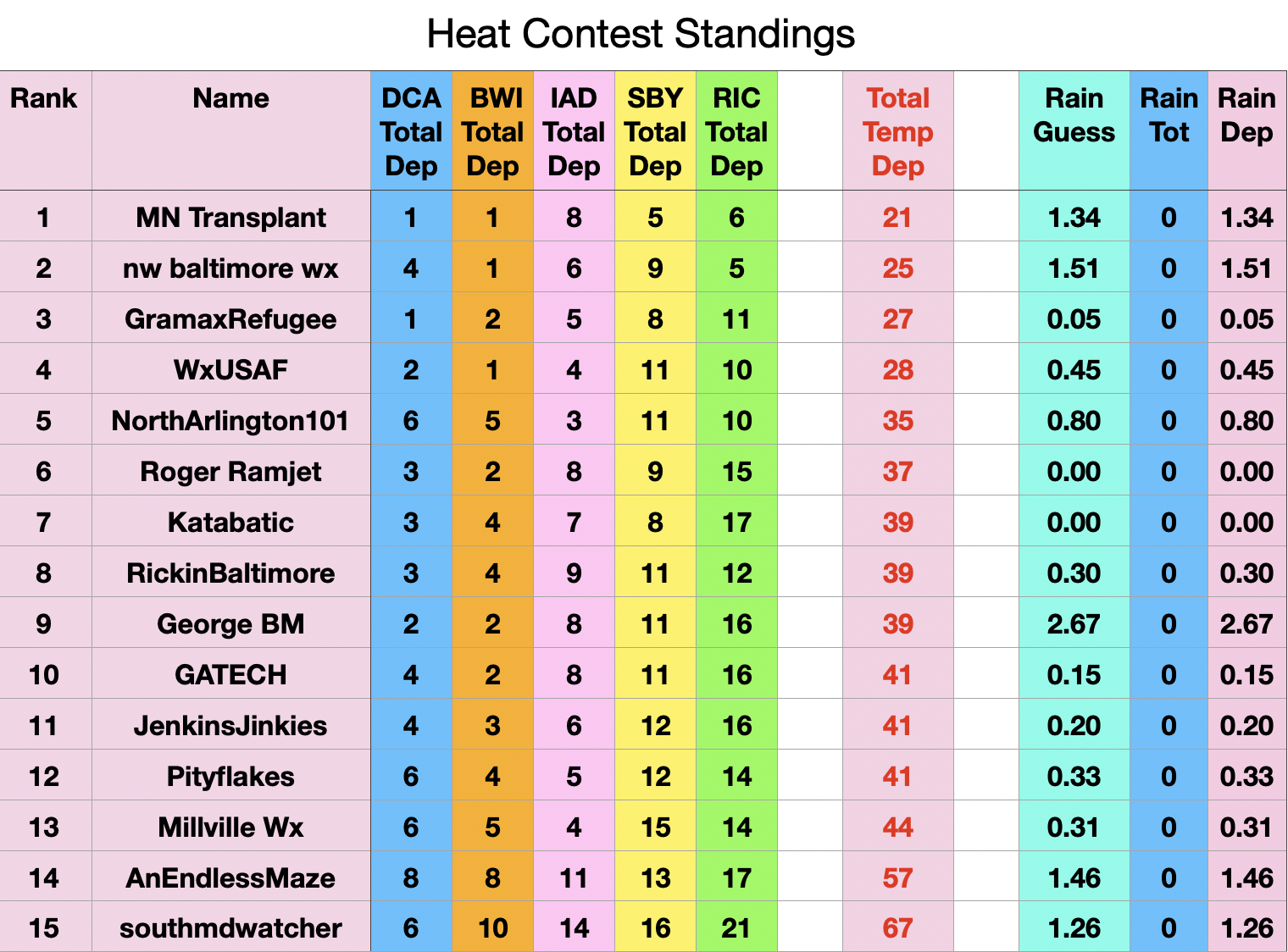
Fireworks Heat Contest W 7/1 - S 7/4 for Five MA Airports
nw baltimore wx replied to nw baltimore wx's topic in Mid Atlantic
The high temps used for Friday, 7/3, are: DCA 102, BWI 102, IAD 98, SBY 101, and RIC 99. I'd appreciate anyone checking that I am accurate, and if so, these are the current standings.
-
They were moving east to west earlier then started moving S to N. My current forecast is dry tomorrow but you guys may have a better shot at storms.
-
I was actually at Turkey Creek in a movie and it thundered there and had rained when I came out. East of there was drier and I got back here as the storm was hitting hard. It moved S to N.
-
The amount of rain, thunder and cloud to ground lightning earlier tonight was absolutely wonderful
-
SPC has an ENH 45% for wind over parts of the region. While DCAPE is good, overall tstm coverage does not suggest widespread high winds. And deep layer wind shear is weak so you will not likely have organized short bow or line segments moving rapidly in one direction. This does not mean any wind event will not be significant or very damaging locally, but you do not need ENH for that. You do not need even SLGT, as low svr probs say nothing about the intensity of any given individual svr event in the outlook area. 30% for wind objectively seems better. The ENH and 45% area almost bisects much of Chesapeake Bay. I have to think due to it being the 4th of July, DC, and 250 events, the ENH is due to this. I have no proof of course, but let's honest w/ ourselves. I have pointed out before there is an odd bulls-eye for frequency of svr tstm watch center over the DC area. That's is not likely due to climo. The social/economic/political do influence alerts/watches/warnings at times. .
-
Day 1 Convective Outlook NWS Storm Prediction Center Norman OK 0100 AM CDT Sat Jul 04 2026 Valid 041200Z - 051200Z ...THERE IS AN ENHANCED RISK OF SEVERE THUNDERSTORMS PORTIONS OF THE MID-ATLANTIC... ...THERE IS A SLIGHT RISK OF SEVERE THUNDERSTORMS ACROSS PORTIONS OF THE CENTRAL/SOUTHERN PLAINS... ...SUMMARY... Clusters of storms will move across parts of the Allegheny Plateau into Mid Atlantic, with potential for widespread damaging wind. Additional thunderstorms are expected across the Great Plains Saturday afternoon and evening, posing a risk for damaging wind gusts. Large hail is also possible across the Great Plains. ...Synopsis... Height rises will continue across the western US, with more zonal flow across the central US and upper-level troughing across the Northeast and Quebec/Ontario. A modest belt of westerly flow around 30-40 kts will move through the trough in the Northeast/Mid-Atlantic. A compact shortwave trough with enhanced westerly flow will move through the flow across the Central Plains. ...Eastern Ohio Valley into the Mid-Atlantic... Activity will likely be ongoing across some portion of northern PA into northern NJ this morning. This will likely contribute to lingering cloud cover and more muted daytime heating/recovery with northern extent. South of the morning precipitation, strong daytime heating and warming is expected, with temperatures climbing into the 90s to 100s F. A plume of steep mid-level lapse rates is already in place across the region from WV into VA/MD/NJ. With daytime heating, low-level lapse rates are expected to increase with moderate to strong instability by the afternoon. Deep layer shear profiles will be generally weak, with better shear to the north. Nonetheless, several thunderstorm clusters are expected to develop across the Blue Ridge Mountains/Shenandoah Valley moving north and eastward though the afternoon. These will have the potential to produce widespread damaging wind, especially if clusters can grow upscale and develop strong cold pools. Additional clusters are likely in the wake of morning convection further north. Instability will be less, but sufficient deep layer shear may support one or more clusters capable of damaging wind.
-
88/74/96 at 3am at DCA... toasty
-
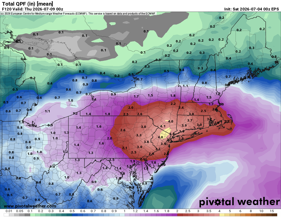
 Pretty high amounts on the EPS.. good sign someone is going to get crushed
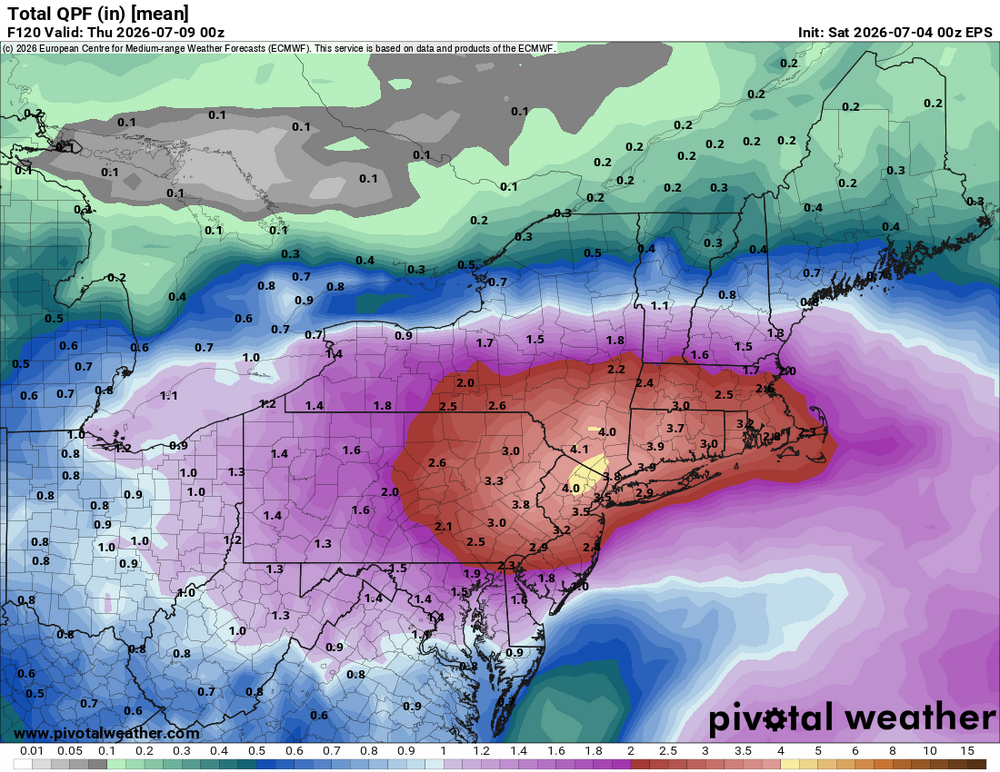
-
Bit of a surprise... ENH and 45 wind up on early morning Day 1
-
 Scott rain PT.
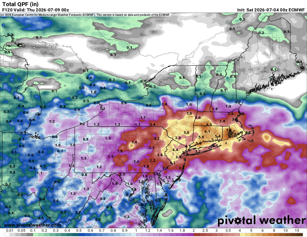
-
CMC GFS and Euro flood early this coming week
-
looks much much better now
-
Same with sweetwater. Pretty intense lighting too. Havent had a storm like that in a long while. It’ll be interesting to see how storms setup tomorrow with the Hight setting more in Kentucky. .
- 321 replies
-
- 1
-

-
- severe
- mountain snow
- (and 1 more)
-
DCA officially had an 87/80 on the 1am ob for a heat index of 103F. Come on man.
-
Only Ineedsnow would say MEH to a 140 kt STY! It's the CoastalWx equivalent of saying MEH to 6/1/11.
-
Take a look at this short paper from 2004. Odds are it has been exceeded, and since 2004? Several candidates (Haiyan in Nov 2013 almost certainly). strongerTC.pdf
-

E PA/NJ/DE Summer 2026 Obs/Discussion
Albedoman replied to PhiEaglesfan712's topic in Philadelphia Region
https://www.mcall.com/2026/07/03/lehigh-valley-storm-damage-photos-july-3-2026/ -
If we only have recon in these monsters. I will tell you given what recons measured from the 1940s to 1987 in the WPAC, if it was done today w/ the much more advanced tech such as GPS dropsondes and the SFMR, you want to talk records and extreme that would put all to shame what we have seen in recons in the ATLC? The few research mission recons we have had over the years in the WPAC have shown incredible stuff. Satellite estimates can only do so much. Dvorak estimates work best for TCs between 60 and 105 kt. This means two things - 1) many TDs are actually weak TSs, and 2) most very intense TCs are underestimated. The inner core of these things are strange beasts, acting more mesoscale than anything when you get to Cat 5 levels. EPAC Patricia in 2015 would have been capped at 160 kt from satellite estimate only, but recon actually found 185 kt winds. As a result of the above, TC intensities and annual ACE globally are underestimated, and the further you go back, esp. prior to the satellite era, the more off it is. And really w/ recon, we only started to see things in proper detail w/ the advent of the GPS dropsonde in the late 1990s and the SFMR in 2004. So you can't really use the database we have over the long-term for true TC trends.
-
E PA/NJ/DE Summer 2026 Obs/Discussion
Albedoman replied to PhiEaglesfan712's topic in Philadelphia Region
Yep my area was the hardest hit from the these storms this evening- from 102 temps down to the mid 70's comes with derecho type straightline winds like I said earlier this week could happen. Only .31 in of rain but the winds were bad. Spent an hour picking up dead limbs/branches in the yard and street. this happened less than 1 mile from the house---- Severe thunderstorms moved through the Lehigh Valley on Friday evening, temporarily dropping temperatures amid the extreme heat, but also causing significant tree damage that cut power to thousands of area residents just as Fourth of July celebrations get started. Some of the worst storm damage was reported in the Alburtis and Macungie areas, where numerous downed trees dotted the landscape. Alburtis declared a “state of emergency” due to the damage. “Please avoid unnecessary travel, stay clear of downed trees and power lines, and follow all guidance from emergency personnel,” according to a post on the borough’s Facebook page around 9:30 p.m. “Updates will be provided as crews continue assessment and restoration efforts.” One tree fell onto a house on West Fifth Street in the borough, tearing away part of the roof. A freight train was also stopped in the borough due to a large tree that fell on the tracks, blocking both railroad crossings on North Main Street and West Penn Avenue. As of 8 p.m., PPL’s outage map reported nearly 12,000 customers without power in Lehigh and Northampton counties. Areas reporting more than 1,000 outages included Washington Township, Upper Milford Township, South Whitehall Township and Lower Macungie Township in Lehigh County, as well as Northampton borough and