All Activity
- Past hour
-

Possible coastal storm centered on Feb 1 2026.
NoCORH4L replied to Typhoon Tip's topic in New England
Why doesn't anyone use the NAVGEM anymore? It's good enough for the Navy! -
He definitely did lol. Now we just need to send him the bat signal to tell us the models will start catching on by this time tomorrow.
-

The “I bring the mojo” Jan 30-Feb 1 potential winter storm
wncsnow replied to lilj4425's topic in Southeastern States
It was unlikely the coastal would give us much anyways. Its all ULL/leeside enhancement or bust. -
Time for a model blackout for me. Ill come back around this time tomorrow. Will know then if its done and cooked or alive and well.
-
i believe @psuhoffmansaid those would probably show up around this time
-

The “I bring the mojo” Jan 30-Feb 1 potential winter storm
mstr4j replied to lilj4425's topic in Southeastern States
Im afraid I can predict who the big losers will be...lol -

The “I bring the mojo” Jan 30-Feb 1 potential winter storm
BooneWX replied to lilj4425's topic in Southeastern States
Agreed because it hasn’t really waivered on evolution or footprint, just some ticks down in precip. Virtually no track shift the last few runs. -
Jan 96 and 2016....no complaints here.
-

The “I bring the mojo” Jan 30-Feb 1 potential winter storm
ADB83 replied to lilj4425's topic in Southeastern States
I think all I can say with any confidence is at least measurable snow has become more likely for most of North Carolina. If you take the runs both the deterministic and the ensembles, and yes, AI has a seat at the table now too I suppose, I think miserable snow has become more likely for a good portion of the state. Still have to iron out the details and there are a lot of details still, but that seems to be a growing model consensus and even an increasing confidence from local Mets, etc. . -

The “I bring the mojo” Jan 30-Feb 1 potential winter storm
AirNelson39 replied to lilj4425's topic in Southeastern States
I’m not hanging my hat until 00z tomorrow night. If this thing does miss the phase and stays off shore I think we have to consider weather next 2 the new king though, at least for winter storms. -
With the road conditions around my neighborhood, even a 1-3 inch snowfall followed by another week of frigid weather would have a very outsized impact. Looks like my days in VT out there right now.
-

January 2026 regional war/obs/disco thread
ChangeofSeasonsWX replied to Baroclinic Zone's topic in New England
I've always wondered if I will ever see a blizzard in my life that beats 1978 totals. With climate change it seems less likely but we've still had some massive storms the last couple of decades so I guess anything is possible. But it goes to show you just how rare and special that storm really was. 1996 came close but that was six months before I was born. 2005 was the biggest of my life and that was fun. 2013, 2015, and 2022 were amazing also. -

The “I bring the mojo” Jan 30-Feb 1 potential winter storm
StantonParkHoya replied to lilj4425's topic in Southeastern States
Theres going to be some splitting of the herds here come Thursday if this keeps looking this way, with WNC / SC folks needing one thread, and C/ENC/VA folks needing another. -
It was ever so slight, but the Weather Next moved the precip slightly west and slightly more for most of East Tn vs 06z. So a small step in the right direction.
-

The “I bring the mojo” Jan 30-Feb 1 potential winter storm
olafminesaw replied to lilj4425's topic in Southeastern States
12Z Full phase: Canadian, GFS, Partial/late Phase: Euro⏫, Euro AI, AI GFS No phase: UKMET⏬, ICON, NEXT model⏬ Confidence is growing in the partial phase scenario, but all options still on the table -

The “I bring the mojo” Jan 30-Feb 1 potential winter storm
Shad replied to lilj4425's topic in Southeastern States
Has Weathernext been tested with a setup like this before? How much should we put into the model? -

The “I bring the mojo” Jan 30-Feb 1 potential winter storm
BornAgain13 replied to lilj4425's topic in Southeastern States
Someone may have already answered this and I highly doubt the 12z GFS is right, but does it or does it not handle the northern stream better than most guidance? -
The “I bring the mojo” Jan 30-Feb 1 potential winter storm
wncsnow replied to lilj4425's topic in Southeastern States
So maybe Gemini wasn't totally lying. You can see the heavier precip near the Blue Rudge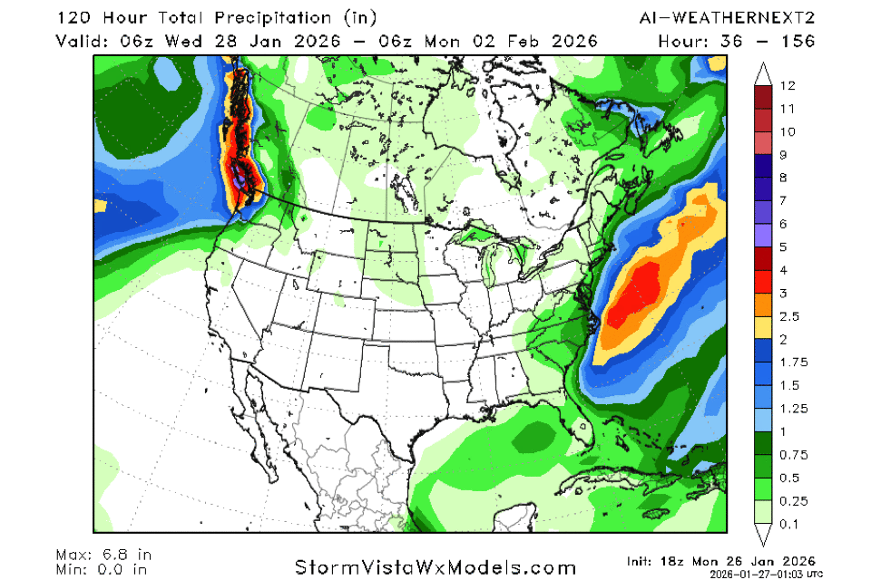
-
The GFS was 500 miles off on the other hand.... GFS Model – MSLP & Precip for Eastern U.S. | Tropical Tidbits
-
Best we can hope for is that north ULL maybe around N NC. Negative tilt in E KY would be nice but might be a bridge too far. I’d be happy with like a 3-6 deal all snow. Maybe some wind. We’ll see
-

E PA/NJ/DE Winter 2025-26 Obs/Discussion
Newman replied to LVblizzard's topic in Philadelphia Region
Ridge out west is a bit more amplified on the GFS, better wave separation between our 50/50 and NS shortwave cutting off, and the decaying NAO block is a bit more stout on the GFS forcing the wave more meridional -> pinches off sooner. You're right though, things don't look too dissimilar broadly but it's such a nuanced setup. Looking ahead, you want to see the GFS continue these trends and/or hold them. And need the Euro to adopt greater wave separation with our stretched out TPV. We want subtle ridging to build into New England where the Euro right now has the vorticity ribbon draped and keeping heights too low. -
The “I bring the mojo” Jan 30-Feb 1 potential winter storm
BooneWX replied to lilj4425's topic in Southeastern States
I know it’s depressing when we’re all coming off the GFS and Canadian highs from earlier, but don’t sleep on that ULL. It’s the type of setup that’ll lull you to sleep until Thursday night when the CAMs really come into range and can analyze the convective setup. There would be some BIG winners and some big losers. One of those storms where someone gets a death band to the northwest of the ULL. -
The “I bring the mojo” Jan 30-Feb 1 potential winter storm
wncsnow replied to lilj4425's topic in Southeastern States
Verbatim its still a nice 2-4 or 3-6 storm (high ratios) for most of WNC and SC. -
Last Tuesday 12Z EURO (it ended up further north by 100 miles or so, but not 500 miles) ECMWF Model – MSLP & Precip for Northeast U.S. | Tropical Tidbits


