All Activity
- Past hour
-
Update: it’s mid April and the cold is nowhere to be found, my area is expected to be 80 the next 3 days. I’m planning to install my AC tonight. Just a month and a half ago I was buried under feet of snow, kind of nuts how quick the seasonal transition was this year. Very warm start to spring.
-

2026-2027 El Nino
snowman19 replied to Stormchaserchuck1's topic in Weather Forecasting and Discussion
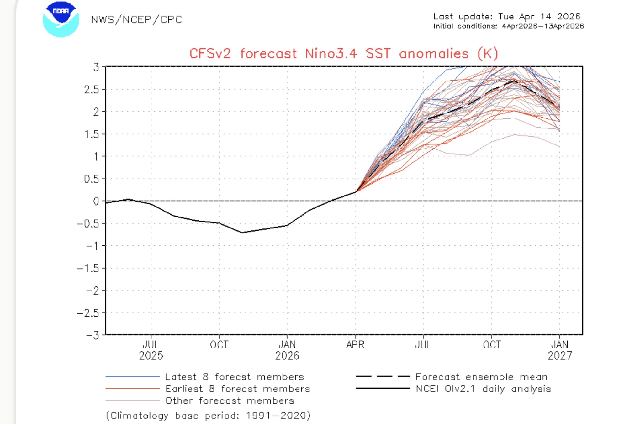
Given the totality of the indicators up to now, I think it goes super. Then the question becomes is it east-based/East Pacific (1997-98, 1982-83) or basin-wide (2015-16) -

2026-2027 El Nino
bluewave replied to Stormchaserchuck1's topic in Weather Forecasting and Discussion
If the models are still showing something similar with the June updates, then our first 2.0°+ ONI El Niño events within 3 years would become more likely. -
Landscaping should really start popping this week with the breaks of sun
-

2026-2027 El Nino
40/70 Benchmark replied to Stormchaserchuck1's topic in Weather Forecasting and Discussion
Important to see how the PDO evolves, too.....I don't think that it will, but if it were to remain negative with the RONI continuing to lag to ONI, then good night nurse. -

Central PA Spring 2026 Discussion/Obs Thread
WmsptWx replied to Voyager's topic in Upstate New York/Pennsylvania
Stepped outside last night to get a bag out of my car and saw lightning off in the distance. No storms over my head but there must have been one somewheres. Very ready for heat and hopefully storms. -
Curious if today busts MOS by a bit. MET/MAV are 78 to 82-sish along the BDL-FIT-ASH arc here in the interior. +14.5 C at 850, and the mixing layer appears capable of being that high today ..., extrapolates to about 27.5 C at the 1000 mb hash on the skew t plot, and that doesn't include the slope to the 2-meter T. Probably 30 C at the absolute bottom if/when these skies remain this sunny along with these other synoptic circumstances. Deep layer flow is WSW like this and not over-bearing DP whilst a 50+ launch should be 84 or 85 to allow April to force a conserved high. A month from now I'd even go 87
-
2026-2027 El Nino
snowman19 replied to Stormchaserchuck1's topic in Weather Forecasting and Discussion
This is starting to look like a lock for a “high-end” strong El Niño at the very minimum -
2026-2027 El Nino
40/70 Benchmark replied to Stormchaserchuck1's topic in Weather Forecasting and Discussion
2023 would be my top analog, though probably not quite as warm and snowless given a bit more favorable of a look in the north Pacific. -

2026-2027 El Nino
George001 replied to Stormchaserchuck1's topic in Weather Forecasting and Discussion
I do agree that northern areas aren’t necessarily doomed even if the Nino is on the stronger side, especially the great lakes (I know you guys do better in La Nina’s, but I do remember seeing somewhere that a super Nino is less of a death sentence for you guys than my area. I’d still prefer a weak or moderate event, but the early signs are this is developing more like recent strong or super ninos than the weak/moderate bucket. If it does become a super Nino I would go fairly aggressive on the mild and less snow side, but not necessarily if it is strong but not super and the non ENSO indicators look good (like you mentioned this is key, and is why this past winter was such a good one). Even last winter wasn’t an optimal ENSO configuration, and still was the best winter I had since 2014-2015. The east based nina idea like 17-18 and 21-22 didnt pan out, it shifted from more basin wide to a modoki Nina in the second half of winter. I recall looking in late Jan and being surprised at how much the coldest anomalies shifted west. We will see how things play out, id roll the dice with an 09-10 ENSO configuration with less blocking, so hopefully things break right in that regard. -
2026-2027 El Nino
40/70 Benchmark replied to Stormchaserchuck1's topic in Weather Forecasting and Discussion
So 2.0 RONI and 2.5 ONI....not good. I'll go torch if that remains consistent. I would rather see the RONI higher. -
2026-2027 El Nino
bluewave replied to Stormchaserchuck1's topic in Weather Forecasting and Discussion
Similar to the Euro which is what you would expect if these record WWBs continue past the spring forecast barrier.
-
Nice! Take a little ride up 81 and check out the snow towns. Pulaski is a beautiful little town. Oswego is another cool little snow town on the lake. Or head up the Tug Hill to Highmarket. That's big snow country up there.
-
Off to the races today with a high launching pad-already 60 here
-
I'd like to see a couple more runs with a modicum of realized continuity on that. The Euro and particularly GGEM the most, appear too conserved ( to me ... ) wrt a wave ejecting E through a ridge trying to amplify at that time. The GFS, pains me to admit ... is damping that waves ability to materialize that feature; which in the total synoptic manifold/evolution over those days really argues it should. Anyway, so the former rides a mid level wind max over a series of stacked outflow boundaries and oatmeals a Miller B out of 1010 mb layout... okay -
-
Looks like storms will mostly stay north and east today like yesterday. We'll give it another shot tomorrow with that next round.
-
MJO phase 8 to 1 in late April is a -NAO vibe but with AN tendency in NNE especially as you move east and north. “Best in Maine”. You can see that happening with the development of a weak coastal in gulf of Maine late Friday into early Saturday. That will send the boundary down to the mid Atlantic around Long Island with nasty easterly fetch. Guidance still catching on.
-
2026-2027 El Nino
40/70 Benchmark replied to Stormchaserchuck1's topic in Weather Forecasting and Discussion
What does it have for the ONI? -
mm... storms turn right. I wouldn't be surprised if Mohawk Trail initialization starts peeling S ...sending more anvil up our way.
-
Okay…second to last game of the regular season.
-
I was shocked to see the overnight NAM solutions back off the Wednesday afternoon BD arrival for eastern region. I think what's actually happening is that there isn't a ton a synoptic support/structure for genesis and subsequent motion in this case. It appears the models have been handling rain cooled air. There's are periodic/ nondescript convective pulses of QPF running W-E up in central and NNE, and coupling outflow with GOM oceanic cold is causing subtle +PP discontinuities. They can be real though.. but seeing the NAM back off is a red flag that convective logistics with outflow is problematic.
-
Textbook lenticulars over Spruce Pine yesterday. Sent from my Pixel 10 Pro using Tapatalk
- Today
-
HRRR is fun for later
-
Congrats Route 2 north today. Steined south
-
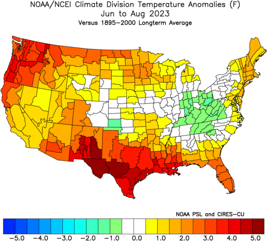
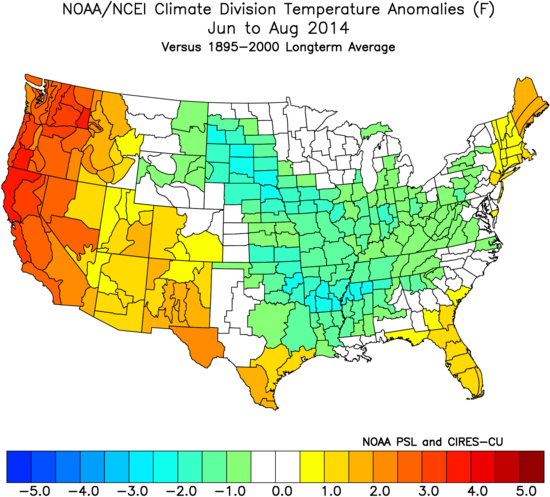
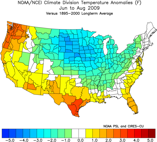
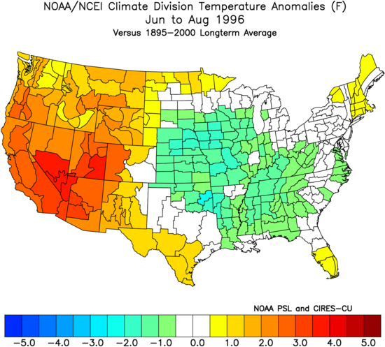
There was very heavy rain and flooding early that July before the warmer conditions arrived as the El Niño first began to take hold. The late spring that year was defined by the record warmth in Canada and drought leading to all the wildfires and the record poor air quality conditions in NYC in early summer. That being said, each year is different which variation from previous El Niños. While it was a cooler summer relative to the 2020s, it was still warmer than most summers in the earlier decades. The progress of “cooler” summers since the 1990s