All Activity
- Past hour
-
It feels cooler and less humid than it did earlier. It feels like the stable air has made it to the lowlands.
-
I need my 58 degree morning temperatures to return with zero humidity and a dew point of 45. That's just heaven.
-
1953 - The worst tornado of record for the state of Michigan killed 116 persons. Flint MI was hardest hit. The tornado, half a mile in width, destroyed 200 homes on Coldwater Road killing entire families. (The Weather Channel) Interesting you had a tornado on this date in 1953, we had a historic one in 1953 in the northeast too, in Worcester, MA. 1953 was a historically hot summer here with our longest streak of 90 degree days ever (with two historic hot stretches with 4 100+ stretches split between the two superheatwaves!)
-
Records:Highs:EWR: 99 (2011)NYC: 95 (1933)LGA: 97 (2011)JFK: 96 (1999) 1999 and 2011 the summer gifts that kept on giving lol
-
These models just can’t see the Southeast Ridge and strength of the Pacific Jet past 120 hrs. So the snowfall beyond 120 hrs has been shifting further north over time. February was a prime example of this model bias. The 30”+ totals which were forecast around NYC wound up much further north. Places like Toronto to Montreal got the record snowfall instead. This has been a very predictable model forecast error for my area in recent years. So instead of the 30-40” model forecasts for NYC, they finished February with 7.1”.
-
sunny and low humidity and a nice breeze!!
-
The evening forecasts last night showed we would be mostly sunny today I don't care what happens after 5 pm lol
-
it's good to see a day of sunshine-- today has been sunny from the start also less humid
-
AI and quantum computing should be able to help with this too.
-
That actually reminds me of February 1989
-
omg I've never experienced anything like that, in 1993 we had 3 straight days of 100+ which peaked at 102 on the third day and that was my best heatwave ever.
-
I think the haze/smoke is worse today than any of the days last week. Even the close in mountains have a hazy look, and unless I'm imagining it again, can sometimes smell a little smoke. Especially when I first walk out of the house.
-
only .04 from any rain the past 2 days recapping last week, my highs Thurs-Sat were 88, 89, 89 and 80 yesterday....still without a 90 this year. bad weekend weather pattern looks like it will continue next weekend
-
I don't doubt it. Sun angle popped into my head as a joke since we hear so much about it here but there could actually be something to that. The sun is actually out a bit up here this morning, I wonder what's wrong.
-
Hmmm FXUS61 KLWX 081335 AFDLWX Area Forecast Discussion National Weather Service Baltimore MD/Washington DC 935 AM EDT Sun Jun 8 2025 .SYNOPSIS... A cold front will slowly settle southward toward the area through today, then meander across the Mid-Atlantic through Monday. A stronger cold front will cross the area on Tuesday night, followed by high pressure Wednesday and Thursday. && .NEAR TERM /THROUGH TONIGHT/... Next shortwave trough and accompanying area of low pressure will track ewd from eastern Ohio and across Pennsylvania this afternoon providing ample lift for showers and thunderstorms in a warm, humid, and unstable air mass. As of this morning, the wavy stalled front is located generally from Staunton to the Northern Neck. Cloudy and showery conditions continue north of this boundary this morning, with a few embedded heavier showers ongoing in central VA. This activity is expected to slowly diminish by early afternoon as the warm front lifts north into our area. Where the front ultimately stalls will be important for the severe/flood threat. The most unstable airmass is likely to be south of US-50. The early 12Z guidance looks to have the warm front along the Potomac River, possibly some of it stretches up into MD just south of I-70. The greater SRH will be along and east of the boundary, though deep-layer shear of 35-45 knots looks to be plentiful across most of the area. Will be looking to see where these gradients ultimately set up as that will point to the corridor of most likely severe weather.
-
First bust of the summer?
-
Gorgeous outside!!
-
Haha It's the Sun, the breeze, the temp and the dewpoints all screaming "beach" for some reason, at least to me down here by the coast.
- Today
-

2025-2026 ENSO
michsnowfreak replied to 40/70 Benchmark's topic in Weather Forecasting and Discussion
This is the deadliest heatwave on record in the U.S. Detroit saw temps over 100° for 7 straight days (peaking at 104 on day 1 and 7). The city allowed people to sleep in parks since their homes/apartments were baking. The MI state record was set in Mio with a temp of 112°. -
The sun angle
-
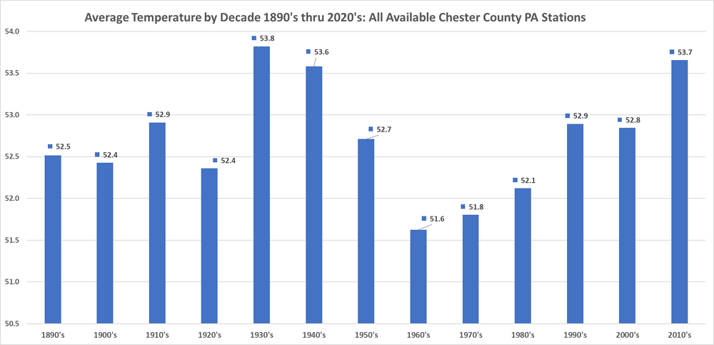
Funny how Charlie picks his starting point as 1970...I wonder why?? Oh wait I see it below - he starts with our coldest decade...cyclical climate change FTW!!
-
Font / boundary pushed south with the main area of rain and heavy rain into SPA W-MD/VA - creeps back Mon night / Tue wit our next widespread showers, rains, storms
-

2025 Lawns & Gardens Thread. Making Lawns Great Again
DavisStraight replied to Damage In Tolland's topic in New England
Every dog I've had (4 dogs) except for the current pup have been sprayed, nasty smell but I keep hydrogen peroxide, baking soda and dawn in the house just in case. -
Something about this morning's weather feels like beach weather right now
-


