All Activity
- Past hour
-
you all act like the unknowns could lean in the snowier direction but not in the warmer direction. feb 98 in detroit was +8.7 with zero snow btw
-
Ty. I’m a lucky man, I got to come home. I helped manage the derivatives risk book for Lehman Brothers. Myself, and two others had to sneak back into the building to download the firm’s risk profile. Pitch black, and a gaping hole where a beam had split the trading floor in half. PD is a very misunderstood disease. I was diagnosed 10 years ago, and it has progressed at a very slow pace. My biggest fight has been with the non motor symptoms like anxiety. Does it suck? Yes Will it kill me? No I have a beautiful family that I had to be here for. My oldest is a police officer(25), and my youngest son(22) just sold his business for a very large sum of $. He, and future generations will have a very comfortable life. I am blessed apologies to the mods for me clogging up the board with my life story. It’s all good
-
Records: Highs: EWR: 95 (1961) NYC: 94 (1961) LGA: 94 (1961) JFK: 91 (1981) Lows: EWR: 47 (1958) NYC: 46 (1917) LGA: 52 (1967) JFK: 46 (1967) Historical: 1775: The Independence Hurricane caught many fishing boats on the Grand Banks off Newfoundland Canada killing 4,000 seamen, most from Britain and Ireland. (Ref. Wilson Wx. History) 1857: The SS Central America sinks during a hurricane, killing 425 lives. Fourteen tons of gold was aboard the ship as well. 1869: A hail storm between 1 and 3 AM broke windows and caused considerable damage to late vegetables at Madilia, MN in Watonwan County. (Ref. AccWeather Weather History) 1882 - Hot and dry winds caused tree foliage in eastern Kansas to wither and crumble. (David Ludlum) 1921: The San Antonio River flooded, killing 51 people and causing millions of dollars in damages. The flood was caused by some of the heaviest rainfall ever recorded in Texas. A storm stalled over the town of Taylor and dumped an astounding 23.11 inches of rain on the area in less than a day. (Ref. Wilson Wx. History) 1944: The destroyer USS Warrington was sunk by the Great Atlantic Hurricane 300 miles east of Cape Canaveral, FL. 247 men were lost in the tragedy. The hurricane would pass just east of the North Carolina Outer Banks and make landfall on the east end of Long Island, then pass into Rhode Island. The Great Atlantic hurricane was significant because it was the first storm in which forecasters had regular aircraft reconnaissance reports available. The success convinced the military of the value of reconnaissance and the program continued and evolved to what it is today. (Ref. Wilson Wx. History) 1950: Hurricane Dog was the most intense hurricane in the 1950 Atlantic hurricane season. The fourth named storm of the season, Dog developed on August 30 to the east of Antigua; after passing through the northern Lesser Antilles, it turned to the north and intensified into a Category 5 hurricane. Dog reached its peak intensity with winds of 185 mph (300 km/h) over the open Atlantic and after weakening, it passed within 200 miles (320 km) of Cape Cod Hurricane Dog retains the record for longest continuous duration for a Category 5 Atlantic hurricane, although Hurricane Allen spent more total time as a Category 5. On September 4, Hurricane Dog was one of three simultaneous Atlantic hurricanes, along with Charlie and Easy. This is a rare occurrence in the Atlantic Ocean, and has only happened six times since 1950—in 1961, 1967, 1980, 1995, 1998, and most recently in 2010. This also occurred on August 31 with Baker, Charlie and Dog. Additionally, Dog remains one of only three Category 5 hurricanes in the historical database to avoid land—the others were Easy and Cleo, both of which also occurred in the 1950s. Why was it called the Dog Hurricane? Hurricane naming began back in 1950, when meteorologists wanted to give tropical storms and hurricanes an easy name to remember them by, instead of just plain "Hurricane Six" or "Tropical Storm 8b". So, in 1950, the National Hurricane Center named hurricanes from the World War 2 phonetic alphabet. Hurricanes that year were given names such as "Dog", "Barker", "Item", and "Jig". And yes, these names did sound a little funny, that is probably why they only used these names until 1952. In the Hurricane Season of 1953, they tried a different approach - giving the hurricanes human names. They started out just using female names, and this lasted over 25 years until in 1979, men's names were incorporated into the list. 1950: A hailstorm struck southern parts of Oklahoma City on this day. The storm damaged about 4,000 homes, 300 businesses, and 750 cars, resulting in a loss estimated at $987,000. 1960: Hurricane Donna hits the Boston, MA area. Winds were recorded to 140 mph at the Blue Hills Observatory at Milton, MA and 130 mph at Block Island, RI. Donna was the first hurricane to affect every point along the east coast from Key West, FL to Caribou, ME. (Ref. NOAA Boston Weather Events) 1963: President Kennedy gave his, “We choose to go to the moon” speech at Rice University. 1974: Another three inches of snow fell at Scottsbluff, NE bringing the early season snowfall total to 3.8 inches. Saratoga, WY received 4 inches of snow. (Ref. Wilson Wx. History) 1977 - Thunderstorms deluged the Kansas City area with torrential rains in the early morning hours, and then again that evening. Some places were deluged with more than six inches of rain twice that day, with up to 18 inches of rain reported at Independence MO. Flooding claimed the lives of 25 persons. The Country Club Plaza area was hardest hit. 2000 vehicles had to be towed following the storm, 150 of which had to be pulled out of Brush Creek, which runs through the Plaza area. (The Kansas City Weather Almanac) 1979 - Hurricane Frederick smashed into the Mobile Bay area of Alabama packing 132 mph winds. Winds gusts to 145 mph were reported as the eye of the hurricane moved over Dauphin Island AL, just west of Mobile. Frederick produced a fifteen foot storm surge near the mouth of Mobile Bay. The hurricane was the costliest in U.S. history causing 2.3 billion dollars damage. (David Ludlum) (The Weather Channel) 1986: 6 to 12 inches of rain in three days resulted in record flooding from Muskegon, MI to Saginaw, MI. The flooding was worsened by the collapse of several dams. 10 people were killed and damage estimates approached $500 million dollars. (Ref. Wilson Wx. History) 1987 - Showers and thunderstorms produced heavy rain which caused flooding in North Carolina, West Virginia, Virginia and Pennsylvania. Parts of Virginia received 3 to 4 inches of rain in just two hours early in the day. Later in the day, three to five inch rains deluged Cumberland County of south central Pennsylvania. Evening thunderstorms produced seven inches of rain at Marysville PA, most of which fell in three hours time. (The National Weather Summary) (Storm Data) 1988 - An afternoon tornado spawned a tornado which skipped across northern sections of Indianapolis IN damaging roofs and automobiles. It was the first tornado in central Indiana in September in nearly forty years of records. Hurricane Gilbert plowed across the island of Jamaica, and by the end of the day was headed for the Cayman Islands, packing winds of 125 mph. (The National Weather Summary) (Storm Data) 1989 - Snow whitened the mountains and foothills of northeastern Colorado, with eight inches reported at Buckhorn Mountain, west of Fort Collins. Two to three inches fell around Denver, causing great havoc during the evening rush hour. Thunderstorms produced severe weather in the Southern Plains Region between mid afternoon and early the next morning. Thunderstorms produced hail three inches in diameter at Roswell NM, and wind gusts greater than 98 mph at Henryetta OK. Thunderstorms also produced torrential rains, with more than seven inches at Scotland TX, and more than six inches at Yukon OK. (National Weather Summary) (Storm Data) 1993: The high temperature in Fort Collins, CO was 94°. A strong cold front dropped the temperature overnight and by 10 a.m. the next morning, it was 33° with 3 inches of snow on the ground. (Ref. Wilson Wx. History) 1997: Hurricane Linda became the strongest storm recorded in the eastern Pacific with winds estimated at 180 mph and gusts to 218 mph. For a time it threatened to come ashore in California as a tropical storm, but the storm turned away, impacting the region only with added moisture for showers and thunderstorms. (Ref. Wilson Wx. History) 1999: Extremely dangerous Hurricane Floyd, a Category 4 storm with top winds of 145 mph, was making residents along the U.S. East Coast very nervous as it steamed steadily westward. The storm was 360 miles east of the Bahamas, causing hurricane warnings to be raised in the islands. (Ref. Wilson Wx. History) 2008: Hurricane Ike intensified from tropical storm to Category 3 status in less than nine hours on 3 September. A few days later, Ike crossed the Caribbean and waltzed across extreme western Cuba as a Cat 3. But Ike's peak winds never regained major-hurricane force. Instead, the system simply got bigger, eventually packing some of the largest radii of hurricane-force winds (125 miles) and tropical-storm force winds (275 miles) ever measured. This posed a major public communication challenge, as the vast swath of wind was expected to stir up a storm surge in the Galveston area far worse than people might presume from the storm's Category 2 rating. The worst of Ike's surge struck less-populated areas just east of Galveston Island on the night of 12-13 September, but the overall damage was still tremendous: more than $30 billion (in inflation-adjusted dollars, that's the third costliest U.S. hurricane on record). Much of Galveston and nearby coastal towns were left in shambles, and storm-surge damage extended well east into Louisiana. Ike resulted in 82 U.S. deaths--among the highest tolls in recent decades--and more than 200 people remain missing in the hurricane's aftermath. (Washington Post "Top Ten Weather Events of 2008") 2017: Cape Canaveral Air Force Station have to reopened on September 16th after IRMA of Cat 1 hurricane gave 75 MPH force winds from Hurricane Irma that lashed the Florida Space Coast on Sunday and Monday (Sept. 10/11) – forcing launch delays and leaving damaged and destroyed homes, buildings, infrastructure and launch viewing locations in its wake. Cape Canaveral Air Force Station military forces partially reopened certain critical runways soon after Irma swept by the space coast to assist in emergency recovery operations. The “Kennedy Space Center will resume normal operations Saturday, Sept. 16,” NASA announced. Irma Data 2018: Hurricane Florence was a powerful and long-lived Cape Verde hurricane, as well as the wettest tropical cyclone on record in the Carolinas and the ninth-wettest tropical cyclone to affect the contiguous United States. The sixth named storm, third hurricane, and the first major hurricane of the 2018 Atlantic hurricane season, Florence originated from a strong tropical wave that emerged off the west coast of Africa on August 30, 2018. Steady organization resulted in the formation of a tropical depression on the next day near Cape Verde. Progressing along a steady west-northwest trajectory, the system acquired tropical storm strength on September 1, and fluctuated in strength for several days over open ocean. An unexpected bout of rapid intensification ensued on September 4– 5, culminating with Florence becoming a Category 4 major hurricane on the Saffir–Simpson scale with estimated maximum sustained winds of 130 mph
-
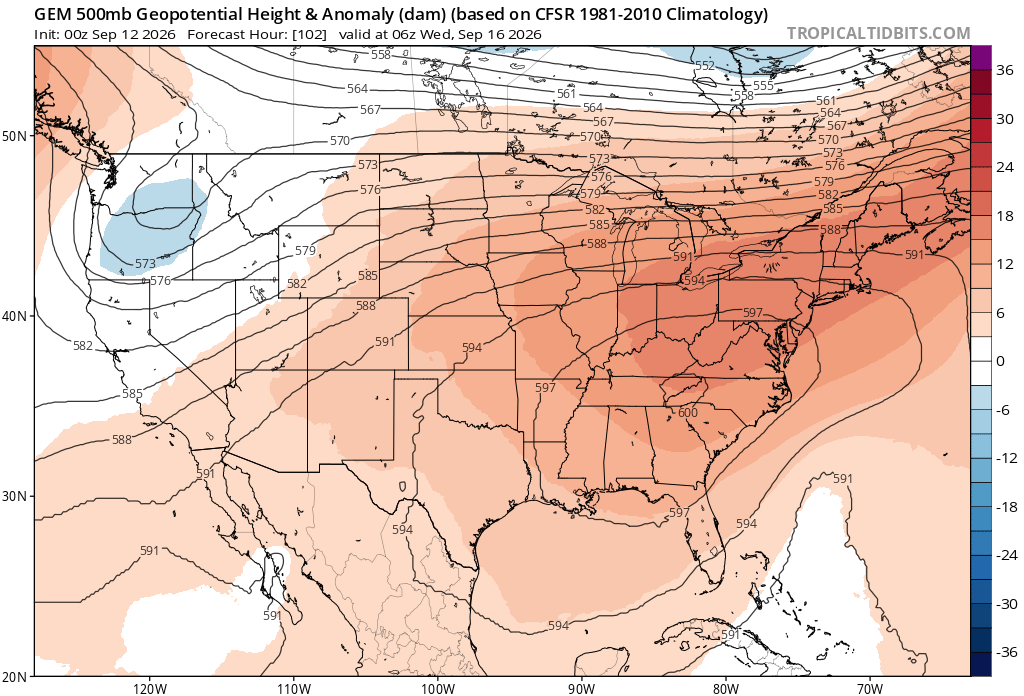
71 / 60 clear now but clouds increase later and those mostly sunny forecasts may not be so great once to the afternoon. Showers and storms/rain overnight into Sunday morning with the >0.10 rain in 10 days in this otherwise wet period. Overall warmer than normal 9/11 - 9/17 with the warmest days barring onshore flow or clouds Wed-Fri this week as ridge builds to >590 DM and 850 MB temps >20c. Beyond there back to normal and with high pressure closing off a low is a potential along the EC 9/18 - 9/22. Then way out there D10 and beyond ridge looks to build east again.
-

Septorcher 2026 Discussion - Endless Summer
dendrite replied to Damage In Tolland's topic in New England
Already Xmas stuff and eggnog in the stores. House is too cool. Enjoyment rating 2/10 -
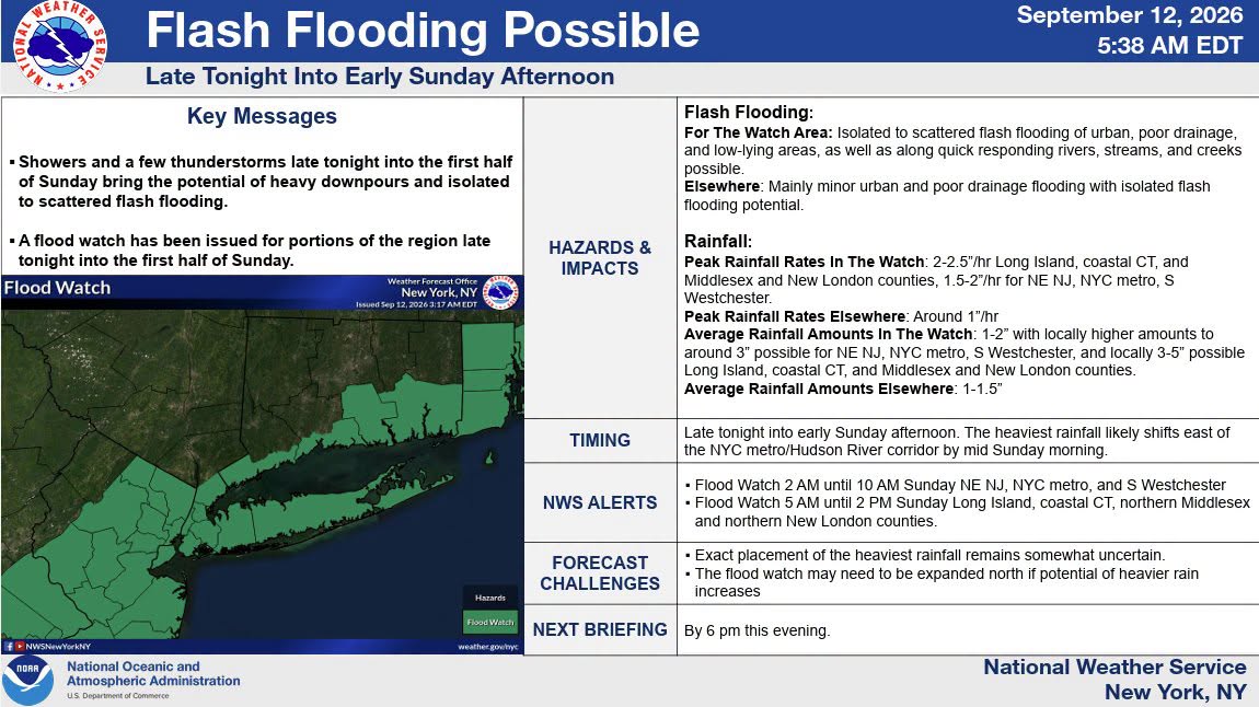
Hopefully we get pounded late tonight/tomorrow with some T-Storms.
-
Septorcher 2026 Discussion - Endless Summer
dendrite replied to Damage In Tolland's topic in New England
-
You left off a few others 1983 had the most Sep 90 degree days then followed by 2010 , 2016 , 1993. Depends on definition of endless summer. EWR 90 degree days monthly break down Rank Year Apr May Jun Jul Aug Sep Oct Total 1 2010 1 2 13 21 11 6 0 54 2T 1993 0 3 9 22 11 4 0 49 2T 2022 0 4 6 20 18 1 0 49 4 1988 0 1 10 15 17 0 0 43 5T 1991 0 8 10 9 12 2 0 41 5T 2002 4 1 5 16 14 1 0 41 5T 2021 0 4 12 11 13 1 0 41 8T 1983 0 0 7 15 11 7 0 40 8T 2016 0 3 3 16 13 5 0 40 10T 1994 0 1 9 15 11 3 0 39 10T 2025 0 0 13 12 11 3 0 39
-

Septorcher 2026 Discussion - Endless Summer
BrianW replied to Damage In Tolland's topic in New England
Yeah. Looks like a special morning tomorrow. Hoping to get in on some 2 inch rates. However, signals are starting to point to this boundary lying close to if not over Long Island/S CT after day break Sunday morning. There may also be some added lift aloft from a passing jet. The 00z HREF is showing probabilities of greater than 3 inches in 3 hours around 30 percent over urban NE NJ, NYC into Western Long Island from 09-12z Sunday with some areas 40-60 percent over central LI into the central portions of CT coast 12-15z Sunday, and around 30 percent for southeastern CT 15z-18z Sunday. We have noted in recent flash flooding events that at least a 30 percent chance of 3 inches in 3 hours has often resulted in flash flooding in parts of the urban corridor. The 00z REFS also indicated a probability greater than 50 percent for greater than 3 inch amounts in some of these same areas, specifically east of the NYC metro. There is also about a 20-30 percent probability of around 2 inch per hour rates based of data from the WPC Urban Rain Rate Dashboard. -

Central PA Summer 2026 Discussion/Obs Thread
Mount Joy Snowman replied to Voyager's topic in Upstate New York/Pennsylvania
A trace of rain and an unknown low, as it appears the batteries in my weather station have finally failed after nearly four years. - Today
-

2026-2027 Record-breaking El Nino
mitchnick replied to Stormchaserchuck1's topic in Weather Forecasting and Discussion
Flurries for you -

2026-2027 Record-breaking El Nino
GaWx replied to Stormchaserchuck1's topic in Weather Forecasting and Discussion
-

Septorcher 2026 Discussion - Endless Summer
CoastalWx replied to Damage In Tolland's topic in New England
Endless Autumn? -
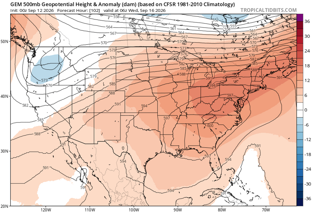
Probably more mid 80s to perhaps around 90° by later next week at the usual warm spots. So a continuation of the endless summer pattern. Really impressive to see a near 600 dm ridge in September. Very difficult to get any sustained fall cooldowns beyond 3-4 days with such strong ridges.
-

Septorcher 2026 Discussion - Endless Summer
Damage In Tolland replied to Damage In Tolland's topic in New England
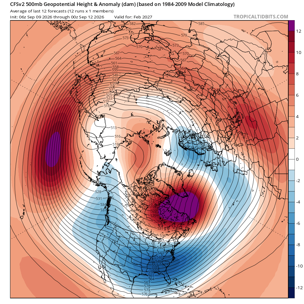
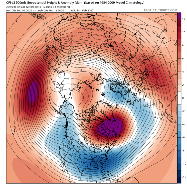
Our weather this winter will feel like we’re somewhere over Laredo it seems -
And, memorably, in January 1998. Weirdest, most unpleasant January day ever. It felt kind of like this morning does: gloomy, stifling and overcast.
-
Yeah it’s been rising quite a bit. Neutral-ish now
-
Dec. 14th
-

Occasional Thoughts on Climate Change
LibertyBell replied to donsutherland1's topic in Climate Change
Since I'm in Pennsylvania I've dug up some records. July 1936 isn't the one you should be looking at it's July 1911. The progenitor of the 11 year cycle super hot summers with some amazing heat records in the Poconos that have not been matched since and probably will never be. Climate change may increase the average temperatures but we do not get record high temperatures like that anymore. Climate change is strictly minimum driven in this part of the country. Summer record highs are more common in the West and central part of the country. Not here. This is why I caution people not to assume that a +2 c increase in averages means the highs will increase by that much or that new heat records will be set, that's not how this works. -

Central PA Summer 2026 Discussion/Obs Thread
mahantango#1 replied to Voyager's topic in Upstate New York/Pennsylvania
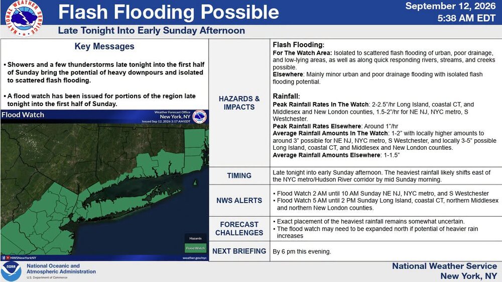
Hazardous Weather Outlook National Weather Service State College PA 442 AM EDT Sat Sep 12 2026 PAZ004>006-010>012-017>019-024>028-033>037-041-042-045-046-049>053- 056>059-063>066-130900- Warren-McKean-Potter-Elk-Cameron-Northern Clinton-Clearfield- Northern Centre-Southern Centre-Cambria-Blair-Huntingdon-Mifflin- Juniata-Somerset-Bedford-Fulton-Franklin-Tioga-Northern Lycoming- Sullivan-Southern Clinton-Southern Lycoming-Union-Snyder-Montour- Northumberland-Columbia-Perry-Dauphin-Schuylkill-Lebanon-Cumberland- Adams-York-Lancaster- 442 AM EDT Sat Sep 12 2026 This Hazardous Weather Outlook is for central Pennsylvania. .DAY ONE...Today and tonight. There is a chance for showers and storms later this afternoon into early Sunday that could result in ponding of water on roads and localized flooding. Strong winds will also be possible. .DAYS TWO THROUGH SEVEN...Sunday through Friday. There is chance for strong to severe storms Sunday afternoon into the evening hours. .SPOTTER INFORMATION STATEMENT... Spotters are encouraged to report significant hazardous weather. -
-
Probably nothing like what we had around this date in 1983. Did you check the records from 1983? That truly was the 4 month endless summer. June. July. August. September lol. The only other summers I can think of that were endless like that were 1991, 1993 and 2010. 2002 was very good too but I think that one ended in August like 1999 did. This summer has really been near normal. Each month has been hot in the first half and cool in the second half.
-
Central PA Summer 2026 Discussion/Obs Thread
mahantango#1 replied to Voyager's topic in Upstate New York/Pennsylvania
US National Weather Service State College PA Tornado #49 for PA in 2026: 972 NOUS41 KCTP 120053 PNSCTP PAZ005-120500- Public Information Statement National Weather Service State College PA 853 PM EDT Fri Sep 11 2026 ...NWS Damage Survey for 09/09/2026 Tornado Event... .Lafayette Township Tornado... Rating: EF1 Estimated Peak Wind: 105 mph Path Length /statute/: 1.23 miles Path Width /maximum/: 200 yards Fatalities: 0 Injuries: 0 Start Date: 09/09/2026 Start Time: 07:19 PM EDT Start Location: 2 WSW Cyclone / McKean County / PA Start Lat/Lon: 41.8097 / -78.6272 End Date: 09/09/2026 End Time: 07:22 PM EDT End Location: 1 WSW Cyclone / McKean County / PA End Lat/Lon: 41.8144 / -78.6054 Survey Summary: At 7:19 p.m. local time September 9, 2026 an EF-1 tornado with maximum wind speeds of 105mph touched down between Bradford Airport and Bingham Road with a maximum width of about 200 yards. It traveled east/northeast and damaged some trees around and west of Bingham Road. The tornado continued through the area of woods east of Bingham Road before doing its most intense damage along and north of Sprester Road. It uprooted and snapped many trees before flipping a trailer on its side. The tornado turned northeast and continued damaging trees into the woods before dissipating as it approached the Buffalo & Pittsburgh Railroad line around 7:22 p.m. local time. We would like to thank McKean County Emergency Management and members of the community who provided firsthand accounts, footage, and pictures of damage. && -
Septorcher 2026 Discussion - Endless Summer
CoastalWx replied to Damage In Tolland's topic in New England
Although the new RRFS 2.0 is more widespread. -
Septorcher 2026 Discussion - Endless Summer
CoastalWx replied to Damage In Tolland's topic in New England
South coast special tomorrow