All Activity
- Past hour
-
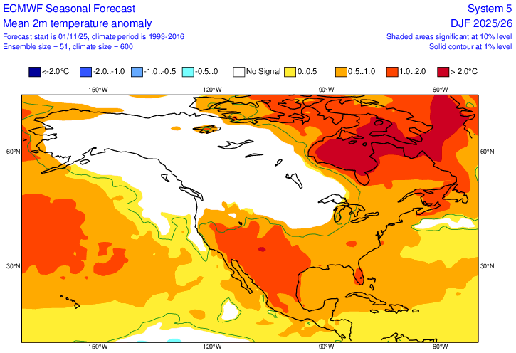
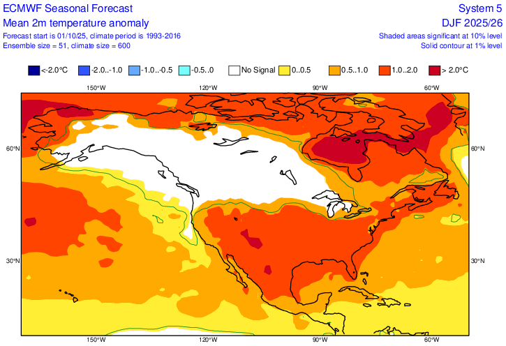
Updated Euro seasonal out today. DJF cooler than last run fwiw.

-
Updated Euro seasonal out. DJF cooler than last run fwiw.

-

Overnight Wednesday, November 5, 2025 Wind Event
CoastalWx replied to weatherwiz's topic in New England
It’s not fraudulent, but there’s a reason high end is on the rare side especially inland. -
It’s an honest assessment and not a fatalistic one. When the WPAC is at record levels of warmth in the IOD tropical MC areas and midlatitudes east of Japan and to south of the Aleutians, it introduces warmer risks to the forecast. Both for warm MJO phases and a steeper temperature gradient between Asia and the Pacific. These two features lead to frequent jet extensions which send mild Pacific air into North America. This is why the snowfall season is starting out at record lows for North America. We will need some type of help like we got back in January 2022 to both weaken the Pacific Jet and allow at least a brief return to some benchmark tracks for maybe a month. At this point in the season it’s always a wait and see.

-
Fall color is actually very good right now on the Clearview Expressway. it sounds late but it always peaks during the first week of November here.
-
"Looks" key word. Some people were calling for a record breaking hot October from "looking" at long range modeling. It also looked like October was going to be very dry and I would up with over 5 inches of precip.
-
Things look to get real interesting the end of the weekend around here. Will make a longer post this evening. Sent from my SM-G998U using Tapatalk

-
 Surprised its still a high wind watch and not a warning since we're less than 12 hours out ( other areas are under a wind advisory)
 -

Overnight Wednesday, November 5, 2025 Wind Event
Brian5671 replied to weatherwiz's topic in New England
Same story for 4 years really-the benchmark storm has become rare -

November 2025 general discussions and probable topic derailings ...
dryslot replied to Typhoon Tip's topic in New England
Unlike yesterday, Pretty calm so far in the woods wind wise this morning, Low was 28F as well.
-
Looks very warm for November
-

Overnight Wednesday, November 5, 2025 Wind Event
WxWatcher007 replied to weatherwiz's topic in New England
I still think this’ll be a fine event as 45-55mph inland is still quite solid, but high end is high end for a reason and we don’t really do high end in anything in SNE to begin with. San Diego east. -
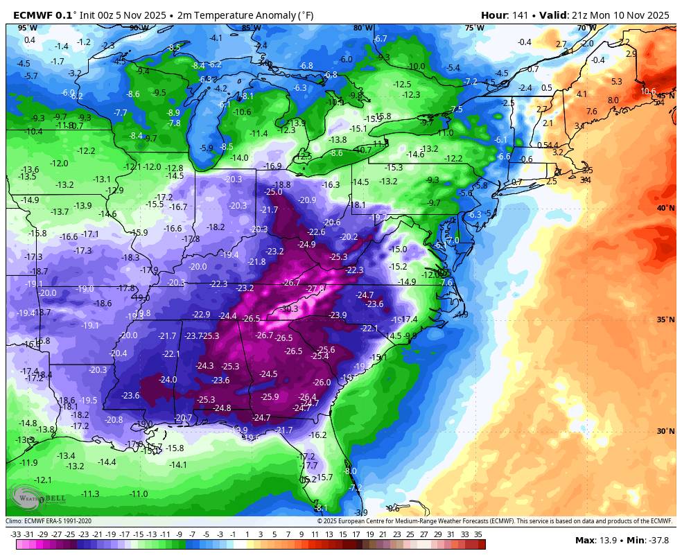
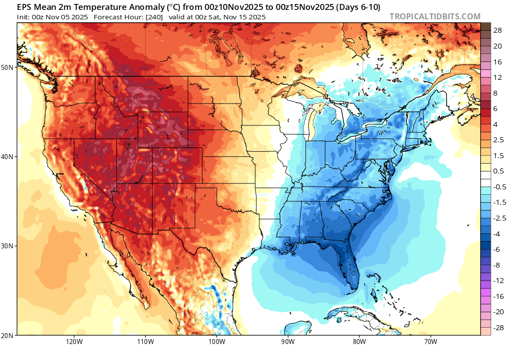
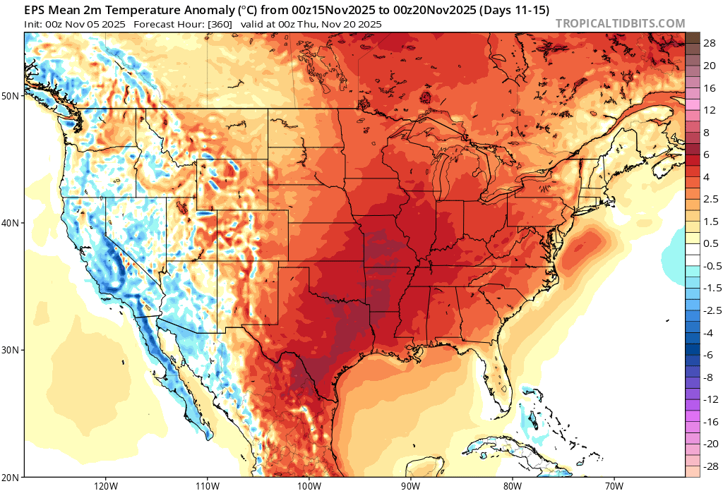
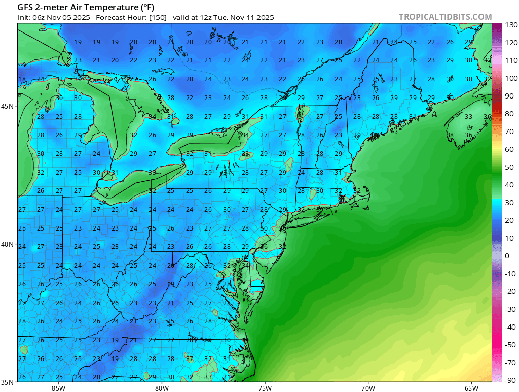
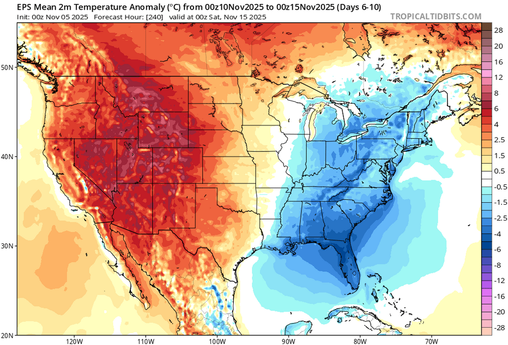
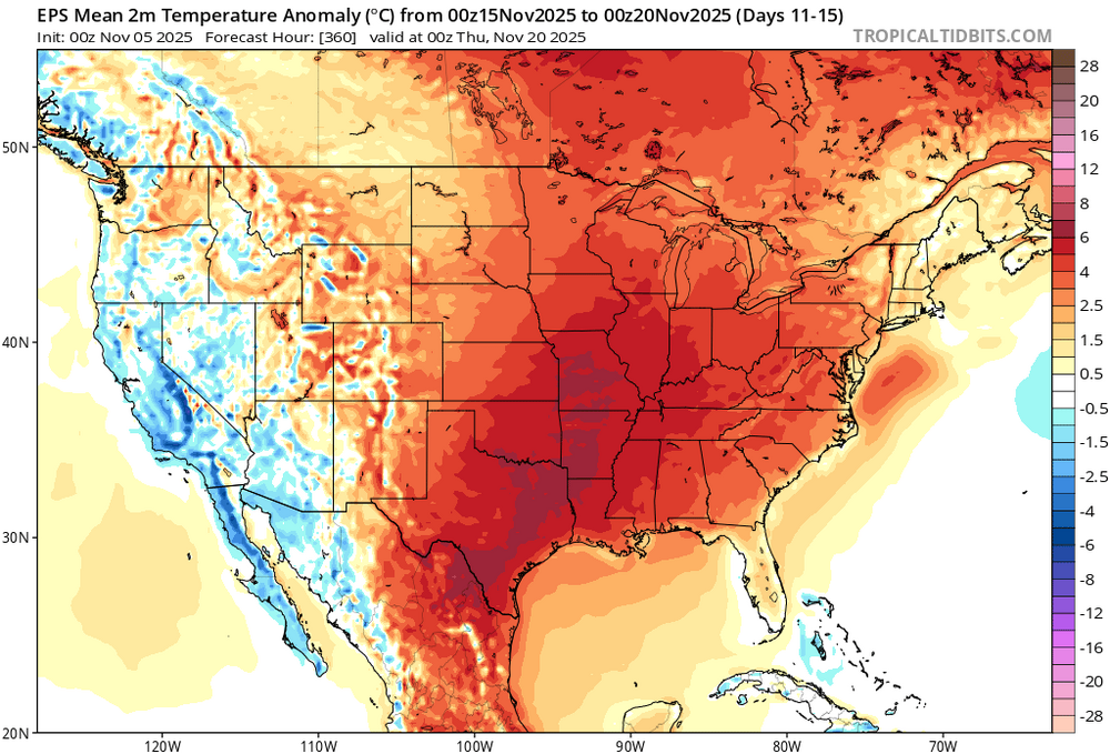
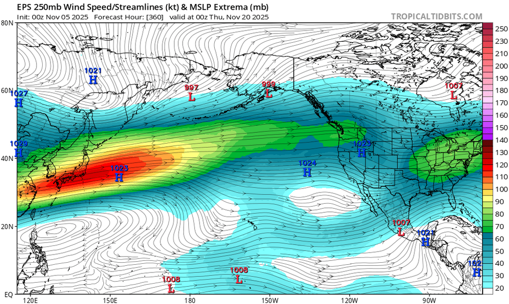
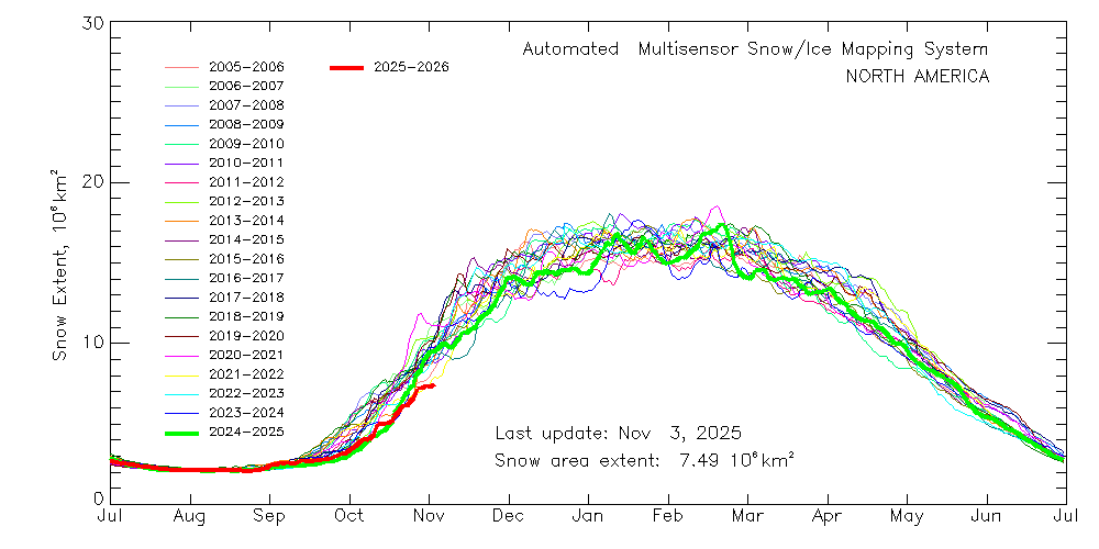
Very fast Pacific flow continues with storms racing through the Great Lakes. One of the storms next week will pull in a cooler airmass behind it lasting for several days. Doesn’t look too cold for this time of year as NYC may not be able to make it to freezing yet. Then a warm up after this as we rebound back to 60s and perhaps near 70° mid month. The Pacific Jet is so strong that ridge out West next week will eventually get pushed into the East after that. So a back and forth windy pattern. Most of North America will experience a milder Pacific influence. Snowcover for North America is starting the season at record low levels for this time of year.

-
Some thoughs on ENSO heading into next hurricane season: https://x.com/yconsor/status/1986046871349936133
-

2025-2026 ENSO
40/70 Benchmark replied to 40/70 Benchmark's topic in Weather Forecasting and Discussion
Take your pick form the last several lol I think the EPS was actually better with that? I thought GFS was worst and Australian was best. -
2025-2026 ENSO
40/70 Benchmark replied to 40/70 Benchmark's topic in Weather Forecasting and Discussion
I don't feel like there is any piece of data that you wouldn't be able to come up with a fatalistic take on. -
2025-2026 ENSO
40/70 Benchmark replied to 40/70 Benchmark's topic in Weather Forecasting and Discussion
The impact of the IOD is so nebulous...I feel like every attribution to that is voodoo. The only thing I hang my hat on is that it serves as a protective factor for the development of cool ENSO. -
2025-2026 ENSO
40/70 Benchmark replied to 40/70 Benchmark's topic in Weather Forecasting and Discussion
Second year Nina seasons don't necessarily have to be awful, though...71-72, 08-09... -
During the 70s, 80s, and 90s I rarely saw snow before Christmas. But my parents remember lots of snows in the 60s which were early. It certainly seems that early arriving winters are more normal now with February being less storm - kind of traded one for the other. Just a quick update so I don't have to post twice. The Euro continues to advertise a rather vigorous wave w/ the 9-11th cold shot. The GFS and CMC not so much. The Euro makes the most sense as that is a very common occurrence when cold are arrives which is that strong. Something to continue watching.
-
We had a forum prior to AmWx. It was basically the people from this site, but closed down. We were in the SE forum then. When we switched, the owners of this site graciously gave us our own forum. There are lots of storm threads in SE forum thread of the other site, even for our area. Eastern Weather I "think" was its name. I do think they archived it, but I am not sure where it is. It would be great to archive our stuff for the TN Valley and make it like a library. I am not sure how proprietary rights would work with that. But at least we would have a backup. Eastern just went off line one day, and never came back. Lost all of it.
-

Overnight Wednesday, November 5, 2025 Wind Event
WinterWolf replied to weatherwiz's topic in New England
Saw this coming…wind is a fraud 5 for the most part. Don’t really care…just know if it’s not tropical, expect an underwhelming event. It’s that simple. -

Central PA Fall Discussions and Obs
Mount Joy Snowman replied to ChescoWx's topic in Upstate New York/Pennsylvania
38 at the house and 34 through the rurals. Onward. -
Hopefully cutters for Thanksgiving and Christmas week ski season.
-
I am very excited for this winter. I do not except really any snow until the second half of December but strongly believe that January will be a burial.
-
November 2025 general discussions and probable topic derailings ...
CoastalWx replied to Typhoon Tip's topic in New England
Probably 45-55 there. Maybe a gust near 60 here.