All Activity
- Past hour
-
Pushing close to an inch here at work, we desperately needed all of this rain.
-
Not for nothing, but an interesting setup on the WF or perhaps triple point tomorrow morning near south coast.
-
This year has been the biggest test of my annual peak season forecast. We're a long way from grading and spiking any footballs, but I'm pleased with my call of a dead period like last year lasting until around 9/20, and activity being focused in the SW Atlantic. A huge part of my forecast can be verified by what happens in the next week or so.
-
Always bet on Fuijiwhara
-

2025-2026 ENSO
40/70 Benchmark replied to 40/70 Benchmark's topic in Weather Forecasting and Discussion
Interesting....some of my heavy-hitter analogs on that list. -
No, it wasn't...it was supposed to slightly more active than average.
-
Yeah, Elliott has been saying that today was going to be relatively dry followed by the best opportunity all week for rain overnight tonight into tomorrow.
-
This was supposed to be a very active season. Another blown long range outlook.
-
Finished with .33" of rain at home. Hoping everyone gets wet tomorrow.
-

Invest 94L—30% 2 day and 80% seven day odds of development
MJO812 replied to WxWatcher007's topic in Tropical Headquarters
Agree One will most likely be affecting the other one. -
This is the most useless tropical season that I can recall....yet to even acknowledge the season the on blog. Nothing to see here, either.....except the same 2 or 3 "doing it"....
-
.18" at home. In North Conway NH for the week. Beautiful area. Hit Mt Washington on Monday before the clouds rolled in. Breathtaking views.
-

September 2025 OBS-Discussion centered NYC subforum
psv88 replied to wdrag's topic in New York City Metro
0.05 -
 Agreed! The balancing act between systems will be fascinating to watch
 -

2025-2026 ENSO
donsutherland1 replied to 40/70 Benchmark's topic in Weather Forecasting and Discussion
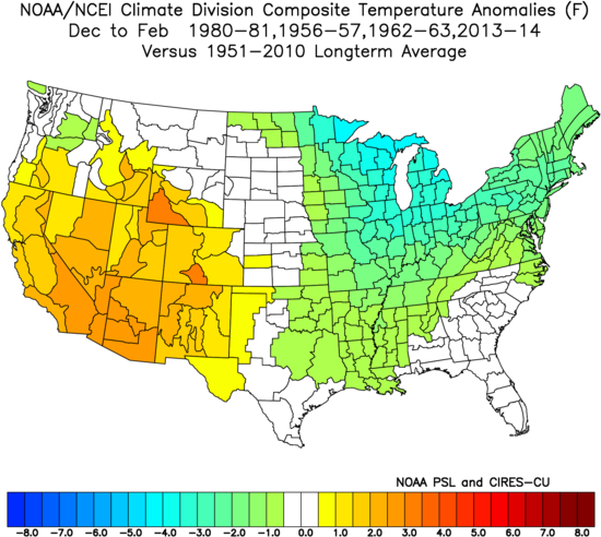
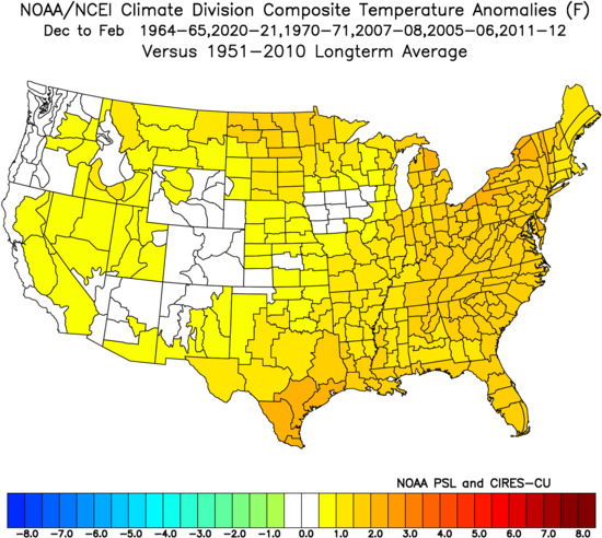
With respect to the EPO, the swing from the minimum value during the first half of September to the maximum value (so far) for the second half of September is the fourth largest on record. All of the prior 10 biggest such cases occurred during the evolution toward either La Niña or Neutral-Cool ENSO winters. The composite temperature anomalies for the Neutral-Cool ENSO Winters: The composite temperature anomalies for the Neutral-Cool ENSO Winters: However, warmth is not a slam dunk for the Northeast/Great Lakes. Winters 1964-65 and 1970-71 were cold in the Northeast, Great Lakes, and Northern Plains. Winters 2007-08 and 2020-2021 were cold in the Central Plains. Finally, the sample size is limited to 10 extreme EPO cases.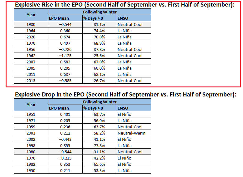
-
Let’s get RI’s rain total to match Dendy’s total since June.
-
Well, I guess this is good weather to get work done. Interesting to see DeepMind mentioned in the LWX disco. Neural nets and GenAI are legit…those computing resources, though.
-
 It does seem like a landfall is becoming somewhat unlikely for 94L because it gets pulled back out to sea by 93L. Meanwhile 93L is too far out to have a decent chance of being pulled into the coast by 94L. The most likely landfall scenario is a combination of 93L being weaker than expected and more spacing between the systems allowing 94L to be pulled into the coast by the ULL
 - Today
-
1-2” from wrn RI to New Bedford.
-

-
-
Recon might start sampling the environment today per NHC. This is a really complicated setup with the two systems so close. 00z EPS
-
It's been moving around
-
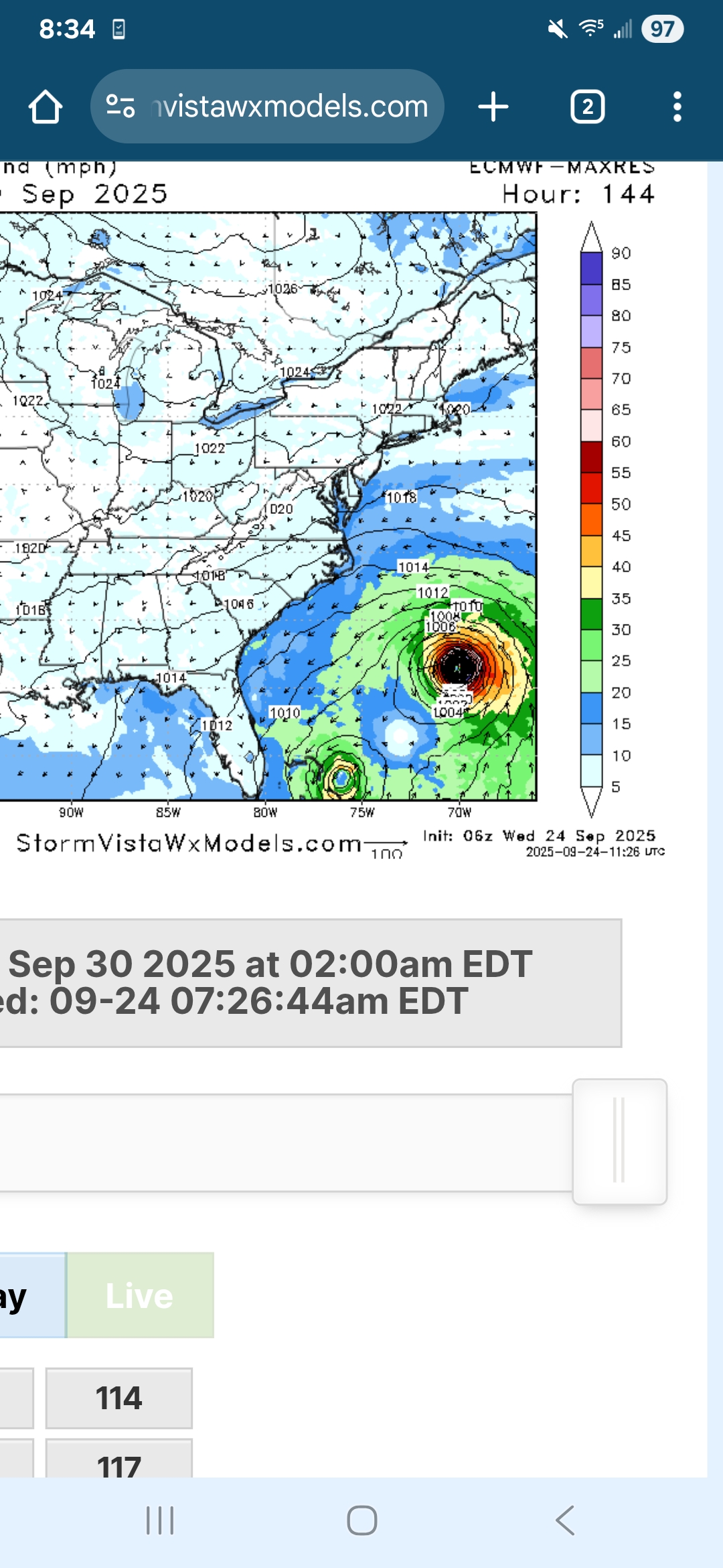
6z EURO is completely different from 0z.. hr 144 one is left in the Bahamas and the other is heading NW.. but would probably be eventually pushed out?
-
Man RI and the South coast is getting slammed right now..if we could just keep that heading north a little ways and we’d all get a good soaking!