All Activity
- Past hour
-
I was using the 30 year avg. Which is June 10th. The POR avg is June 18th.
-
Not at Detroit, it isn't. The long-term mean is June 18th. Three years saw 0 90+ days (1882, 1907 & 1915), and therefore aren't included in the analysis.
-
Ready to roast.
-
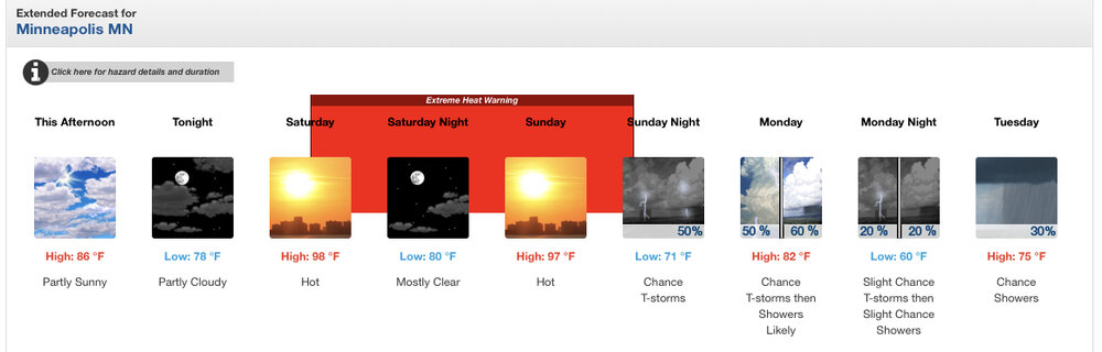
Funny you mention it, I was looking at bringing the family up to Duluth this weekend to escape the heat but it’s Grandma’s Marathon weekend so your assertion that half the state will be up there is probably accurate. Point forecast bumped up to 98 at MSP. Outside chance we break triple digits. The splash pad will be out in our yard this weekend and I’ll be trying to convince the kids to play in the basement.
-
Good. I don’t need 100 degree heat. Let the ocean cool us off while inland roasts
-
Overview of Wednesday's event across IWX: A line of strong to severe storms moved across the area in the afternoon and evening of Wednesday, June 18th, 2025. Overall, damage was generally confined to numerous instances of tree damage, scattered reports of power lines down, and some associated roof/siding damage to buildings/homes. Wind gusts were estimated to be between 50-60 mph. There were a few reports of quarter to golf ball size hail in northeast Indiana. The most extensive wind damage occurred in Van Wert County, OH; wind speeds of up to 70 mph downed an estimated 100 trees and caused minor damage to homes and buildings in the city of Van Wert. Van Wert County EMA director Rick McCoy said that this was the worst wind damage he had seen since the 2012 derecho. There were no injuries or fatalities. https://www.weather.gov/iwx/06182025_SevereWeather?fbclid=IwY2xjawLCqTRleHRuA2FlbQIxMABicmlkETBydHc3SEtscWREOFdOT1owAR7GZzaMMAguYLVWOFAczQU94f_75FcJfH_dNy9cL1It5yYarhFeMlsBMcNk1A_aem_ghpY_Dnre1a_h08Wrs5Clw
-
Lol, I remember you mentioning that earlier this winter I believe. The highway probably is probably situated in a low-lying area below the airport. I mean airports tend to be on somewhat higher ground for obvious reasons. I actually remember you mentioning that earlier. In the original post, you noted your car thermometer generally runs higher - which, of course, makes sense as, in most cases, heat would be radiating from the pavement/asphalt. But you know when there wouldn't be much heat flux? Hmm, probably near sunrise in midwinter. In fact, under optimal radiational cooling, the roadway surface would actually drop below the air temperature. You are comparing a thermistor, which certainly isn't as accurate as a platinum resistance thermometer, to begin with, that's housed about 1 foot off the ground to a 2M surface temperature. It doesn't surprise me under those conditions; it would read several degrees lower. It's sampling air way below the proper height and in a local "frost hollow" south of the airport. You do realize that, under optimal radiational cooling, there can be a substantial temperature inversion in the lowest several feet of the atmosphere above the ground, right? That's why it can be in the mid/upper 30s at 2M, but with frost laying on the ground.
-
 DCA: 104 IAD: 101 BWI: 102 RIC: 100
 -
Tomorrow will be the first 90 of the year for DTW. The avg first is June 10th.
-
I’m trying to determine what is the grossest part of the 18z parent NAM run, and I think it is the 108 Heat Index at 8pm on Monday.
-
18z NAM has a seabreeze for Monday as well. But it gets close to 100 before it drops us into the 80s and 70s east of the city.
-
Will be interesting to see the overnight lows. Someone posted in the NYC thread that the Euro had something ridiculous like 92/72 in NYC at 2am Mon night.
-
Happy longest day of the year. I wish tells followed that pattern and not the 2-3 month delay!
-
It will be interesting to see how many 90+ days we actually string together around here. Sat-Mon are a full on lock for 90+, but after that it gets tricky with the ROF potential. The Euro has been consistently keeping the streak alive all week, though, through Friday or so.
-
Tuesday and Wednesday are the days I'm favoring for 100 or better. If we get into the 100s as early as Monday then we're probably looking at a 2012 level heatwave.
-
Forecast high of 98 here on Monday. I'll take the under. 98 is the highest temp I have ever recorded here, and it was once or twice. It will end up 95-96 maybe.
-
i thought that this thread existed already, but apparently it does not. so, here we go...
-
NAM and HRRR are messy with the MCS. HRRR kind of carries activity into SNE through Sunday. That would cancel heat. NAM might argue for clouds. If that clears out in time, Sunday could be quite oppressive in the aftn. Some signs we have deep dews aloft with one of those setups that do not mix out much. Otherwise could be one of those mostly cloudy 85-90 days.
-
Yeah agree with Brian. Probably a lot of 98-99 with some spot 100s. Only thing that mighty argue for a 101 is that per GFS...we mix deeply and dews mix out. That might help offset the 850 Ts.
-
Nice and cloudy out there.
-
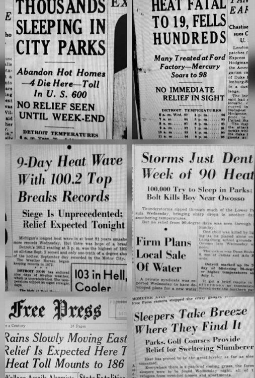
Heatwaves were just brutal in the 1930s-50s...with no AC
-

Occasional Thoughts on Climate Change
LibertyBell replied to donsutherland1's topic in Climate Change
but here in the northeast our air has become more humid and more cloudy, I compare years like 1944, 1948, 1949, 1953, 1955, 1966, when it was far easier to hit 100+ in drier air than it is now. Our cloudiness has increased since that earlier, much drier era. -
a couple of beaches on Long Island are closed because of elevated bacteria levels thanks to excessive rainfall and runoff from hazardous chemicals....
-
 but consider that forecasters do not like egg on their face so to speak... none of us like to be wrong. In this case confidence is high that problems will develop of the magnitude described. Yes watch is less confident than warning,