All Activity
- Past hour
-

2026-2027 El Nino
Stormchaserchuck1 replied to Stormchaserchuck1's topic in Weather Forecasting and Discussion
Sorry to dwell on the Winter West Coast ridge again, but this really stands out to me as an extreme anomaly Most extreme West Coast DJF ridge analogs The news is, the ridge really sticks around +time in analog cases.. this is the following year: March (not included in my visual analog picks.. yet almost as strong of an anomaly!) April (+60dm over the SW, US is extreme!) May Summer (June-August) Following Winter (26-27 analog) ^75% of the N. Hemisphere is +H5 in the following Winter, which fits a warming sequence possibly associated with El Nino. The main point is just the skew warm-general +time. This is the mid-latitudes the following Winter (26-27 analog) Winter PNA DJF 25-26 was negative, so interesting that they got a #1 record warm Winter on the West coast. Monthly PNA: -1.41 2026 0.79 -0.56 -

Pittsburgh/Western PA WINTER ‘25/‘26
SteelCity87 replied to Burghblizz's topic in Upstate New York/Pennsylvania
I always think of 2018 March storm. Second half of the month and we still managed 10.5" despite it all. One of my favorite storms. March 2011 was another but that was extremely heavy. Believe we got 8" or so in about 4 or 5 hours. -

E PA/NJ/DE Spring 2026 Obs/Discussion
Birds~69 replied to PhiEaglesfan712's topic in Philadelphia Region
Winters for me is around the days before Thanksgiving to well int March/early April. March April storms usually suck though... It was a B+ Winter at best so far. A+ it is not...., not even close to tell you the truth. -
Guess it’s the same down in SNE between ORH and everyone else around there. Dripping off rooftops at ORH but locked up tight elsewhere.
- Today
-
Talk about an inversion and fake cold preserving snowpack down low… 3,600ft… 29F 2,600ft… 36F 1,550ft… 39F (Ops building) 750ft… 21F (MVL and local PWS)
-

Texas 2026 Discussion/Observations
Stx_Thunder replied to Stx_Thunder's topic in Central/Western States
DFW radar storm totals up near 8" just southeast of the metro. Just in the past couple hours. Still looks very convectively interesting heading into the weekend and early next week with a meandering front and cutoff Low setting up out west over Baja region. Ensembles starting to trend on a faster, but stronger/deeper track into the state. -
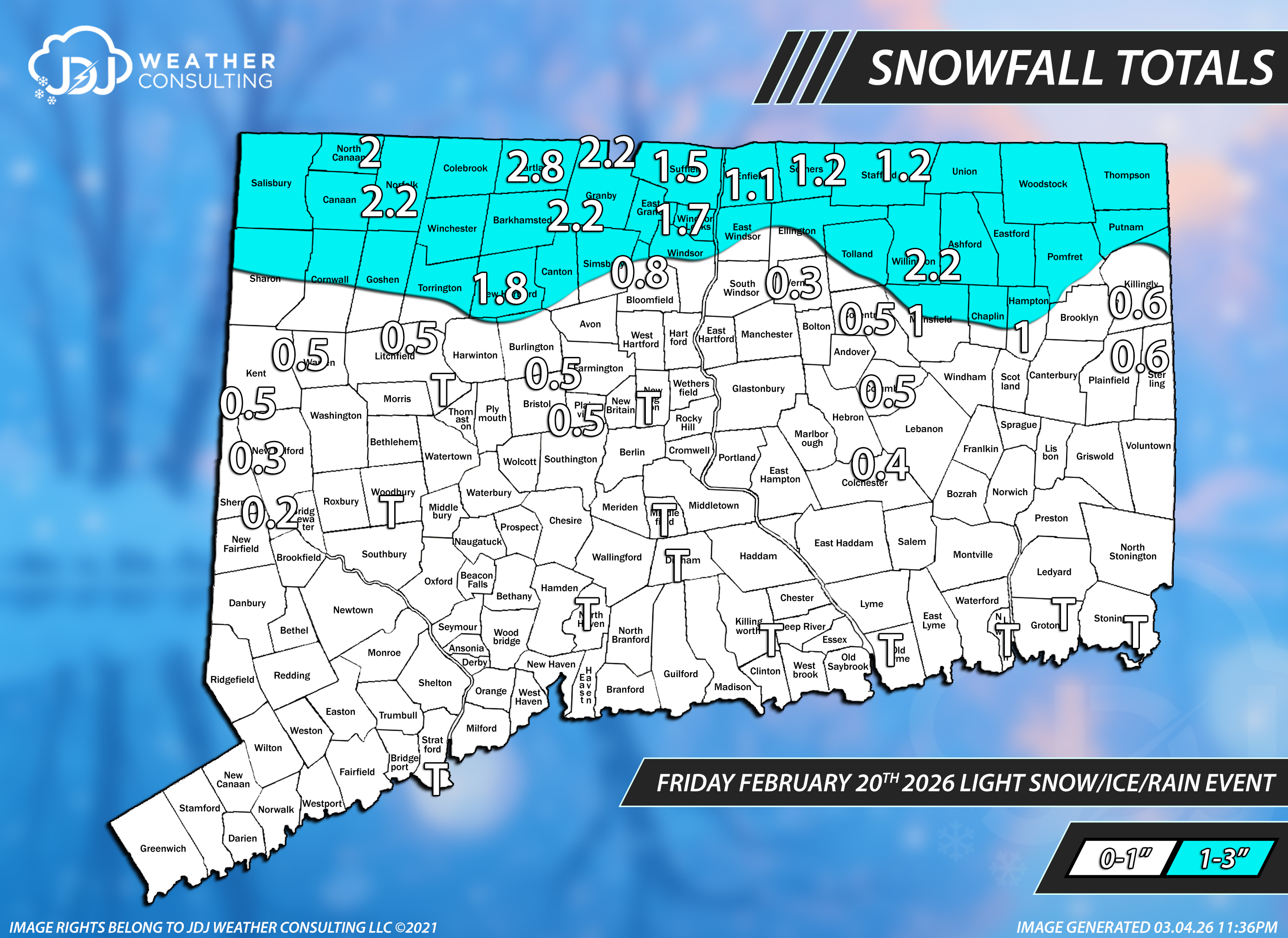
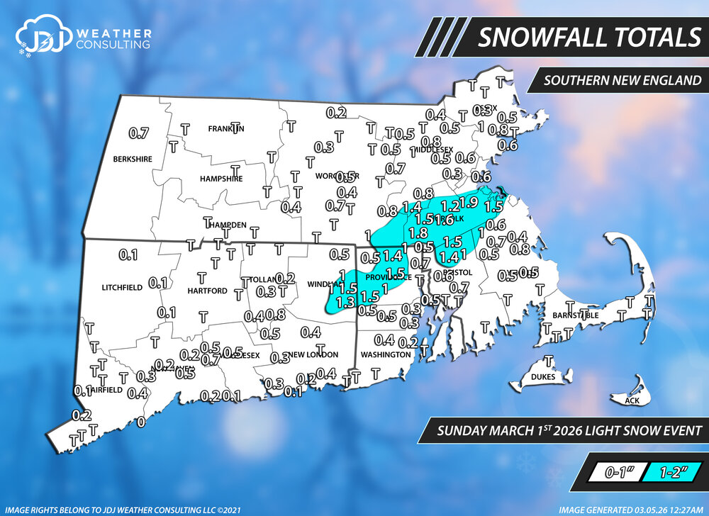
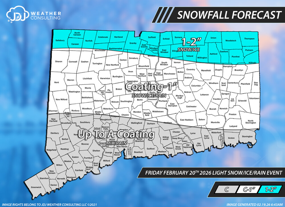
Snowfall totals from this light snow event. Went C-2 statewide, probably could have easily done C-1 and it would have been better with just a couple reports around Killingly area over 1".
-
Looks like the dry pattern is actually dying with the Niña this time.
-
Ice ice baby. Maybe a morning surprise for some people?
-
BDCF / CAD wedges are one of the few areas in which I'd take the NAM over the Euro. Early March is peak BDCF Wedge season.
-
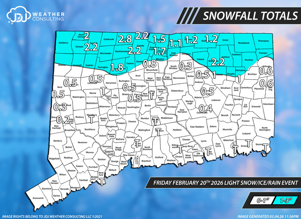
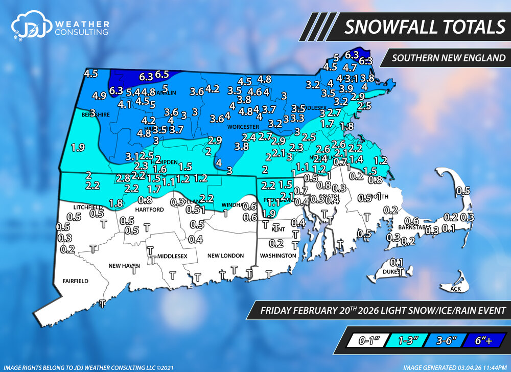
Working my way backward, finally finished this slop event. It's been hard to keep up with all these C-3 type events. Forecast for this was pretty much excellent for CT. A- Oh and the BOX PNS is pretty hilarious. TWO ORH reports included and both of them are wrong . The final for ORH was 2.4
-
well I’m doing my best not to bury my sled off-trail, so I’m not really sure but based on past experience, it’s deep, prob close to 3’. Saw a moose up that way up to its chest in the middle of a clearing.
-
0z GFS with a 80F sounding for DC March 11. NWS has it anyway Tuesday Sunny, with a high near 80. Tuesday Night Partly cloudy, with a low around 64. Wednesday Partly sunny, with a high near 79
-
Not really, recently all of our cold/snowy winters seem to be consecutive: 2002-03, 2003-04, 2004-05; 2008-09, 2009-10, 2010-11; and 2013-14, 2014-15.
-

E PA/NJ/DE Spring 2026 Obs/Discussion
PhiEaglesfan712 replied to PhiEaglesfan712's topic in Philadelphia Region
Yeah, you need a lot of cold air in place. In the years when we had big snowstorms post-March 15 (1956, 1958, 2018, etc.) there were many days with below average temperatures (mostly in the 40s and even 30s, as well as at least one snow event) leading up to it: 1956-03-06 47 38 42.5 2.1 22 0 0.06 0.0 0 1956-03-07 51 38 44.5 3.8 20 0 0.13 0.0 0 1956-03-08 45 31 38.0 -3.0 27 0 0.50 T 0 1956-03-09 49 30 39.5 -1.8 25 0 0.00 0.0 0 1956-03-10 56 34 45.0 3.4 20 0 0.00 0.0 0 1956-03-11 59 40 49.5 7.6 15 0 0.06 0.0 0 1956-03-12 48 33 40.5 -1.7 24 0 0.09 T 0 1956-03-13 38 32 35.0 -7.5 30 0 0.09 0.7 T 1956-03-14 48 37 42.5 -0.3 22 0 1.56 0.0 0 1956-03-15 42 34 38.0 -5.1 27 0 0.00 0.0 0 1956-03-16 36 26 31.0 -12.4 34 0 0.73 1.3 T 1956-03-17 33 23 28.0 -15.7 37 0 T T 1 1956-03-18 30 25 27.5 -16.5 37 0 0.56 5.4 0 1956-03-19 30 23 26.5 -17.8 38 0 0.35 3.3 7 1958-03-01 46 39 42.5 3.4 22 0 0.00 0.0 0 1958-03-02 53 34 43.5 4.1 21 0 0.00 0.0 0 1958-03-03 49 38 43.5 3.9 21 0 0.17 0.0 0 1958-03-04 46 34 40.0 0.1 25 0 0.00 0.0 0 1958-03-05 47 34 40.5 0.3 24 0 0.00 0.0 0 1958-03-06 50 30 40.0 -0.4 25 0 0.00 0.0 0 1958-03-07 49 35 42.0 1.3 23 0 0.00 0.0 0 1958-03-08 46 31 38.5 -2.5 26 0 0.00 0.0 0 1958-03-09 40 28 34.0 -7.3 31 0 0.00 0.0 0 1958-03-10 53 34 43.5 1.9 21 0 T T 0 1958-03-11 54 31 42.5 0.6 22 0 0.00 0.0 0 1958-03-12 45 35 40.0 -2.2 25 0 0.00 0.0 0 1958-03-13 42 29 35.5 -7.0 29 0 0.39 1.4 1 1958-03-14 39 32 35.5 -7.3 29 0 0.66 0.6 2 1958-03-15 44 36 40.0 -3.1 25 0 0.00 0.0 T 1958-03-16 42 33 37.5 -5.9 27 0 0.00 0.0 0 1958-03-17 44 31 37.5 -6.2 27 0 0.00 0.0 0 1958-03-18 48 31 39.5 -4.5 25 0 T 0.0 0 1958-03-19 38 33 35.5 -8.8 29 0 0.81 1.4 0 1958-03-20 35 32 33.5 -11.2 31 0 1.76 9.6 4 2018-03-02 45 32 38.5 -0.9 26 0 0.86 1.5 0 2018-03-03 46 35 40.5 0.9 24 0 T T 1 2018-03-04 48 31 39.5 -0.4 25 0 0.00 0.0 0 2018-03-05 47 30 38.5 -1.7 26 0 0.00 0.0 0 2018-03-06 48 29 38.5 -1.9 26 0 0.23 0.1 0 2018-03-07 36 32 34.0 -6.7 31 0 1.28 6.0 T 2018-03-08 40 31 35.5 -5.5 29 0 0.00 0.0 4 2018-03-09 42 30 36.0 -5.3 29 0 0.00 0.0 3 2018-03-10 44 29 36.5 -5.1 28 0 0.00 0.0 2 2018-03-11 46 28 37.0 -4.9 28 0 0.00 0.0 1 2018-03-12 43 29 36.0 -6.2 29 0 0.06 T 0 2018-03-13 42 32 37.0 -5.5 28 0 0.03 T T 2018-03-14 41 29 35.0 -7.8 30 0 0.00 0.0 0 2018-03-15 46 32 39.0 -4.1 26 0 T 0.0 0 2018-03-16 42 31 36.5 -6.9 28 0 T T 0 2018-03-17 48 28 38.0 -5.7 27 0 0.00 0.0 0 2018-03-18 50 31 40.5 -3.5 24 0 0.00 0.0 0 2018-03-19 52 33 42.5 -1.8 22 0 0.00 0.0 0 2018-03-20 35 29 32.0 -12.7 33 0 0.40 0.9 0 2018-03-21 36 31 33.5 -11.5 31 0 1.06 6.7 1 We just don't have that coming up this year. We have temps forecasted in the 60s and 70s. I have a feeling anyone holding out hope for more snow is going to end up disappointed. -
Magic ball ?
-
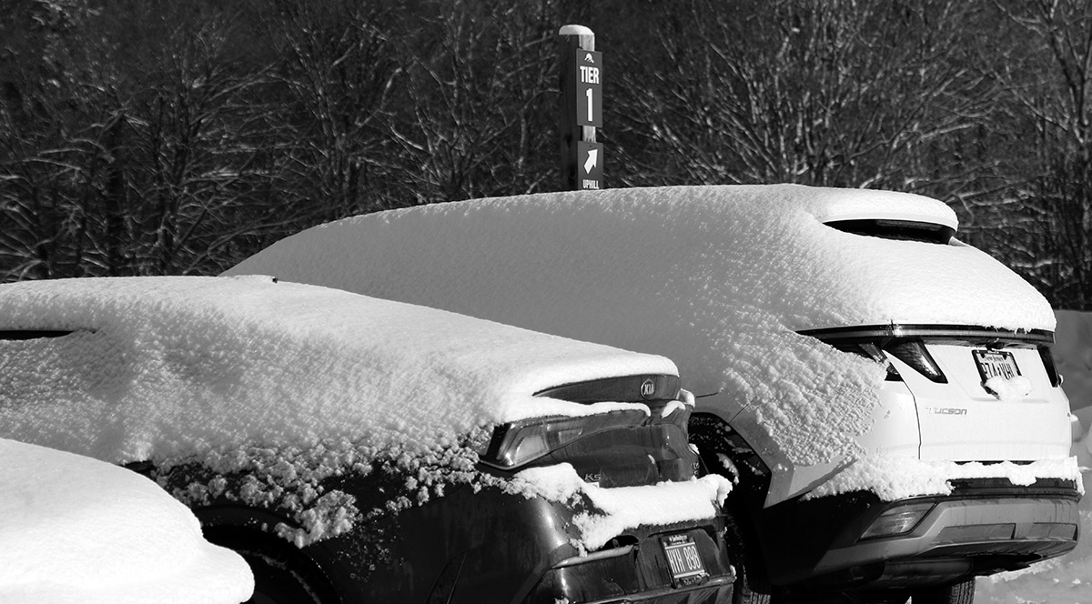
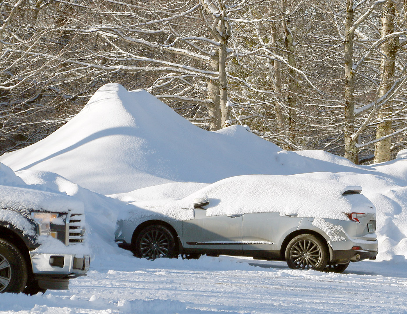
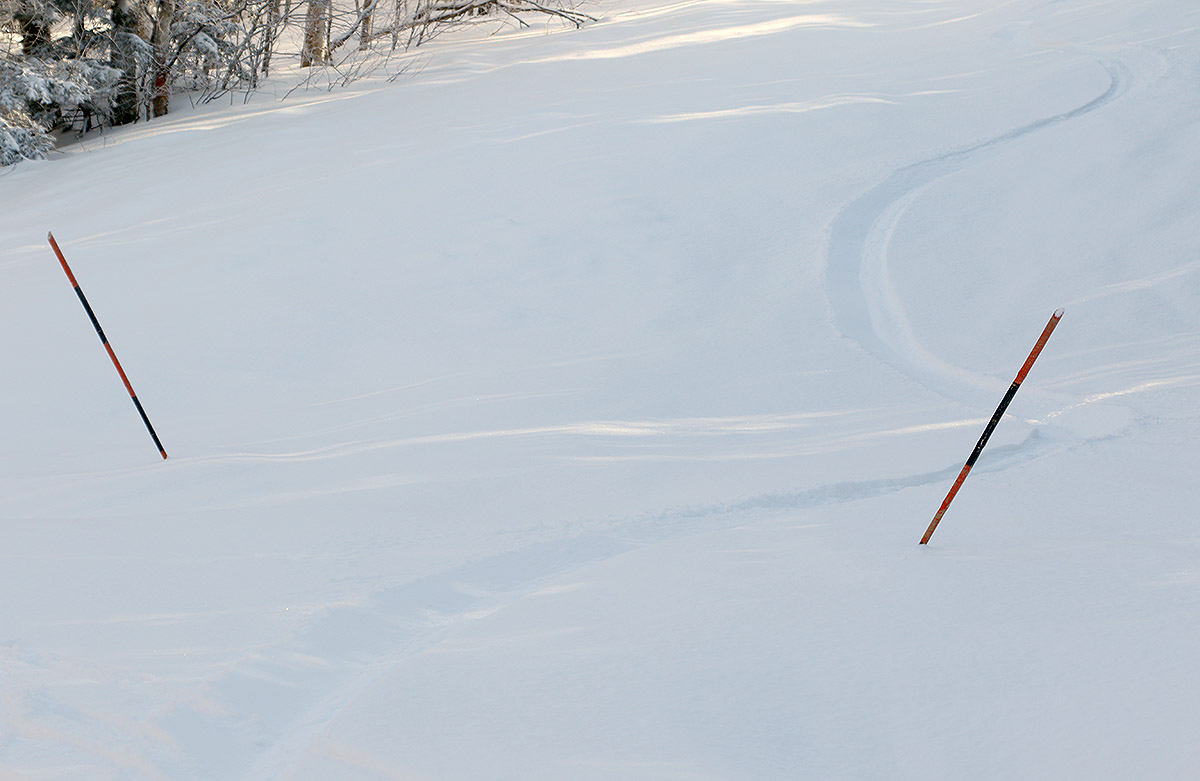
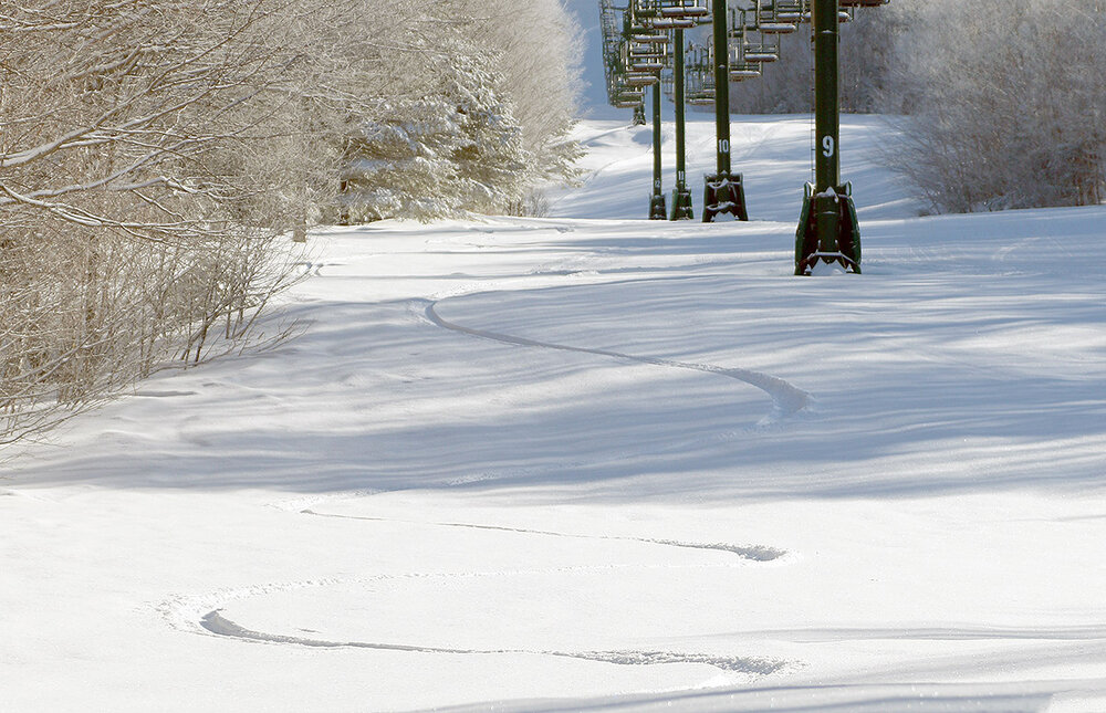
Last night’s system delivered 3-4” of new snow here in the valley, so I headed up to the mountain this morning to get in a tour and check out the conditions. There really wasn’t much difference in accumulations with respect to elevation – Bolton Valley was also reporting 3-4” new, and that’s what I measured throughout my tour in the 2,000’ to 2,700’ elevation range via the Wilderness Uphill Route. The 3-4” of snow contained about ¼” of liquid equivalent, so the snow was certainly powdery (~7% H2O), but not ultra-light, so it had enough substance to be supportive on low and moderate-angle terrain. Turns weren’t 100% bottomless on that amount of liquid equivalent, but many turns were off the bottom, and the subsurface was surprisingly soft as well, so the turns were excellent all around. While the new snow was great, the weather itself was also quite impressive – there was bright sunshine, no wind, and temperatures in the upper 20s F. That March sun warmed you instantly, and it was the type of weather you wish you could get on every outing, perhaps only falling short of those days with 1-2”/hr. snows that literally freshen your tracks every run.

-
Seems like the mild next week should cause some things to pop.
-
you want snow all of a sudden?
-
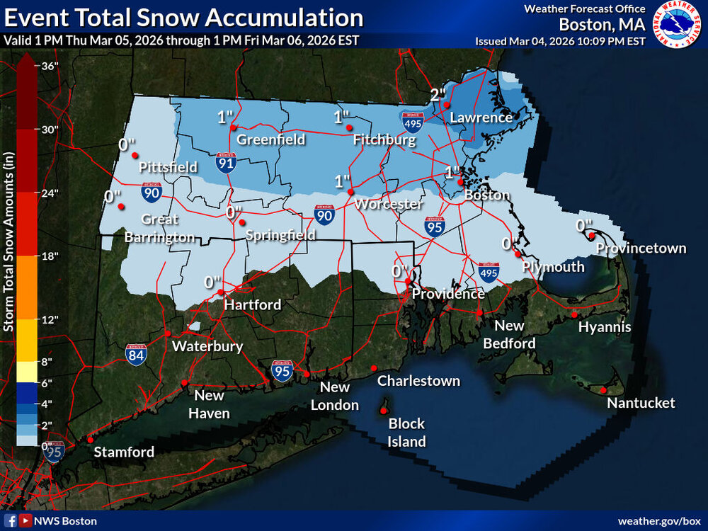
I haven't looked at this closely at all but from what ive seen it doesn't seem conservative at all to me, if anything its bullish on the snow. I dont see this producing any accumulating snow south of 90 Not saying this NWS map is right or what id go with, just compared to what little ive looked at this and whats out there its on the higher end snowfall wise.
-
all salemen/ladies asleep
-
8-10?
-
I could def. see 4-8"...agree my map is conservative, but I just don't trust the higher QPF output yet....maybe tomorrow night I patch 4-8" over the 3-6".
-
Euro still saying the opposite, let’s hope it’s right.
-
12"? No. Maybe like 4-8"....