All Activity
- Past hour
-

Central PA Winter 25/26 Discussion and Obs
Jns2183 replied to MAG5035's topic in Upstate New York/Pennsylvania
That's why we have ensembles. The normal run is just one member in a mix of like 50. You ever see a printout of all the members and how wildly different they are? All that difference is due to miniscule changes at the start in each if the results. Weather is the ultimate complex stochastic, non-deterministic system. Even though it is based on deterministic physical laws. One would need to know the position and momentum of all molecules that make up the earth and it's atmosphere at the starting condition in order to attain perfect models. One reason models go from blizzard to flurries is it's a whole lot harder to have things happen in the precise order and precise timing but the answer to your question is not to ever relay on a single model run of a single model. Blended forecasts based on multiple models and model runs are the rule for a reason. Sent from my SM-S731U using Tapatalk -
No but I bet it’s further north than most think
-
Prob too aggressive
-
Merry Christmas!! I really hope so Jax. Once we get into January, clock is ticking for sho!
-
Only goes out to 21 hours
-
NAM shows sleet to Albany. You buying that?
-
Agree but the NAM showing what it does doesn't mean it's right either especially when it's own 3k disagrees.
-
My nephew got a new puppy and my Christmas present is that Chip has chosen my lap to nap. Merry Christmas!
-
We go through this every year the Nam is good at showing the mix line which always ends up further north in the end alot of denial out there
-

Boxing Night Snow/Sleet/Ice Dec 26-27 Storm Thread/Obs.
LVblizzard replied to Mikeymac5306's topic in Philadelphia Region
If you buy how dry the NAMs are…I personally don’t. Sleet ratios are typically around 3:1 and I think we get at least an inch of pure sleet, along with up to an inch of snow. -
An identical 72.8 as yesterday. At least it’s fun to get the kids outside playing with their presents
-

26th-27th event, coming at us like a wounded duck.
ORH_wxman replied to Go Kart Mozart's topic in New England
This is gonna be a crazy battle between the mid and upper level support for heavy snow and the obscene dry arctic air to the northeast. I’m looking at several different models right now and almost all of them are punching some serious lift, fronto, and dPVA well into SNE, but the further northeast you go, it just fights that ridiculous low level arctic air. There’s gonna be crazy Virga on the northeast side. Prob the type of system where you have Virga under 15-20 dbz returns. -

Boxing Night Snow/Sleet/Ice Dec 26-27 Storm Thread/Obs.
Duca892 replied to Mikeymac5306's topic in Philadelphia Region
These trending to being just a meh nuisance is so disappointing -
Come on the best has shifted north
-
This is the only type of scenario where I don't dismiss the NAM
-
do you have the snowmap
-
Rooting for nyc to cash in so then we can all win come January.
-

26th-27th event, coming at us like a wounded duck.
Sey-Mour Snow replied to Go Kart Mozart's topic in New England
Ha I figured you’d enjoy that more -

Central PA Winter 25/26 Discussion and Obs
canderson replied to MAG5035's topic in Upstate New York/Pennsylvania
I’ve had quite a bit of red wine but not that much (yet)! -
What?
-
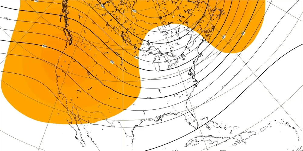
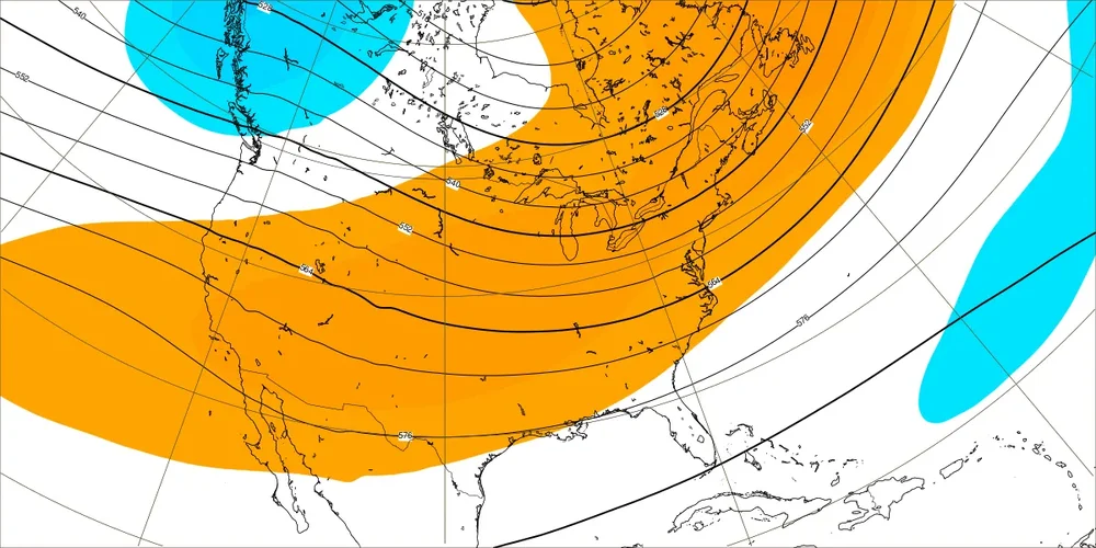
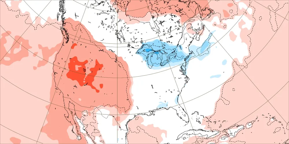
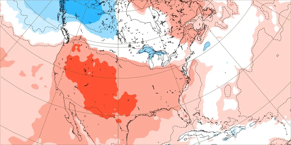
The best looking H5 map for cold potential for the E US Jan on today’s Euro Weeklies is this one with a nice +PNA, which is for 1/12-18 (similar to yesterday): Just 3 days ago it still had an ugly -PNA: so there’s been a big change for an ens mean Here’s today’s temp map for the same week (similar to yesterday): chilly but I fully expect this would turn much colder than this if the +PNA idea is right Here’s what the same week’s map had just 3 days ago, which is consistent with that ugly H5 then:
-

Boxing Night Snow/Sleet/Ice Dec 26-27 Storm Thread/Obs.
RU848789 replied to Mikeymac5306's topic in Philadelphia Region
NWS finally updated their map, below, which shows Metuchen just about on the 6" line which kind of is within the 3-5" range for us in the advisory, but is also within the 4-8" range on my point and click. This snowfall map also makes sense with the warnings for ~6" for Morris/Warren and Sussex. They really need to issue their updates across all products at the same time or close to it, not over 2+ hours (their advisories/warnings were issued around 1 pm). -

26th-27th event, coming at us like a wounded duck.
40/70 Benchmark replied to Go Kart Mozart's topic in New England
It wasn't funny at first, but the 40/70 % addition changed that -
It's a shame the RAP has a known cold bias, because this would be incredible.
.thumb.png.7a57b6ac6e77f2e4fb62ed1e3306ad39.png)
-
NWS finally updated their map, below, which shows Metuchen just about on the 6" line which kind of is within the 3-5" range for us in the advisory, but is also within the 4-8" range on my point and click. This snowfall map also makes sense with the warnings for ~6" for Morris/Warren and Sussex. They really need to issue their updates across all products at the same time or close to it, not over 2+ hours (their advisories/warnings were issued around 1 pm).


.png.436ca81fe81eedf828da27243fe2d788.png)