
All Activity
- Past hour
-
Small cyclone, nuclear grade water temps, BOC, divergent flow. This is going to explode today. Think even the aggressive models are undershooting intensity. Do not think this landfalls near peak intensity but next 24 hours I expect this to become a high end cane I’ve seen this look before in the gulf…
-
Mins…MHT is still having issues, but looks like they were around 34°
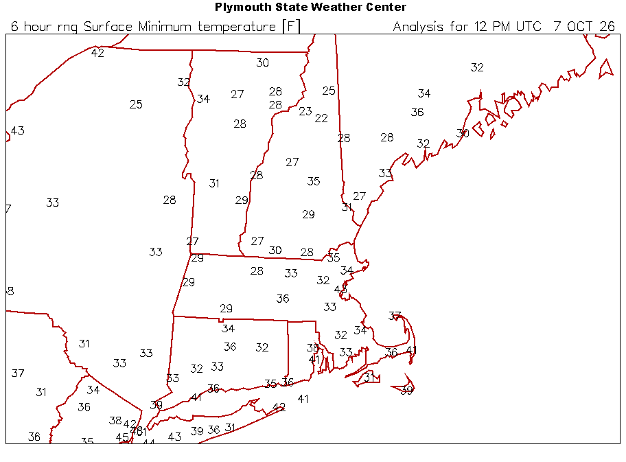
-
37 degrees and foggy this morning.
-
I know there are a few other college football fans here, what do they do with the Georgia Bama game Saturday night? And Gameday for that matter. I would think today (maybe tomorrow?) they have to decide if they do anything.
-
First frost of the season here on the cartops with a low of 36°. https://www.weather.gov/wrh/timeseries?site=khvn
-
37 for the low here with frost on the rooftops
-
-
What is the best link for the deep mind ensemble suite? Ugh...I didn't want to, as I'm about to jump into winter outlook mode, but the tropics call. Man, I'm sick-
-
It probably came on 3-4 times overnight and about 3-4 times in the 3 hours I've been up. I don't think its very well insulated. It gets crazy hot in here once it gets above like 65-70, especially the bedroom and super chilly in the winter. Also, doesn't help that the ACs are still in the living room/bedroom window. I think both have massive spider webs and spiders attached to them so I can't take them out until they go
-
Regardless what happens on approach this thing is going to go boom today. That’s a heck of a satellite presentation this morning
-
Bottomed out this morning at 43.9 this morning in Queens...lowest in a long while and quite a bit lower than what was recorded at LGA.
-
All night? What are you elderly?
-
45. Two degrees warmer than yesterday
-
Frosty morning, heat kicking on all night. BOOOOOOOOOOOOOOOOOOOOOOO
-
How much frost on those eyebrows? Holy shit.
-
some frost on the rooftops here-down to 37 but recovering quickly now with the sunrise
-
Ice on ponds?
-
I remember, not only for the strong southerly wind as it passed to our west but that wind brought the ocean spray so far inland and killed the foliage on many of the south facing side of the trees.
-
I was thinking last night that the correction vector is usually east with a poleward moving tropical cyclones and an approaching front.
-
The names only get retired if they cause significant enough effects. While the first Isaias gave me my strongest wind gusts to 78 mph back in SW Suffolk, it didn’t produce wide enough damage as a weaker hurricane and then tropical storm to have the name retired. Many big majors get retired along with weaker systems which produce historic rainfall.
-
39 here. Heat kicked on for the first time when the house hit 65
-
Names repeat every 6 years unless retired.
-
Looks like we're going to have quite a battle of timing and walking thin ice with that shear axis. Might be a back and forth between 6 hr runs on the TC model suites today until they get a better feel for track motion, and if/when the mid-level shear begins encroaching. For example, the 18z HAFS suites kept intensity in check, preventing a major. The 00z suites kept the core on the edge and bombed Isaias into a strong major. The recent 06z runs are back to allowing encroachment in the mid-levels again, though it may still be reaching Category 3 / 960s prior to weakening. We'll have to see if the 12z suite swing back to flirting with the 940s and a more significant major.
-
35 my low. We survived. It is 63 in the apartment and will not put on heat
-
39.8 in Syosset & 38.9 in Muttontown for the morning low.



















