All Activity
- Past hour
-

2025 Atlantic Hurricane Season
BarryStantonGBP replied to BarryStantonGBP's topic in Tropical Headquarters
-
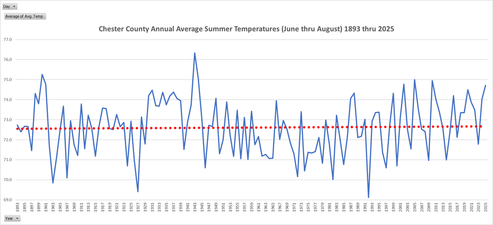
Despite a well below normal August in temperatures overall summer (June thru August) finished as our warmest summer since 2010. But still well below our warmest summer way back in 1943. Overall there has been clearly almost no warming at all across our summers since 1893. A very flat trend line is clear to see! The below analysis is across 31 NWS/FAA/DEOS/COOP and trained spotter data since 1893.
-

E PA/NJ/DE Summer 2025 Obs/Discussion
ChescoWx replied to Hurricane Agnes's topic in Philadelphia Region
Despite a well below normal August in temperatures overall summer (June thru August) finished as our warmest summer since 2010. But still well below our warmest summer way back in 1943. Overall there has been clearly almost no warming at all across our summers since 1893. A very flat trend line is clear to see! The below analysis is across 31 NWS/FAA/DEOS/COOP and trained spotter data since 1893.
-
I checked - all 5 brought 100"+ here and averaged 130% of the 27-winter mean.
-
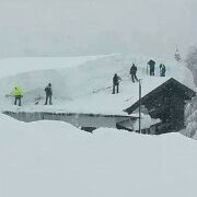
Bet it was awesome! Hope you got some good pics! .
-
@snowman19 I think you'll like this. Great solar presentation.
-
Imby August total rainfall: 0.16”
-

September 2025 OBS-Discussion centered NYC subforum
donsutherland1 replied to wdrag's topic in New York City Metro
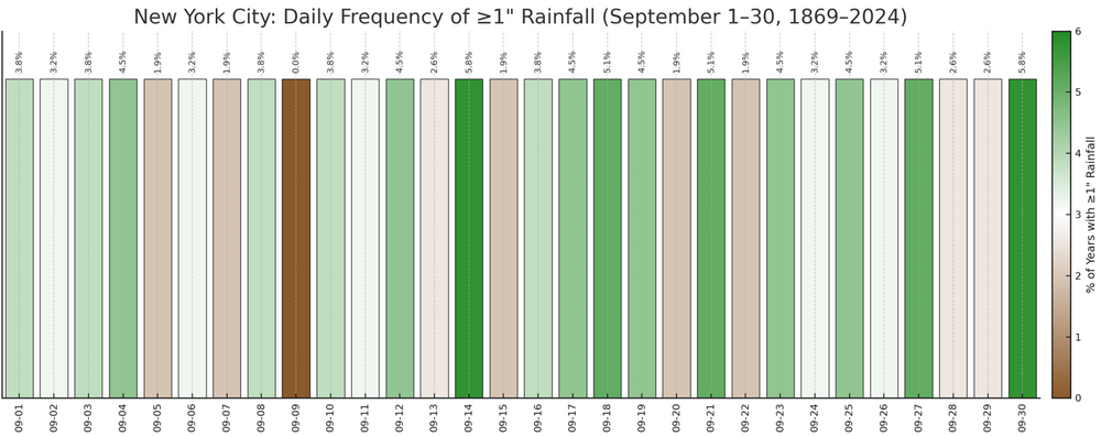
Frequency of Measurable Daily Rainfall in September for NYC: Frequency of 1.00" or More Daily Rainfall in September for NYC: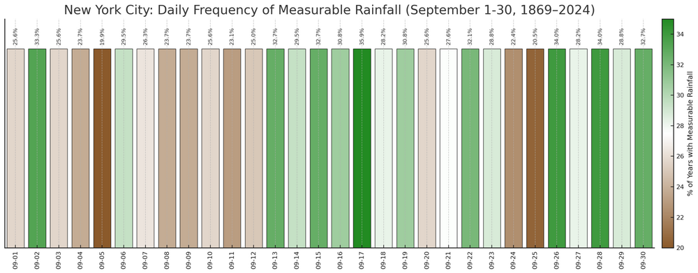
-
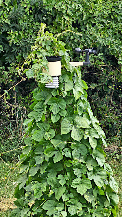
Sometimes a little attention is required to your WX station.
-
Friday rain really backing off across SNE. Stein really digging in now
-
Especially because it took a minute to settle in too. Memorial Day weekend was freezing. It was a short, hot, humid summer.
-
NWS really missed that last storm BAD. It just vanished. However, it enabled me to deliver last night, had a very very good night so happy it did not rain. Holiday weekends are the BEST! Here comes the Holiday Season! Nothing but 90s/70s dewpoints for the foreseeable future! Rain be GONE! Wall to wall perpetual sunshine here forever in The Lone Star State! Fall is still a good ways away from us! If you live in the DCA Metropolitan Region......... Better look out! Gonnabe super COLD! Lots chances for moisture/frigid airmass alignment! Gonnabe a MASSIVE winter for snow lovers back East! You can take that directly to the Bank with 98 percent interest which YOU get to keep!
-
September 2025 OBS-Discussion centered NYC subforum
donsutherland1 replied to wdrag's topic in New York City Metro
Many parts of the region have seen among their ten driest water years (September 1-August 31) periods: Islip: 33.71" (9th driest) New York City-JFK Airport: 30.71" (6th driest) New York City-LaGuardia Airport: 32.90" (8th driest) White Plains: 33.47" (6th driest) Newark just missed. Its 31.79" ranked as the 11th driest water year. Note: Bridgeport is missing rainfall data, so it was excluded from the list. However, if one added 1"-2" of additional precipitation, its water year would rank between 4th and 6th driest on record. -
Went camping at Roan Mountain SP this weekend. Phenomenal weather other than a passing shower or two yesterday evening. This is great! .
-
September 2025 OBS-Discussion centered NYC subforum
donsutherland1 replied to wdrag's topic in New York City Metro
August 2007 closed without any rainfall during the last 10 days of the month, as was the case this year. September 1, 2007 opened up with a high of 79° and low of 64°; September 2025 began with a high of 78° and a low of 64°. September 2007 would go on to wind up warmer than normal with a mean temperature of 70.3° and drier than normal with monthly rainfall of just 1.81". Before one concludes that 2025 has a near identical twin, even if the outcome winds up similar over all, 2007 went on to see a strong La Niña develop following a preceding El Niño winter. The important point is that there are no "perfect" analogs so to speak. However, one needs larger samples. For example, the idea of a drier than normal September is based on 10 cases with no rainfall during August 22-31. It's just one piece of evidence. That the CFSv2 has swung from a wet to a dry idea increases confidence in that outcome. Should the forthcoming ECMWF monthly data reaffirm the earlier idea of a drier than normal September in the Northeast, confidence would increase further. Of course, the Tropics could always hurl a curve ball, perhaps later this month, that foils such forecasts. For now, with a quiet pattern expected to prevail through the near-term, one can look at some fun coincidences like the one mentioned for 2007. Generally cool and dry conditions will persist through midweek. Highs will generally top out in the upper 70s with lows in the 50s outside New York City and low 60s in New York City. It could turn somewhat warmer late in the week with highs on Thursday through Saturday approaching or reach the lower 80s before another cooler air mass moves into the region. A system could bring some rain on Friday into perhaps Saturday. Rainfall amounts appear likely to be mainly less than 0.50". The ENSO Region 1+2 anomaly was -0.1°C and the Region 3.4 anomaly was -0.4°C for the week centered around August 20. For the past six weeks, the ENSO Region 1+2 anomaly has averaged +0.45°C and the ENSO Region 3.4 anomaly has averaged -0.28°C. Neutral ENSO conditions will likely continue into early autumn. The SOI was -5.23 today. The preliminary Arctic Oscillation (AO) was -0.084 today. -
1. Euro ens clearly favors safe recurve from US but Erin did end up ~200 miles NW of early projections fwiw and some members hit or are close to E coast. 2. Those Caribbean members aren’t directly relevant to this thread about the E MDR AEW and I have little feel for it now, regardless. Also, Sep 13th is still a bit early for CAG. But it’s possible given this persistent E US trough pattern.
-

September 2025 OBS-Discussion centered NYC subforum
doncat replied to wdrag's topic in New York City Metro
Yeah can't remember a dry pattern like this in a long time ...now been going on for a year with my station receiving 31.65" rain in the past 12 months which is a 17" deficit! -
2025 Atlantic Hurricane Season
BarryStantonGBP replied to BarryStantonGBP's topic in Tropical Headquarters
Gfs is a meme go with euro -
Persistent southerly flow. Did feel a bit dewy too.
-
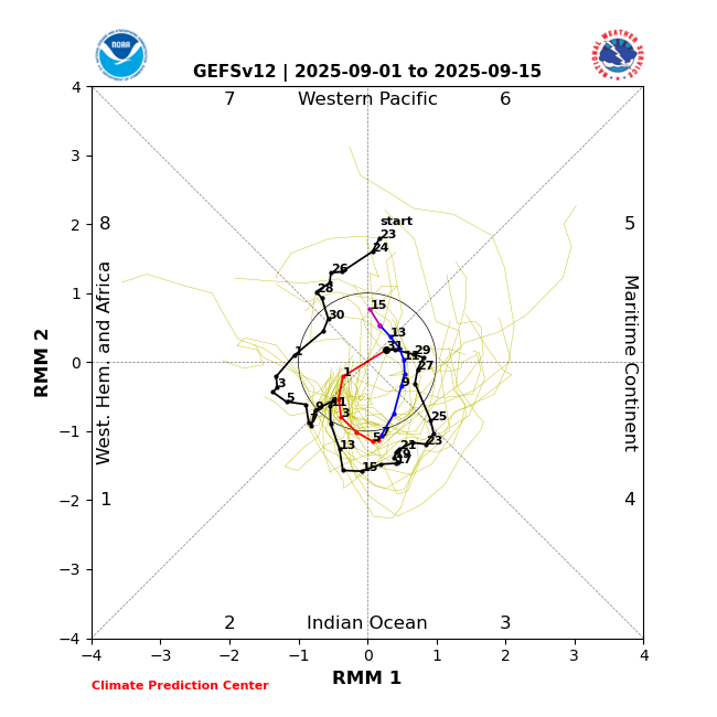
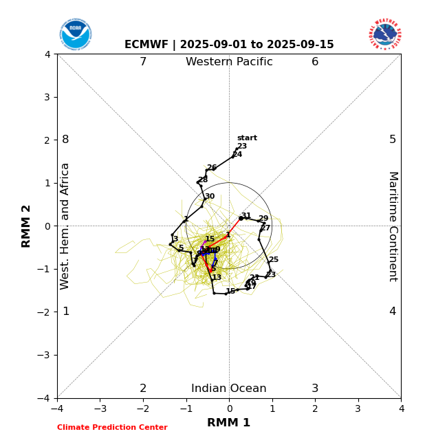
There’s an unusually large disagreement between GEFS and EPS regarding the MJO as they almost couldn’t be further apart! 1. GEFS heads for less threatening MC/W Pac (at low amp) pretty quickly and is on phase 6/7 border on 9/15 (supported by CMC): 2. Euro ens stuck mainly in phase 2, the most dangerous phase for Conus H hits in JAS (supported by JMA): I may be forgetting but I can’t recall ever seeing this degree of disagreement between these two! I don’t have a good feel for which will verify more closely but of course it could end up between the two.
- Today
-
-

September 2025 OBS-Discussion centered NYC subforum
JerseyWx replied to wdrag's topic in New York City Metro
You would think a dry summer like this would have been warmer. This month especially has been a rare August where the air condition window units were barely used. -
2025 Atlantic Hurricane Season
BarryStantonGBP replied to BarryStantonGBP's topic in Tropical Headquarters
humburrito coming soon -
Monthly stats: Highest temp: 89.1 Lowest Temp: 57.5 Rainfall: 9.18”
-
Thoughts on this