All Activity
- Past hour
-
I hope they soon narrow it down and you get some comfort/relief.
-
Here's some proof that the snow clouds came from the east. The Kewanechee Valley cam is from about 8000ft on Trail Ridge Road, on the west side of the Park. The snowbanks shown here melted down from about 9 ft high recently
-
Haven't experiences black flies ever until being in NH in late May and June. Those effers are nasty.
-
Records: Highs: EWR: 94 (2000) NYC: 93 (2000) LGA: 93 (2000) JFK: 87 (2000) Lows: EWR: 38 (1996) N YC: 37 (1891) LGA: 40 (1970) JFK: 38 (1970) Historical: 1840 - A powerful tornado wrecked many boats at the Natchez Landing in Mississippi, then plowed through the city on the bluff. The tornado killed 317 persons, and caused a million dollars damage. The force of the storm caused houses to burst open. The tornado was the most deadly and destructive in early American history. (David Ludlum) 1930: Record Maximum temperature for Washington, DC for the date is 95 °F. 1964 - The temperature at White Mountain 2, located in California, dipped to 15 degrees below zero to set a record for May for the continental U.S. (The Weather Channel) 1970: Record Minimum temperature for Washington, DC for the date is 38 °F. 1987 - Thirty-one cities in the western U.S. reported record high temperatures for the date. Highs of 93 degrees at Portland OR and San Jose CA were the warmest of record for so early in the season. The high of 92 degrees at Quillayute WA was a record for the month of May. The temperature at Sacramento CA hit 105 degrees. (The National Weather Summary) 1988 - A powerful storm in the north central U.S. produced up to three feet of snow in the Bighorn Mountains of Wyoming and the mountains of south central Montana. Up to five inches of rain drenched central Montana in less than 24 hours, and flash flooding in Wyoming caused a million dollars damage. (Storm Data) (The National Weather Summary) 1989 - Thirty-two cities in the central and eastern U.S. reported record low temperatures for the date, and 24 hour snowfall totals of 7.2 inches at Buffalo NY and 10.7 inches at Rochester NY were records for the month of May. While northerly winds ushered unseasonably cold air into the eastern U.S., temperatures warmed rapidly in the Great Plains Region, reaching the 90s in Kansas. The temperature at Manhattan KS soared from a low of 30 degrees to a high of 88 degrees. (The National Weather Summary) (Storm Data) 1990 - Gale force winds lashed the northern and central Pacific coast. A wind gust of 52 mph at Eureka CA established a record for the month of May. Strong winds over northeastern Colorado, associated with a fast moving Pacific cold front, gusted to 63 mph at Peetz. Snow developed over the northwest mountains of Wyoming late in the day, and Yellowstone National Park was whitened with 6 to 14 inches. (The National Weather Summary) (Storm Data) 1992: A freak snowstorm in the North Carolina Mountains dumped 40 inches at Mt. Pisgah and 18 inches at Mt. Mitchell..
-
That's deerfly behavior. Black flies scrape down to capillary level and lap up their dinner while the dainty mosquitos take their nourishment thru a straw. Leaves emerging all over. The various pastels of different trees aren't as spectacular as autumn, but the muted colors have their own charm.
-
58 / 49 bright sunshine. Partly cloudy mid 70s today and most of Thu, but clouds look to return by the later afternoon and evening. Trough swings south into the northeast and cuts off with rain and cool ENE flow 0.5 - 1.5 inches of rain, more North and west. Weekend looks to dry out and warm up to or low 80s on Mothers day. Trough cuts off under the ridge into the south then heads into the area next Tue/Wed with more clouds, showers and rain. Near normal overall through mid month, ridging looking to return towards the week of the 20th.
-
My wife has had this rodeo. That is one step closer to an answer, which ultimately is beneficial. Hope today you feel a bit better.
-
This morning was kind of surprising. A little damp out still but a nice cool morning with Sun was nice.
-
I have one eye on the May 17-18 time period. GFS has periodically been showing decent parameters and shear. But of course...it's WAY out there in fantasy range.
-
pretty good assessment here overall, yup. I mean I like to deeper dive into why these larger identified resonances behaved the way they did, but just as a step back recognition, agreed.
-
Yup...this too - wow, you're on a roll today. ha
-
-
Look like some rain chances every five or so days for a few weeks starting Thursday night in to Friday I guess? That would be welcome to get more opportunities in here over the next few weeks.
-
Can't complain about the rain as it was just enough to really wake up my backyards grass. Everything has shot up over the weekend. Enjoying a cool morning outside with bright blue skies.
-
alright alright. it's 62. making some progress.
- Today
-
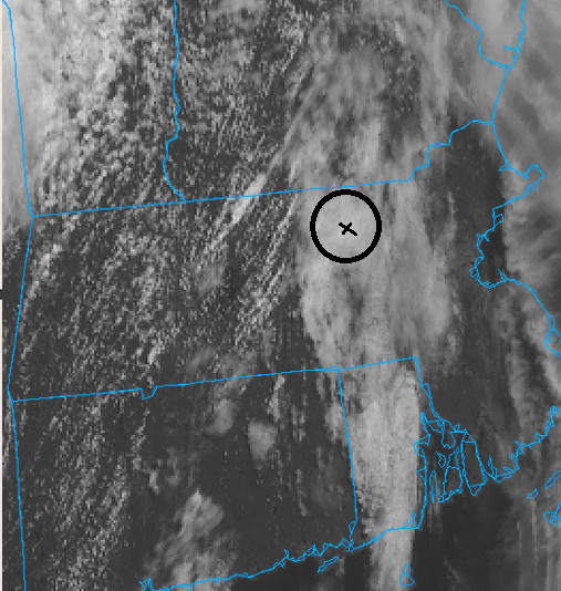
...more over, looping suggests this is a stationary attack on my dignity ... relative to the flow. It's like a negative exposure of Ray in a snow storm - this is pic is a metaphor for that.
-

Central PA Spring 2025
Itstrainingtime replied to canderson's topic in Upstate New York/Pennsylvania
Evening bloodwork panel did not come back good - my doctor is sending all of my information to Rheumatology now as he thinks it's likely an autoimmune disease. Maybe I'm finally heading towards at least knowing what I'm dealing with. -
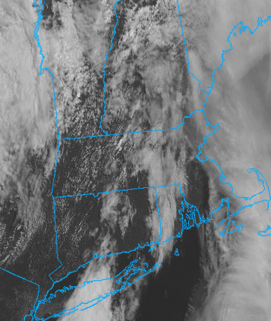
haha... i know. I saw pure blue out the windows. made coffee pure clouds. sat confirmed... it spontaneously blossomed as though making the observation itself somehow must have triggered it to do so. lol still completely overcast despite all this look of having more sun opportunities than cloud on this present sat vis image. it's one of those days whence the technology looks that way, but always overcast at ground truth. hate that - not that anyone asked.. but it's not the sun so much for me as it is the temperature. If it's warm... I'm sort of indifferent to whether it is cloudy. I'd take warm and wet over cold and wet, too. Although high dews and mold are concerns eventually...etc. But I don't grow to despise mid 50s in May if it caries on very long. The rain is over. Go away. Anyway, this image suggests the minority fractals are succeeding in keeping the majority unfairly cold - gee ...sounds like a present era sociological problem in America, doesn't it. haha
-
It sounds like Nibiru lol You should read the Isaac Asimov novel Nemesis. It's about an earth analog planet beyond Neptune that causes periodic mass extinctions on earth every 26 millions years because of its elongated orbit disturbing the Oort Comet cloud and causing a swarm of comets to head towards the inner solar system periodically. About the space and time thing, what we've seen seems (to me) to more proof of a *universe before the universe* in other words a cyclic universe with remnants left over from a previous cycle. We may also have found evidence of algae on an oceanic exoplanet that's about 124 light years away, our cosmic backyard.
-
Would be curious to know if that would be approaching any records for May. Can probably just download the daily/monthly data after and check.
-
Sun is out here. Could be a lowkey nice day?
-
heh... just mentioned it to Scott. yeah..
-
Oh, yeah... The bugs. I hate bugs!! They freak me out! I've already encountered so many while going out for walks. Including bees and wasps flying right near my face. The sheer peace of winter and not having them around. I miss it. Frogs are cool, though. I saw some around last summer.
-
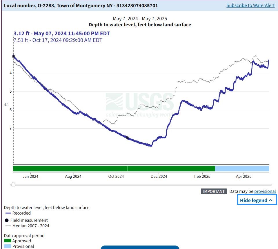
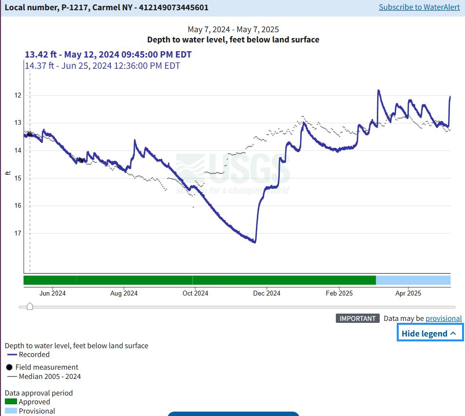
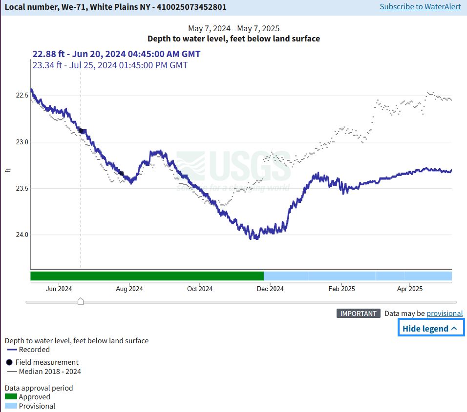
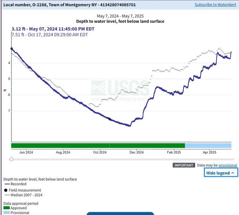
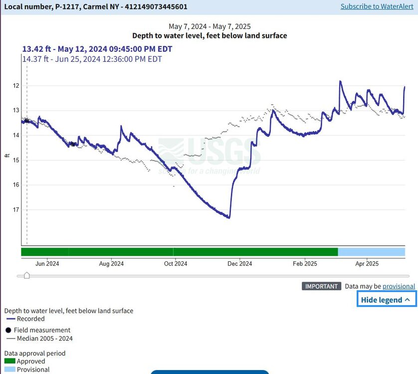
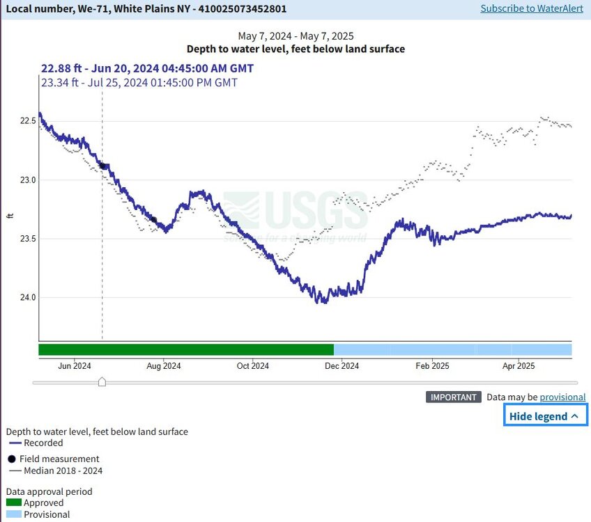
I just looked at a few monitoring wells in our neck of the woods to see how the ground water levels are doing. I looked at the levels over the past year, the blue are those readings and the lighter gray line is the median level. You'll see Montgomery is normal, Carmel is slightly above normal and White Plains is slightly below.
-
I've been battling that thing... The telecon spread does not really suggest the depth and amplitude the operational guidance keep insisting of that thing. I'm waiting for them to finally respond to the 'non-linearity' of the surrounding, lowering favorability for having that depression in the TV in the first place, but they keep diggin that sumnabitch in there like an Alabama tick. Namely, there's a robust -PNA. In fact, ...one that has gotten more robust over the last 3 days days. Meanwhile, there doesn't appear to be any other indexes that suggest there's contention of proxy over the circulation mode... In other words, it all seems more -PNA ... So that TV whirl should be weaker. Nope... okay